Seasonality
Summary
Gneiss
Primarily moderate (5.5 to 5.10) sport routes on generally slabby gneiss/diorite looking down on a picturesque lake.
Description
All day sun
Wet in rain
South
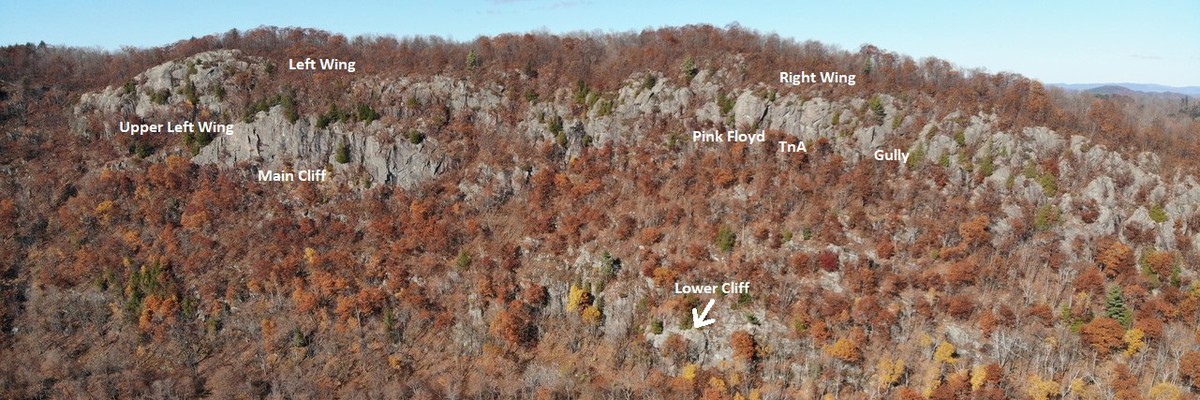
Lac Sam is a small lake about 70km north of Ottawa. It is horse-shoe shaped, with steep hills and cliffs rising out of the back of the horseshoe up to almost 250m in total height gain, though not all of it rock face.
Being south-facing, Lac Sam is best as a spring and fall crag. On a sunny mid-summer day, it will be hot, and even the shadier bases (e.g. Lower Cliff) will be warm.
While Right Wing and Main cliff required some experience, being rappel-in, climb-out crags, both Upper Left Wing and Lower Cliff are reached by a trail to the base, and are "normal" climb-from-the-ground crags with relatively flat bases.
Development has slowed as of 2023, with most of the obvious lines on the currently open walls having been developed. But, there is still undeveloped rock, so there are still opportunities to open new routes, or perhaps even a new wall.
Even the developed areas are "young" so be wary of loose rock, or holds that may break. A helmet is a very good idea. Further, this is set in a hill-side, and after any heavy rain, and especially in the spring, hill-side will wash onto the climbs -- small rocks or loose gravel being the most common issue. If you encounter a small rock on a hold or ledge of a climb, stick it in your pocket until you get to the base, and empty your pockets, there.
Can't decide where to start? Here's what you get at each cliff:
- "Right Wing" - quickest approach (15 min), but you'll have to rappel in unless you go to gully wall, longest single-pitch routes (up to 37m), generally some of the cleanest rock as it's been climbed the most, however the base is the steepest, shady at the bottom of TnA Wall, more sun-exposed on Pink Floyd Wall.
- "Left Wing" - takes another 10 minutes to get to from "Right Wing"
- "Upper Left Wing" - approach is to the base, with a reasonably flat base, mostly shorter single-pitch climbs, with several 5.10+ choices
- "Main Cliff" - below and right from "Upper Left Wing", rappel-in, has some of the longest climbs (45m, 2 pitches) at the crag
- "Lower Cliff" - approach is about 20 to 25 minutes including a (roped) scramble down a steep gully. The base which is generally comfortable, most shaded.
Developer discussion: https://www.thecrag.com/discussion/3952671888
Access issues
Other than The Swamp, the cliffs are on crown land.
Note: the private land sign (which appeared in 2018) on the left side of the road as you approach the parking is a lie -- that is crown land. The private land, no hunting sign on the right side of the road was not put up by the land-owner of that particular chunk of land, but by someone else -- the land-owner is unsure who, though he has a guess. (Conversation with land-owner, fall 2018.)
Approach
Most of the climbing is on the "Upper Faces", so this should be your normal approach unless you know what you're doing.
Upper Faces approach:
Normal parking location: http://maps.google.ca/maps?q=45.913049,-75.800455&hl=en&ll=45.912914,-75.800568&spn=0.005173,0.011362&sll=45.902911,-75.805463&sspn=0.01553,0.032015&num=1&t=h&vpsrc=6&z=17 should link to a map that indicates where the pull-off and start of the trail is.
From Ottawa, find yourself on 307 North out of Cantley. Take a left on chemin Des Voyageurs (towards Denholm), straight through the 4-way stop, then left when the road ends at a T-Junction at chemins du Poisson Blanc. Follow this until you hit a left turn for Lac Sam. Shortly (about 350m) after turning off Chemin du Poisson Blanc, there is a wider area with a gravel road branching off to the right. This road (Chemin du Lac Sainte Marie, though unmarked as such) leads over to Lac Sainte Marie after a few twistings and windings. After about 4.8 km, there will be a one-lane track turning off to the left, turn on this. Less than 200m up there will be a pull-off to the right with space for about 5 cars (if you park carefully) and a small trail leading into the brush on the opposite side of the track (currently marked with orange tape). Park here and hike up the trail.
Hiking up the trail will take 10-15 minutes, and bring you out at the top of the escarpment, onto the ridge-top trail. This approach intersects the ridge-top trail above the "TnA Wall" sector of "Right Wing". Descend towards the lake for Right Wing, or turn right and hike (initially more up) along the ridge-top trail for "Left Wing" (see sector for details).
For "Lower Cliff", split left off the main approach trail before crossing the stream (see the crag for details), but it is still a bit "adventurous".
Alternate for "Lower Cliff" (lake approach) and for "Jumping Rock" (DWS) approach:
There is a public access beach with some parking at the tip of the south/west arm of the lake. Boats can be launched from this point. The trip is about 1.5-2km up the lake to the main faces. Then lowest of the cliffs are about a 10-minute bushwhack directly upwards. Lower Cliff is almost directly above the eastern tip of the small island in the north corner of the lake.
Jumping Rock is another 1.5km down the other arm of the lake, past another small island.
5.Superfunwall can be approached by boat, travelling all the way around the lake, or by a bushwhack/trail.
(Google maps can be used to find "Lac Sam, Quebec". )
Ethic
New routes welcome. Please document them on the crag.
Developer discussion: https://www.thecrag.com/discussion/3952671888
Bolting fine; rap-bolting fine. Please bolt for safe sport or mixed routes. If a route is almost completely bolted, bolt it as sport, rather than leaving just a couple of gear placements needed on an otherwise sport route.
There is lots of rock, try to avoid squeeze jobs.
If something has been climbed on gear, please don't retro-bolt without FA's consent.
History
As kids, in the 70s, we used to canoe accross the lake and hike/scramble up "the mountain". To my knowledge, none of the main cliffs have had any technical climbing done on them before 2010 (possibly one free solo by Randy Reed) and the start of development by David Gibbs and friends in 2011.
A bit of climbing and cleaning was done on 5.SuperFunWall in summer of 2009 by David Gibbs, Randy Reed, and a friend of Randy's.
The Jumping rock has been climbed DWS a few times over the years.
Tags
Plan your Trip
Did you know?
Did you know that you can create an account to record, track and share your climbing ascents? Thousands of climbers are already doing this.


Accommodations nearby more Hide
Share this
Nearby Icons
| 5.5 | ★ Sunday Morning Stroll | ||
| 5.8 | ★★★ Lemon Technique | ||
| 5.9 | ★★ Kate and David's Excellent Adventure | ||
| 5.10d | ★★★ Arriving Somewhere (but not here) |
Photos Browse all photos

Pink Floyd Wall - Pink FLoyd Wall - Right

Simon McMillan at Lower Cliff - Simon on Left Out

Upper Left Wing - upper left wing.jpg

Jumping Rock - Smaller Jump.
Thu 20 Apr
Check out what is happening in Lac Sam.
Get a detailed insight with a timeline showing
- Ticks by climbers like you
- Discussions of the community
- Updates to the index by our users
- and many more things.
Login to see the timeline!