 Escalada en varios largos en el largo acantilado desde Famara hasta el extremo norte de Lanzarote.
 Multipitch climbing on the long Cliff from Famara to the north end of Lanzarote.
En todas las zonas de escalada hay tornillos de diferentes edades y condiciones. Verifique antes de subir y juzgue usted mismo la estabilidad del cerrojo. Los tornillos viejos u oxidados podrían romperse. ¡Sube bajo tu propia responsabilidad!
In all climbing areas are bolts of different age and condition. Check before your climb and judge bolt stability yourself. Old or rusted bolts could break. Climb at your own responsibility!
See warning details and discuss
Escalada en varios largos en el largo acantilado desde Famara hasta el extremo norte de Lanzarote.
Multipitch climbing on the long Cliff from Famara to the north end of Lanzarote.
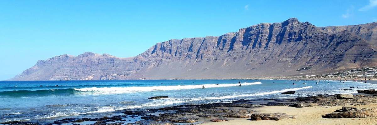
La parte más antigua de Lanzarote se encuentra en el norte de la isla. Lleva el nombre del pueblo y la playa de Famara, ubicada en Bahía de Penedo, la bahía, que se distingue claramente al oeste de la península. La característica más importante es el Risco de Famara, un enorme acantilado de unos 15 km de longitud y una altura de hasta 672 m. El punto más alto de Lanzarote, Peñas del Chache, es también el punto más alto de este acantilado. Si bien es fácilmente accesible desde su lado este, el Risco de Famara cae con una caída promedio de 500 m verticalmente hacia el mar hacia el oeste. La roca es de basalto sólido solo en su parte superior, mientras que la parte inferior del acantilado es quebradiza y podrida. Para los excursionistas hay dos alternativas interesantes: una caminata expuesta a lo largo de la cresta de ruptura y un camino de mulas abandonado que atraviesa el acantilado a media altura. El camino fue abandonado por desprendimiento de rocas y hoy en día tiene algunos tramos desafiantes.
The oldest part of Lanzarote can be found in the north of the island. It is named after the village and beach of Famara, located at Bahia de Penedo, the bay, which is plainly distinguishable to the west of the peninsula. The most important feature is Risco de Famara, a massive cliff of some 15km length and a height of up to 672m. Lanzarote's highpoint, Peñas del Chache, is also the highest point of this cliff. While easily reachable from its eastern side Risco de Famara drops with an average drop of 500m vertically into the sea to its west. The rock is solid basalt in its topmost part only while the lower part of the cliff is brittle and rotten. For hikers there are two interesting alternatives: an exposed hike along the break-off ridge and an abandoned mule road cutting through the cliff at half height. The road was abandoned due to rockfall and nowadays has some dangerous challenging sections.
"Pared de Famara" and "Via falsa de Famara" mentioned here. And "Risco de Famara" mentioned here.
A partes de la comunidad de escalada local les gusta que sus trabajos sean publicados y disfrutados por otros escaladores. Otras partes están preocupadas por el impacto de más escaladores extranjeros. Todo Lanzarote es una reserva de la biosfera protegida por la UNESCO, así que compórtese de manera responsable (como todo escalador debería hacer de todos modos). No dejes basura y lleva la basura de los demás contigo. Si tiene que ir al baño, esconda / entierre sus restos sin impacto visual ni de olor. Compórtese tranquilo en el risco, si hay otras personas alrededor, sujete a su perro con la correa. No bloquee la carretera local y estacione de manera responsable. ¡Gracias!
Parts of the local climbing community like to have their work published and enjoyed by other climbers. Other parts are worried about the impact of more and foreign climbers. All of Lanzarote is a protected UNESCO biosphere reserve, so please behave responsible (like every climber should do anyway)! Don't leave trash and take the trash of others with you. If you have to go to toilet, hide/burry your remnants withouth visual and odour impact. Behave quiet at the crag, if other people are around leash your dog. Don't block local roads and park responsibly. Thank you!
This crag does not have approach information. Could you describe the approach to this crag?
If you can help provide a better quality resource for the climbing community then please click 'edit this crag' button near the top of the page.
Get a detailed insight with a timeline showing
Login to see the timeline!


