Use this Region Guide to easily find and compare Crags.
Table of contents
- 1.
Islas Canarias / Canary Islands
7372 in Region
-
1.1.
Tenerife / Teneriffa 3791 in Crag
- 1.1.1. South / Southeast 2234 in Area
- 1.1.2. Southwest 490 in Area
- 1.1.3. North 378 in Area
- 1.1.4. Anaga / Northeast 333 in Area
- 1.1.5. Parque Nacional del Teide / Centre 356 in Area
-
1.2.
Gran Canaria 1329 in Crag
- 1.2.1. La Aldea 45 in Area
- 1.2.2. Tamadaba 316 in Crag
- 1.2.3. Guayedra (Agate) 0 in Crag
- 1.2.4. Cenobio 46 in Crag
- 1.2.5. Moya 75 in Crag
- 1.2.6. Quintanilla 20 in Crag
- 1.2.7. Bañaderos / Principal 19 in Crag
- 1.2.8. Cueva de Arucas 6 in Crag
- 1.2.9. Costa de Arucas / El Guincho 35 in Area
- 1.2.10. Costa Ayala 17 in Cliff
- 1.2.11. Riquianez / La Guitarrilla 28 in Crag
- 1.2.12. El Confital 7 in Crag
- 1.2.13. Tunel de TaraClimb 20 in Artificial
- 1.2.14. Telde 9 in Area
- 1.2.15. El Sardo / The Sardinian 10 in Crag
- 1.2.16. Guiniguada 21 in Area
- 1.2.17. Las Meleguinas / Santa Brígida 47 in Area
- 1.2.18. Rocódromo del Parque Juan Pablo II 13 in Gym
- 1.2.19. Roque Narices 7 in Cliff
- 1.2.20. Roque Nublo y Roque La Rana 27 in Crag
- 1.2.21. Montana del Asserador 27 in Area
- 1.2.22. Ayacata 23 in Crag
- 1.2.23. La Goleta 11 in Crag
- 1.2.24. Los Hornos 42 in Area
- 1.2.25. La Gañifa / Morrón de La Agujerad 1 in Cliff
- 1.2.26. Diamante 0 in Sector
- 1.2.27. Candelilla 43 in Crag
- 1.2.28. Salto del Perro 10 in Cliff
- 1.2.29. Mogan 107 in Field
- 1.2.30. Chira 0 in Area
- 1.2.31. Lomo Pedro Afonso 3 in Crag
- 1.2.32. Ayagaures 50 in Crag
- 1.2.33. Fataga 106 in Crag
- 1.2.34. Sorrueda 122 in Crag
- 1.2.35. Fataga Piconera 25 in Crag
- 1.2.36. Berriel 1 in Crag
- 1.2.37. Rocodromo 0 in Gym
- 1.2.38. unidentified boulders 1 in Boulder
-
1.3.
Lanzarote 721 in Crag
- 1.3.1. Bolos de Orzola 40 in Crag
- 1.3.2. Jameos de Arriba / Upper Jameos 22 in Area
- 1.3.3. Cueva de Orzola / Cueva de los Escaladores 25 in Crag
- 1.3.4. Monte Corona Lava Tube 81 in Crag
- 1.3.5. Guatiza / Teneguime 63 in Crag
- 1.3.6. Cueva del Agua 6 in Cliff
- 1.3.7. Presa de Mala 5 in Crag
- 1.3.8. Teseguite / Stratified City West 14 in Field
- 1.3.9. Black and White / Stratified City 9 in Field
- 1.3.10. El Regalito / Zona de Bulder / Regalito del Reyes 186 in Field
- 1.3.11. El Detallito / Barranco de la Espoleta 30 in Field
- 1.3.12. Barranco Mulión 15 in Field
- 1.3.13. Hang On Lanzarote Climbing Centre 18 in Gym
- 1.3.14. La Pedrera 18 in Crag
- 1.3.15. Puerto Calero 18 in Crag
- 1.3.16. Playa Quemada 2 in Field
- 1.3.17. Playa Blanca 20 in Area
- 1.3.18. Atlante del Sol 11 in Crag
- 1.3.19. Las Maretas Seacliffs 62 in Crag
- 1.3.20. Collado de Cho Castro / South of the Salt Pans 10 in Field
- 1.3.21. Las Bombas 19 in Field
- 1.3.22. Tinajo Area 40 in Area
- 1.3.23. Pared de Famara 2 in Crag
- 1.3.24. Risco de Famara 2 in Crag
- 1.3.25. Balcón Gracioso / Mirador del Rio 3 in Crag
-
1.4.
Fuerteventura / Strong Fortune 638 in Crag
- 1.4.1. Las Peñitas / Barranco de las Peñitas 449 in Crag
- 1.4.2. Garganta del Diablo / Devil's Throat / Barranco de la Herradura 30 in Crag
- 1.4.3. Túnel Puerto 1 in Artificial
- 1.4.4. Sicasumbre 5 in Cliff
- 1.4.5. Pecenescal / Playa de Barlovento 46 in Field
- 1.4.6. Lengua Basaltica / Barranco de las Campanas / Basalt Tongue 41 in Field
- 1.4.7. Punta Guadalupe / Playa de La Pared 18 in Crag
- 1.4.8. Faro de La Entellada / Lighthouse of La Entellada 5 in Crag
- 1.4.9. Peñón del Roque / Rock Tower 2 in Cliff
- 1.4.10. Roque del Moro 9 in Cliff
- 1.4.11. Peña Horadada / Rock Arch 1 in Cliff
- 1.4.12. Playa de Garcey 4 in Crag
- 1.4.13. Gran Tarajal 10 in Boulder
- 1.4.14. Morro Jable 6 in Cliff
- 1.4.15. Las Gaviotas 4 in Field
- 1.4.16. Montana Cardon y El Castillo 1 in Crag
- 1.4.17. Pico de la Muda 2 in Crag
- 1.4.18. Pico de la Zarza 2 in Cliff
- 1.4.19. Caleta de la Ballena 1 in Cliff
- 1.4.20. Psicobloc/Deepwatersoloing 0 in Crag
- 1.4.21. Caleta de la Madera 0 in Crag
- 1.4.22. Barranco de la Antigua 0 in Crag
- 1.4.23. Barranco de Pájara 0 in Cliff
- 1.4.24. Barranco de Esquinzo 0 in Crag
- 1.4.25. Skatepark La Tunera Climbing Wall 1 in Artificial
- 1.4.26. Climbing Wall Acua Water Park 0 in Gym
-
1.5.
La Palma 650 in Crag
- 1.5.1. Barranco de la Herradura / Fardos de Pajullo 9 in Crag
- 1.5.2. Charco Azules 2 in Crag
- 1.5.3. Barranco del Agua / Puntallana 96 in Crag
- 1.5.4. Barranco de la Madera 65 in Crag
- 1.5.5. Barranco de Las Nieves 10 in Field
- 1.5.6. Barranco de los Pajaros 26 in Crag
- 1.5.7. El Nambroque 11 in Crag
- 1.5.8. Los Roques del Teneguia 8 in Crag
- 1.5.9. Volcan Martin 1 in Cliff
- 1.5.10. Mendo 21 in Crag
- 1.5.11. Campanarios de Jedey / Bell Towers / Needles of Jedey / Volcano Martin / Agujas de Volcan de Tajuya 65 in Crag
- 1.5.12. Hoyo de la Sima 1 in Cliff
- 1.5.13. El Remo Beach 3 in Field
- 1.5.14. Beach Warden Puerto Naos 1 in Boulder
- 1.5.15. El Riachuelo / El Paso 15 in Crag
- 1.5.16. Peña del Diablo 58 in Crag
- 1.5.17. Las Angustias 50 in Crag
- 1.5.18. Caldera de Taburiente 26 in Crag
- 1.5.19. Barranco de El Roque 1 in Crag
- 1.5.20. Barranco de Izcagua 86 in Crag
- 1.5.21. Barranco Briestas 88 in Crag
- 1.5.22. Barranco de Fernando Oporto 4 in Crag
- 1.5.23. Santo Domingo 1 in Crag
- 1.5.24. Juan Adalid 1 in Crag
- 1.5.25. Xtreme Park Los Llanos 1 in Gym
- 1.5.26. Climbing Gym 0 in Artificial
-
1.6.
La Gomera 191 in Crag
- 1.6.1. San Sebastian 0 in Area
- 1.6.2. Chejelipes - La Laja 12 in Area
- 1.6.3. Barranco de Juan Vera / Barranco del Cabrito 13 in Crag
- 1.6.4. Roques de Garajonay / Los Roques 11 in Area
- 1.6.5. Pinar de Salamanca / Tejiade / Risco Blanco 51 in Crag
- 1.6.6. Tapahuga 11 in Crag
- 1.6.7. Alajero 0 in Crag
- 1.6.8. Targa 0 in Crag
- 1.6.9. Roque de Imada 10 in Crag
- 1.6.10. Arguayoda / El Negrin 33 in Area
- 1.6.11. Fortaleza de Chipude 1 in Crag
- 1.6.12. Valle Gran Rey 22 in Area
- 1.6.13. Sea Wolf 1 in Cliff
- 1.6.14. Roques de los Organos 4 in Crag
- 1.6.15. Roques de Arguamul 0 in Cliff
- 1.6.16. Castillo del Mar 1 in Cliff
- 1.6.17. Roque Cano 13 in Crag
- 1.6.18. Dwarfs Throne / Zwergenthron 1 in Cliff
- 1.6.19. Roques de San Pedro / Los Gemelos / The Twins / Roques Pedro y Petra 6 in Crag
- 1.6.20. Aguja de Playa de la Caleta 1 in Cliff
-
1.7.
El Hierro / The Iron 52 in Crag
- 1.7.1. Las Playas 19 in Crag
- 1.7.2. El Tejal 10 in Cliff
- 1.7.3. Tamaduste 4 in Cliff
- 1.7.4. Arenas Blancas 14 in Field
- 1.7.5. Charco Manso 3 in Area
- 1.7.6. Arco de la Tosca 1 in Crag
- 1.7.7. Lava Tunnel 1 in Cliff
- 1.7.8. rock potential 0 in Crag
-
1.1.
Tenerife / Teneriffa 3791 in Crag
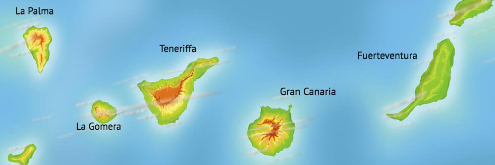
1. Islas Canarias 7,372 routes in Region
- Summary:
-
Escalada deportiva, Búlder y otros estilos
Lat / Long: 28.515809, -15.763786
1.1. Tenerife 3,791 routes in Crag
- Summary:
-
Escalada deportiva, Búlder y otros estilos
Lat / Long: 28.321967, -16.546673
Resumen
Tenerife excells in providing all year round climbing, from sunny suntraps to secluded and shaded areas.
descripción
There is a variety of styles and rock formations, that might require a visitor to spend several days to explore them all. Water polished basalt is fairly common and can be tricky for the inexperienced.
restricciones
Most places in Tenerife enjoy free access, however, some require permission which can often be obtained in-situ through QR code scanning, such as Guaria near Guia de Isora, and also some places in the Teide National Park.
Acceso
Unfortunately, most places in Tenerife are not accessible by public transport directly, having to walk long hours to the spots, save for a few crags, such as Vistamar, Poris, Guasiegre, and others. With a car, however, everything is very close by, especially in the Arico area. Most crags will be only a few minutes walk from the car park, the most being around 17 mins.
Alojamiento
You are in Tenerife, there are hotels and apartments everywhere! However, if you are looking for climbing specific accommodation, there are two in the Arico area, Tenerife Climbing House with rooms and tents and the local climbing store Roxtar and the more community like hostel Basecamp Ortiz, both are relatively close walking distance to the Arico crags. A climber basecamp hostel for the north crags is 'El Sueño de Mamá' in Tegueste.
Ética
Please keep the crags noise free and clean. Take your trash and toilet papers with you. Locals tend to bring dogs to the crag. It is good manners to use your own gear at the anchors for lowering or setting up top-ropes. Use the anchor rings/carabiners only for the final lower-off after cleaning.
1.1.1. South 2,234 routes in Area
- Summary:
-
Escalada deportiva, Búlder y otros estilos
Lat / Long: 28.244122, -16.429964
restricciones
No issues
Alojamiento
http://tenerifeclimbinghouse.com - website also offers some beta
1.1.2. Southwest 490 routes in Area
- Summary:
-
Escalada deportiva, Escalada clásica y otros estilos
Lat / Long: 28.147853, -16.734469
1.1.3. North 378 routes in Area
- Summary:
-
Escalada deportiva, Búlder y otros estilos
Lat / Long: 28.425622, -16.625802
1.1.4. Anaga 333 routes in Area
- Summary:
-
Escalada deportiva, Escalada clásica y otros estilos
Lat / Long: 28.497830, -16.245792
Resumen
Huge faces crop up from the steep green hills of Taganana, the most beautiful part of Tenerife.
descripción
Many huge lines exist up here, but many of them are not well publicized. Climbing has existed since the 70s and a strong local community follows these routes. Ask the locals for more information.
1.1.5. Parque Nacional del Teide 356 routes in Area
Equipo fijo: No equipamiento de nuevas rutas / No bolting !
 No equipamento nuevas vías de escalada en el Parque Nacional del Teide. La situación de la escalada en el Parque Nacional del Teide es delicada y si la gente la ignora puede provocar que se prohíba definitivamente la escalada. Gracias.
 No bolting of new climbing routes in El Teide National Park. The climbing situation at El Teide National Park is delicate and if people ignore this it may cause climbing to be permanently prohibited. Thank you.
Ver Detalles de la advertencia y Discusiones
- Summary:
-
Escalada deportiva, Escalada clásica y otros estilos
Lat / Long: 28.279201, -16.582485
descripción
New book with topos:  "Entre Roques y Alisios – Vivencias de un escalador.", 2022, Javier Martín-Carbajal, ISBN 9788416785902, link.
Old guidebook: "Principales Zonas de Escalada en Roca - Parque Nacional del Teide - Isla de Tenerife", 2004, Fernando Cova del Pino, Javier Martin-Carbajal, Antonio Ramos Villar, ISBN 9788460903000, link.
1.2. Gran Canaria 1,329 routes in Crag
- Summary:
-
Mayormente Escalada deportiva
Lat / Long: 27.954669, -15.590840
Resumen
Mostly sport-climbing, some trad, and bouldering in a pleasant climate.
descripción
Some old topos for sport-climbing
Attractive all-year destination, as never being really cold or hot. Mainly smaller crags on volcanic rock with lots of potentials.
Sadly the climbing sector seems to have been heavily commercialized, and public information removed. Topo is now for sale here.
GUIDEBOOKS
"Guia de escalada deportiva en Gran Canaria" by Climbo, 2015, ISBN 9788460659822, out of sale.
"GRAN CANARIA. GUÍA DE ESCALADA DEPORTIVA" by Christian Fernández del Valle, 2011, ISBN 9788461501649, out of sale.
1.2.1. La Aldea 45 routes in Area
- Summary:
-
Todo Escalada deportiva
Lat / Long: 27.989012, -15.727975
Resumen
Barranco de La Aldea climbing area.
descripción
Recently bolted area in the northwest of the island with tons of potential. Perfect crag to climb all year long.
restricciones
The parking is pretty small, so let's try to meet in La Aldea town in order to share cars and try to use less amount parking space as possible.
Acceso
From the parking spot ( 27.988032, -15.741339) it takes like 15 minutes to get from the wall while hiking up. The wall is already visible from the car.
1.2.2. Tamadaba 316 routes in Crag
- Summary:
-
Todo Escalada deportiva
Lat / Long: 28.059021, -15.693980
Resumen
The biggest and most gorgeous crag on the island.
descripción
Possibly the best crag on the island in terms of the number of routes, quality of rock, and the beauty of the place itself.
It is possible to climb almost all year long, except those cold winter or foggy days.
Acceso
(28.057261, -15.689133)
This is the only legal parking place, so please park there if you want to avoid a nice fine. Forest guards are constantly checking it out.
From the parking lot, it is relatively easy to get lost depending on the sector you wanna reach out to. The official guidebook has shared geolocation QR's of the sectors, so just use them once arrived at the parking lot.
1.2.3. Guayedra (Agate) 0 routes in Crag
1.2.4. Cenobio 46 routes in Crag
- Summary:
-
Todo Escalada deportiva
Lat / Long: 28.137429, -15.601537
Resumen
The most popular crag in the north of the island containing also has quite a few boulders around.
descripción
One of the best crags on the island. Perfect for those sunny super hot summer days as it is always fresh there. Super good rock quality and with the honor to have received some of the best rock climbers ever like Chris Sharma, Dani Andrada, Steve McClure, and many others.
Acceso
From the parking lot, it takes around 20min walking up all the way through the valley until the end of the same. Some details about the hike here.
1.2.5. Moya 75 routes in Crag
- Summary:
-
Todo Escalada deportiva
Lat / Long: 28.132015, -15.590630
Resumen
Popular crag in the north of the island where is possible to climb all year round.
descripción
Ideal crag for those climbers in the sixth grade, mostly short routes where slopers and bouldery start are the predominant types of climbing. Very compact rock in general.
There are walls facing the east and west, so it is always possible to find some shadow.
Acceso
From the parking lot walk downwards the road until the entrance of the valley (28.137649, -15.591846) always following the water channel. After 5 minutes of walking the walls will be visible.
1.2.6. Quintanilla 20 routes in Crag
- Summary:
-
Todo Escalada deportiva
Lat / Long: 28.144434, -15.551081
Resumen
Popular small sector in the north of the island with less than a minute of approach and easy to reach by car or bus.
descripción
Recently this crag has seen some rebolting and new routes are done by Carlos Arocha, a local legend in climbing. On his personal blog he has shared the topos of this crag, among with some others on the island and a lot of useful information about climbing techniques. The Crag community thanks you for all that work.
Acceso
The walls are in front of the parking lot
1.2.7. Bañaderos 19 routes in Crag
- Summary:
-
Todo Escalada deportiva
Lat / Long: 28.142793, -15.526038
Resumen
Small crag with mostly short routes close to the city and less than a minute of hiking.
https://www.canariasclimb.com/escapada-de-escalada-a-gran-canarias-10-5-19/
descripción
This crag has seen recently some rebolting and new routes thanks to a local legend and pioneer of climbing in the island Carlos Arocha. On his personal blog he has shared some more info about the sector and a lot of helpful information about proper climbing techniques all along with quite a lot of topos from other places on the island. We truly thank him for that.
The only and main sector
Acceso
The walls are just a few seconds walking from the parking lot.
1.2.8. Cueva de Arucas 6 routes in Crag
- Summary:
-
Mayormente Escalada deportiva
Lat / Long: 28.142941, -15.510767
Resumen
A small cave that can be fun for some bouldering. There are some routes as well but the bolts might not have an optimal state. Not really recommended.
Acceso
(28.141886, -15.511330) Follow down the streambed.
1.2.9. Costa de Arucas / El Guincho 35 routes in Area
- Summary:
-
Todo Escalada deportiva
Lat / Long: 28.145292, -15.511001
Resumen
descripción
Recently bolted crag located 10 minutes from the capital city and with less than a minute of walking. Mostly short and powerful routes on good holds.
restricciones
The terrain seems to be private, so let's keep it clean and try to don't place our gear on the common path for the villages located there.
Birds nesting have been seen between routes number 4 and 10, so let's avoid climbing those routes during the nesting season as they did arrive there way longer than climbers did.
Acceso
From the parking lot, it takes just about a minute. The crag is located at the bottom of the valley.
1.2.10. Costa Ayala 17 routes in Cliff
- Summary:
-
Todo Escalada deportiva
Lat / Long: 28.141662, -15.493883
descripción
Some old topo including info about the rappels for accessing and belaying
One of the oldest crags on the island. Rebolted with chemicals and really good rock quality but not really popular due that some routes requiring belaying from the wall and the access is via rappel.
Acceso
(Entrance-34.077876, 150.855652)
(28.141481, -15.496713)
From the parking lot, it takes about 5 minutes to follow the right path which goes above the ocean cliff where the rappels are located. A rope of a minimum of 70 meters is required.
1.2.11. Riquianez 28 routes in Crag
- Summary:
-
Todo Escalada deportiva
Lat / Long: 28.104980, -15.515961
Resumen
Topo.
Esta escuela es muy adecuada para principiantes y escaladores de sexto grado.
This crag is very suitable for beginners and climbers in the 6th grade.
descripción
Uno de los sectores más nuevos de la isla y también conocido "La Guitarrilla". Perfecto para principiantes y escaladores en desarrollo del sexto grado. Roca muy compacta por lo general.
Es posible escalar todo el año, siendo posible encontrar siempre algún sector a la sombra.
One of the newest crags on the island and is also known as "La Guitarrilla". Perfect for people who are starting to climb and those who are climbing into the sixth grade.
It is possible to climb all year long as there are always some shady sectors.
Acceso
Siga la ruta de senderismo hacia el oeste durante 300 m.
Follow the hiking path west for 300m.
1.2.12. El Confital 7 routes in Crag
- Summary:
-
Mayormente Escalada deportiva
Lat / Long: 28.174948, -15.425343
descripción
1.2.13. Tunel de TaraClimb 20 routes in Artificial
- Summary:
-
Todo Escalada deportiva
Lat / Long: 28.002146, -15.420330
1.2.14. Telde 9 routes in Area
- Summary:
-
Todo Escalada deportiva
Lat / Long: 27.992163, -15.429728
Resumen
Small crag with some interesting routes.
descripción
Mostly short and bouldery routes on basalt rock with sloper holds.
The routes are pretty new and possibly dirty after the last rains. Beware of using a helmet for climbing and belaying.
Acceso
From the parking lot (27.991861, -15.436120) is just about following the path behind the chapel and going down to the Barranco and after 5 minutes of walking its way down the first route would be on the right side.
1.2.15. El Sardo 10 routes in Crag
- Summary:
-
Todo Escalada deportiva
Lat / Long: 28.066059, -15.473186
descripción
En las afueras de Las Palmas, al lado del barrio de Tamaraceite. La roca es una brecha volcánica de color rojizo y buena adherencia. Tiene dos sectores, uno con orientación Norte y otro con orientación Sur, lo que permite escalar en cualquier época del año.
On the outskirts of Las Palmas, next to the Tamaraceite neighbourhood. The rock is a volcanic breccia with a reddish color and good adherence. It has two sectors, one facing North and the other facing South, which allows climbing at any time of the year.
Topo.
Acceso
1.2.16. Guiniguada 21 routes in Area
- Summary:
-
Todo Escalada deportiva
Lat / Long: 28.073066, -15.458962
Resumen
One of the very first crags in the north of the island to be bolted.
descripción
This crag seemed to be very popular a few years back, which is a pity because there is some potential and it has seen some new routes recently bolted. Currently, most of the routes are in a bad state. Don't really worth checking it out.
restricciones
The road is quite narrow, do not park affecting the pass to the other cars or in front of the houses.
Acceso
From the parking lot, the hike is about going down to the valley and hiking up until the end of the same. After a few minutes, La Piedra sector will appear on the right side and some 15 minutes later is El Caidero sector.
1.2.17. Las Meleguinas 47 routes in Area
- Summary:
-
Todo Escalada deportiva
Lat / Long: 28.047905, -15.497045
Resumen
Esta escuela es muy adecuada para principiantes y escaladores de sexto grado.
This crag is very suitable for beginners and climbers in the 6th grade.
descripción
Uno de los sectores más nuevos de la isla. Mucha variedad de rutas en cuanto a altura y estilo y con la mayoría de las rutas entre sexto grado y muy bien aseguradas.
Es posible escalar todo el año, preferiblemente en la sombra después de la tarde. Incluso en invierno ya que, mientras haya un poco de sol, no es muy cómodo escalar con él.
One of the newest crags on the island. Quite a lot of variety of routes in terms of high and style and with most of the routes between in the sixth grade and very safe bolted.
It is possible to climb all year long, preferably on the shadow after evening. Even in winter since, as long as there is a bit of sun, it is not really comfortable to climb with.
restricciones
Si el estacionamiento está lleno, es mejor aparcar dentro del pueblo.
If the parking lot is full, it is better to park inside the village.
Acceso
Desde el aparcamiento ya se ve el acantilado y el acceso es bastante lógico siguiendo la subida a la montaña donde se encuentra la torre eléctrica.
From the parking point, the cliff is already visible and the access is quite logical following the hike up to the mountain where the electricity tower is located.
GPS.
1.2.18. Rocódromo del Parque Juan Pablo II 13 routes in Gym
- Summary:
-
Todo Escalada deportiva
Lat / Long: 28.104935, -15.449817
descripción
Link.
Acceso
1.2.19. Roque Narices 7 routes in Cliff
- Summary:
-
Escalada en roca y Escalada clásica
Lat / Long: 27.993900, -15.638226
descripción
Pequeña torre cerca de la carretera con algunas rutas semi atornilladas.
Obvious little rock tower close to the road with some semi bolted routes.
Acceso
Estacione al costado de la carretera y camine los 200 m hasta la roca.
Park at the side of the road and walk the 200m to the rock.
1.2.20. Roque Nublo y Roque La Rana 27 routes in Crag
- Summary:
-
Escalada deportiva y Escalada clásica
Lat / Long: 27.971311, -15.612535
descripción
Roque nublo is a huge rock of 120 mts of height that stands alone in the midlle or a rockbed. This is the purest kind of basalt, hence very hard, but the outside layer can be a bit dirty with debris due to exposure. Best done in trad but some sport routes (very mental) are spread on its smaller siste "La Rana" just next to Nublo
Acceso
You need a permit now to climb in Roque Nublo. Its free. Get it at Las Palmas City Hall From Las Palmas. Take GC-110 (carretera del centro) with the next itinerary Tafira - Santa Brígida - San Mateo, continue on the same road until you get to the split that has de sign with directions Cueva Grande, Pozo de Las Nieves and Roque Nublo. Turn left here following those directions, this is GC-600 follow the same road until you get to Roque Nublo (27.965731 N, 15.601503 O). This is a very visited path and it's also well marked, there is almost one kilometer from the begining of the path at the main road until de routes.
1.2.21. Montana del Asserador 27 routes in Area
- Summary:
-
Escalada deportiva y Escalada clásica
Lat / Long: 27.964346, -15.624287
1.2.22. Ayacata 23 routes in Crag
- Summary:
-
Escalada clásica y Escalada deportiva
Lat / Long: 27.957857, -15.613959
descripción
Long traditional routes, 300-500 routes. Some topos in the bar Casa Melo in the village Ayacata.
1.2.23. La Goleta 11 routes in Crag
- Summary:
-
Todo Escalada deportiva
Lat / Long: 27.968044, -15.599344
Resumen
A new sector just a few minutes away from the car park Dam Mirador Los Hornos.
descripción
This sector seems to be new. In every route rockfall is possible, so the helmet is necessary. At the moment there are 11 Routes all good bolted. Respect nature, take your waste home again, and don't Sh*t in the woods.
Acceso
(27.965705, -15.601105)
Then walk down left of the viewpoint Mirador Presa de Los Hornos. Stay near the crack. The first route will appear just 50m down the path. There a just a few parking lots, if you park on the street like all the other visitors of Roque Nublo you may get a parking ticket (40€). So be there early.
Ética
Respect Nature, take waste home again, don't sh*t in the woods. Ask locals for rules and permission of first ascends.
1.2.24. Los Hornos 42 routes in Area
- Summary:
-
Todo Escalada deportiva
Lat / Long: 27.967178, -15.595750
Resumen
One of the newest and most complete sectors on the island.
descripción
A relatively recently bolted crag mostly bolted by a local legend who has put up quite a lot of routes in the island that we all thank him.
Perfect crag for almost all kinds of climbers, there are easy, moderate, hard, and project routes. The predominant type of rock is some sort of conglomerate.
The best season for climbing in this sector is usually spring but it is possible to climb almost all year long since there are always routes at the shadow and at the sun.
restricciones
The parking is relatively small, so avoid parking on the side of the road blocking other cars unless you are willing to pay a fine.
Acceso
(27.965705, -15.601105)
From the parking lot, it takes only a few minutes to the entrance of the sector which is located at the Los Hornos water dam. From there is a small viewpoint on top of the rock from where you can already see the big rock which is the sector built around.
Ética
Let's keep the place clean and take the rubbish back with us.
1.2.25. La Gañifa 1 route in Cliff
- Summary:
-
Todo Escalada clásica
Lat / Long: 27.960895, -15.571000
descripción
Hasta hace muy poco el Pico de las Nieves (1.951 m.) era el punto más alto de Gran Canaria, pero los nuevos mapas oficiales, con su cartografía más precisa, nos dicen que el punto más alto de la isla es el Morrón de La Agujerada o La Gañifa ( 1956 m.). Es una cresta rocosa que se desprende del Pico de las Nieves y desde allí hay que ascender. Es, seguramente, el techo de las provincias españolas más difíciles de alcanzar. A pesar de ello, su ascenso no es difícil, no pasa del 3º grado, pero su entorno, colgado sobre el lúgubre barranco, y su acceso, hacen que su ascenso sea un placer.
Until very recently Pico de las Nieves (1,951 m.) was the highest point in Gran Canaria, but the new official maps, with their more accurate cartography, tell us that the highest point on the island is Morrón de La Agujerada or La Gañifa (1956 m.). It is a rocky ridge that splits off from Pico de las Nieves and from there you have to climb it. It is, surely, the ceiling of the most difficult Spanish provinces to reach. Despite this, its climb is not difficult, it does not go beyond the 3rd grade, but its environment, hanging over the gloomy ravine, and its access, make its climb a joy.
Acceso
1.2.26. Diamante 0 routes in Sector
1.2.27. Candelilla 43 routes in Crag
- Summary:
-
Mayormente Escalada deportiva
Lat / Long: 27.945629, -15.609942
descripción
The finest basalt in the center of the Islands. This wall towers about 80 mts from its base with a view of the whole Ayacata amazing climbing zone. A must for all climbers
Acceso
From Las Palmas. Take GC-110 (carretera del centro) with the next itinerary Tafira - Santa Brígida - San Mateo, continue on the same road until you get to the split that has de sign with directions Cueva Grande, Pozo de Las Nieves and Roque Nublo. Turn left here following those directions, this is GC-600 follow the same road until getting to Ayacata (passing next to Roque Nublo). In Ayacata you need to turn left on GC-60/GC-815 (Fernando de Guanarteme) towards San Bartolomé. Continue for 3 km approx. until getting to La Candelilla Bar. The routes are on the wall behind the bar, if you look towards it the foot path is around 100 mts to the right of the bar, follow this path until it finishes and the take a direct route to the base of the wall. The routes are normally in the shade until late in the afternoon, the problem is that the shepherds don't like us here for working reasons. Starting in the middle of November you can climb here until the late spring.
1.2.28. Salto del Perro 10 routes in Cliff
- Summary:
-
Todo Escalada deportiva
Lat / Long: 27.940555, -15.589846
descripción
This dry waterfall has cleaned the Basalt very well, the rocks is really good and usually not many people come here due to the long drive. Most routes are overhanging ao you are only left with few vertical routes for warming up, but the trail does the warming job pretty good. Don't waste your time coming here in summer, heat makes climbing impossible.
Acceso
Carretera Fataga GC 60. After Tunte go towards Tejeda and after El Sequero (2 kms) there is a sharp turn on the road that goes over a river bed. Park there and walk all the way up towards the huge waterfall (normally dry). The trial is harsh but obvious.
1.2.29. Mogan 107 routes in Field
- Summary:
-
Todo Búlder
Lat / Long: 27.910549, -15.701312
descripción
more than 500 boulder problems on basalt
1.2.30. Chira 0 routes in Area
Resumen
A boulder area mentioned on https://web.archive.org/web/20120616002727/http://topatras.en.eresmas.com/Escalada.htm
1.2.31. Lomo Pedro Afonso 3 routes in Crag
- Summary:
-
Todo Búlder
Lat / Long: 27.839820, -15.639002
descripción
Estilo bloqué, se puede visitar en cualquier temporada del año.
Block style, it can be visited at any time of the year.
Acceso
Carretera lomo pedro afonso, tomar salida después del km25. Hay que seguir un camino de tierra hasta un bifurcación y tomar el camino de la izquierda, los bloques se encuentran en la cuenca del barranco, zona agrícola, respetar a los cultivos y los pasos de vehículos, quien tire basura lo entierro en el barranco.
Lomo Pedro Afonso highway, take the exit after km25. You have to follow a dirt road up to a fork and take the path to the left, the blocks are in the basin of the ravine, an agricultural area, respect the crops and the passage of vehicles, whoever throws garbage will bury it in the ravine.
Historia
Se abrió en 2021, las zonas están limpias y despejadas de arbustos y matorrales, zona de fácil acceso y tranquila.
It was opened in 2021, the areas are clean and clear of bushes and bushes, an easily accessible and quiet area.
1.2.32. Ayagaures 50 routes in Crag
- Summary:
-
Todo Escalada deportiva
Lat / Long: 27.865944, -15.607520
Resumen
Nice crag for winter, especially if you are moving between the sixth and eighth grade.
descripción
This rather remote climbing spot in a gorge with a small creek features comparatively new routes in the mid and upper grades. Route heights often touch 30m. Climbing smooth faces and clean-cut dihedrals dominate. Thanks to the two opposing walls you will find shade or sun as you wish.
It is more recommended to go on winter or on cloudy days. The rock needs a bit of time to cool down until the shadow comes.
Acceso
( 27.857751, -15.603466)
From the parking walk up crappy stairs at the left of the dam and follow the upper reservoir western shore along a narrow path on a ledge (exposed in places) and some water pipes. After 10 min the path dissolves in the riverbed. Proceed for another 200 m and you stand between the two walls of the gorge.
1.2.33. Fataga 106 routes in Crag
- Summary:
-
Todo Escalada deportiva
Lat / Long: 27.874931, -15.567467
Resumen
Popular crag with easy access and more than 80 routes in the gorge below the dam of Fataga.
descripción
One of the most popular crags on the island, especially in wintertime even though it is possible to climb all year long at the shadow.
Here you can find routes suitable in terms of grading for almost everyone.
Acceso
From the parking lot already the walls are visible on the western wall. There is a small wooden plank that allows one to cross over the water channel and get to the wall. After 2 minutes of walking the first sector (Huevo) will be reached.
1.2.34. Sorrueda 122 routes in Crag
- Summary:
-
Todo Escalada deportiva
Lat / Long: 27.893291, -15.546936
Resumen
Shorter sport-climbing routes in an idyllic canyon with mainly NE exposure.
descripción
Perfect crag for climbing between IV-7c grades. The best season is in winter but it is also possible to climb in summer after midday once the walls are covered by the shadow. A rope of 60 meters is more than enough for doing all the routes here.
restricciones
The parking lot is not really big, so let's try to take as little space as possible and keep the way free of cars so the people can keep on driving.
Acceso
Leave your car at a place without compromising anyone and continue the rough track by foot (or your 4WD) to the base of the canyon, roughly at the inlet of the reservoir (when full). Follow the riverbed 300 m upstream; the walls will appear to your left.
1.2.35. Fataga Piconera 25 routes in Crag
- Summary:
-
Todo Escalada deportiva
Lat / Long: 27.795635, -15.585583
descripción
restricciones
the area is easily accessible by car. the gravel road leads to the wall.
Acceso
Parking in one of the many park bays, access takes 1 to 5 minutes
Alojamiento
15 minutes from Maspalomas.
1.2.36. Berriel 1 route in Crag
- Summary:
-
Todo Vía ferrata
Lat / Long: 27.804374, -15.522953
1.2.37. Rocodromo 0 routes in Gym
1.2.38. unidentified boulders 1 route in Boulder
- Summary:
-
Todo Búlder
1.3. Lanzarote 721 routes in Crag
- Summary:
-
Búlder, Escalada deportiva y otros estilos
Lat / Long: 29.131468, -13.655290
Resumen
La cuarta isla canaria más grande no es un destino principal para la escalada, pero puede mantenerte ocupado durante días.
The 4th largest Canary Island is not a main climbing destination, but can keep you busy for days.
descripción
¡Lanzarote es para todos! La mejor escalada deportiva de media a dura se puede encontrar en Las Marets Seacliffs y Monte Corona Lavatubes (Jameos). Los riscos fáciles populares son los Bolos de Orzola y Teneguime. El mejor risco para Boulder es El Regalito, aunque hay algunos otros buenos lugares. Para el aventurero Risco de Famara ofrece escalada tradicional multiplacha.
Lanzarote aparece en la revista de escalada Desnivel ° 34 09/2003 con descripciones de peñascos y topos. Lamentablemente no existe una guía, pero aquí vamos;)
Lanzarote is for everyone! The best mid to hard sport climbing can be found at Las Marets Seacliffs and Monte Corona Lavatubes (Jameos). Popular easy crags are the Bolos de Orzola and Teneguime. The best Bouldering crag is El Regalito, though there are some other good spots. For the adventurer Risco de Famara offers multipitch trad climbing.
Lanzarote is featured in climbing magazine Desnivel °34 09/2003 with crag descriptions and topos. Sadly there is no guidebook, but here we go ")
For equipment you have a Decathlon in Arrecife for basic no brand material. In San Bartolome should be a bike and climbing store whgere locals buy crashpads. Other adresses to maybe rent equipment are the gym in Arrecife and the local climbing club Lichen del Tenique.
Ética
A partes de la comunidad de escalada local les gusta que sus trabajos sean publicados y disfrutados por otros escaladores. Otras partes están preocupadas por el impacto de más escaladores extranjeros. Todo Lanzarote es una reserva de la biosfera protegida por la UNESCO, así que compórtese de manera responsable (como todo escalador debería hacer de todos modos). No dejes basura y lleva la basura de los demás contigo. Si tiene que ir al baño, esconda / entierre sus restos sin impacto visual ni de olor. Compórtese tranquilo en el risco, si hay otras personas alrededor, sujete a su perro con la correa. No bloquee la carretera local y estacione de manera responsable. ¡Gracias!
Parts of the local climbing community like to have their work published and enjoyed by other climbers. Other parts are worried about the impact of more and foreign climbers. All of Lanzarote is a protected UNESCO biosphere reserve, so please behave responsible (like every climber should do anyway)! Don't leave trash and take the trash of others with you. If you have to go to toilet, hide/burry your remnants withouth visual and odour impact. Behave quiet at the crag, if other people are around leash your dog. Don't block local roads and park responsibly. Thank you!
1.3.1. Bolos de Orzola 40 routes in Crag
Equipo fijo: Calidad de los tornillos / Bolt quality
En todas las zonas de escalada hay tornillos de diferentes edades y condiciones. Verifique antes de subir y juzgue usted mismo la estabilidad del cerrojo. Los tornillos viejos u oxidados podrían romperse. ¡Sube bajo tu propia responsabilidad!
In all climbing areas are bolts of different age and condition. Check before your climb and judge bolt stability yourself. Old or rusted bolts could break. Climb at your own responsibility!
Ver Detalles de la advertencia y Discusiones
- Summary:
-
Mayormente Escalada deportiva
Lat / Long: 29.196479, -13.454529
descripción
Pequeñas rocas en las llanuras al sur de Orzola. Gran Marte como paisaje. Los dos primeros bolos se vuelven a montar y ofrecen una buena escalada para principiantes y niños.
Little rocks in the plains south of Orzola. Great mars like landscape. The first two Bolos are rebolted and offer good beginner and children friendly climbing.
Description and photo topos: UKC, Decathlon, canariasclimb.
1.3.2. Jameos de Arriba 22 routes in Area
Equipo fijo: Calidad de los tornillos / Bolt quality
En todas las zonas de escalada hay tornillos de diferentes edades y condiciones. Verifique antes de subir y juzgue usted mismo la estabilidad del cerrojo. Los tornillos viejos u oxidados podrían romperse. ¡Sube bajo tu propia responsabilidad!
In all climbing areas are bolts of different age and condition. Check before your climb and judge bolt stability yourself. Old or rusted bolts could break. Climb at your own responsibility!
Ver Detalles de la advertencia y Discusiones
- Summary:
-
Todo Escalada deportiva
Lat / Long: 29.181282, -13.473760
descripción
Más escalada de Jameo. Estos son la parte superior enterrada superior del Monte Corona Lavatube. El Jameo medio (Palmera) es popular y está bien marcado con tiza.
More Jameo climbing. These are the upper upper burried part of the Monte Corona Lavatube. The middle Jameo (Palmera) is popular and well chalked.
Acceso
Estacione en una bahía en el camino de tierra. Camine 200 m hacia el sur hasta llegar a los Jameos. Mejor verifique con mapa satelital. Puedes trepar por el lado sur de los Jameos.
Park in a bay at the dirt road. Walk 200m south uphill to the Jameos. Better check with satellite map. You can scramble in at the south side of the Jameos.
1.3.3. Cueva de Orzola 25 routes in Crag
Equipo fijo: Calidad de los tornillos / Bolt quality
En todas las zonas de escalada hay tornillos de diferentes edades y condiciones. Verifique antes de subir y juzgue usted mismo la estabilidad del cerrojo. Los tornillos viejos u oxidados podrían romperse. ¡Sube bajo tu propia responsabilidad!
In all climbing areas are bolts of different age and condition. Check before your climb and judge bolt stability yourself. Old or rusted bolts could break. Climb at your own responsibility!
Ver Detalles de la advertencia y Discusiones
- Summary:
-
Escalada deportiva, Búlder y Escalada en roca
Lat / Long: 29.180083, -13.469113
descripción
Escalada horizontal resistente a la lluvia en una cueva amurallada. Algunos tornillos se ven oxidados, ¡ten cuidado!
Hard rainproof horizontal roof climbing in a walled cave. Some bolts look rusty, be careful! Description at UKC and ilanzarote.
Acceso
Estacione en algún lugar cercano (29.180621, -13.469616) donde un camino conduce 100m hasta el risco ( 29.180054, -13.469007).
Park somewhere near (29.180621, -13.469616) where a path leads down 100m to the crag (29.180054, -13.469007).
1.3.4. Monte Corona Lava Tube 81 routes in Crag
Equipo fijo: Calidad de los tornillos / Bolt quality
En todas las zonas de escalada hay tornillos de diferentes edades y condiciones. Verifique antes de subir y juzgue usted mismo la estabilidad del cerrojo. Los tornillos viejos u oxidados podrían romperse. ¡Sube bajo tu propia responsabilidad!
In all climbing areas are bolts of different age and condition. Check before your climb and judge bolt stability yourself. Old or rusted bolts could break. Climb at your own responsibility!
Ver Detalles de la advertencia y Discusiones
Acceso:
Es prohibido escalar todo el año.
It is prohibited to climb there the whole year.
Ver Detalles de la advertencia y Discusiones
- Summary:
-
Mayormente Escalada deportiva
Lat / Long: 29.168049, -13.458955
descripción
El sistema de lavabos de Monte Corona es de 6,1km, el sexto sistema de derrumbes más largo del mundo. La parte colapsable que no se puede derrumbar va desde el Monte Corona hasta el Jameos de Arriba en Cueva de Orzola hasta el Jameo de Prendes (29.175600, -13.464972). Desde allí se puede descender por estos Jameos escalables y luego hasta el sitio turístico Cueva de los Verdes y Cueva de los 7 Lagos (29.157988, -13.438681), ver info aquí y aquí. Desde allí y el sitio turístico Jameos del Aqua le sigue el túnel lavatúnel submarino volcánico submarino más largo del mundo Túnel de la Atlántida (1,5 km).
El tubo de lava de Monte Corona (junto con los acantilados de Las Maretas) proporcionan el mejor y más alto nivel de escalada en la isla. Hay varios puntos de acceso al tubo utilizado por los espeleólogos y en 3 lugares el techo del tubo subterráneo se ha derrumbado, lo que permite escaladores para establecer rutas atornilladas. Las rutas en todos los grados son muy, muy empinadas con algunos grados 5 más grado 6, la mayoría son grados 7 con algunos grados 8. Las presas pueden ser bastante cerradas y, aunque ninguna de las rutas es ' clásico "algunos son muy buenos y la ubicación, las situaciones y el ambiente son totalmente únicos. Los tubos de lava merecen una visita. Lo mejor es escalar en los tubos de lava por la tarde ya que las bodegas a veces pueden estar mojadas con condensación por la mañana.
The Monte Corona lavatube system is with 6.1km the 6th longest caveable system of the world. The uncaveable collapsed part reaches from Monte Corona to the Upper Jameos at Cueva de Orzola to Jameo de Prendes (29.175600, -13.464972). From there it is caveable through these climbable Jameos and further to the tourist site Cueva de los Verdes and Cueva de los 7 Lagos (29.157988, -13.438681), see info here and here. From there and the tourist site Jameos del Aqua it is followed by the world longest underwater volcanic submarine lavatunnel Tunnel de la Atlantida (1.5km).
"The Monte Corona lava tube (along with the Las Maretas seacliffs) provide the best and highest standard climbing on the island. There are several access points to the tube used by cavers and in 3 places the ceiling of the underground tube has collapsed, allowing climbers to establish bolted routes. The routes at all grades are very, very steep with a few grade 5's more grade 6's, the majority are grade 7's with a few grade 8's. The holds can be quite sharp and although none of the routes are 'classic' some are very good and the location, situations and atmosphere are totally unique. The lava tubes are well worth a visit. Its best to climbing in the lava tubes in the afternoon as the holds can sometimes be wet with condensation in the morning." (source and photo topos: UKC)
restricciones
Climbing is forbidden all year due to environment reasons: http://www.gobiernodecanarias.org/boc/2006/237/012.html
1.3.5. Guatiza 63 routes in Crag
Equipo fijo: Calidad de los tornillos / Bolt quality
En todas las zonas de escalada hay tornillos de diferentes edades y condiciones. Verifique antes de subir y juzgue usted mismo la estabilidad del cerrojo. Los tornillos viejos u oxidados podrían romperse. ¡Sube bajo tu propia responsabilidad!
In all climbing areas are bolts of different age and condition. Check before your climb and judge bolt stability yourself. Old or rusted bolts could break. Climb at your own responsibility!
Ver Detalles de la advertencia y Discusiones
- Summary:
-
Todo Escalada deportiva
Lat / Long: 29.087121, -13.495641
Resumen
Acantilado de basalto orientado al este con excelente vista y buena roca.
East facing basalt cliff with great view and good rock.
descripción
50 rutas atornilladas, pero los tornillos más antiguos están oxidados y ya no son buenos. Los recorridos con pernos encolados nuevos son realmente buenos. Los dos primeros sectores tienen rutas fáciles y de grado medio, el sector El 34 es para los de difícil movimiento.
50 bolted routes, but the older bolts are rusty and not good anymore. The routes with new glued bolts are really good. The first two sectors have easy and mid grade routes, sector El 34 is for hard movers.
See also description and topos at UKC, Liquen Des Tenique, todoactividades and ilanzarote.
Acceso
(29.075137, -13.491996), Sector Cara Del Indio (29.085346, -13.494224), Sector Jumanji (29.086378, -13.494898), Sector El 34 (29.088420, -13.496642)
Desde el aparcamiento comienza un camino a la derecha del edificio. Siga hacia el norte durante 600 m en la cresta hasta que (aquí29.083010, -13.494210) pueda seguirlo en la base del acantilado hasta las primeras rutas.
From the parking there starts a path right of the building. Follow it north for 600m at the ridge until (here29.083010, -13.494210) you can follow it at the base of the cliff to the first routes.
1.3.6. Cueva del Agua 6 routes in Cliff
- Summary:
-
Todo Psicobloc (deep water solo)
Lat / Long: 29.070068, -13.456469
descripción
Lugar de psicobloc.
Deep Water Solo spot.
Acceso
Desde el estacionamiento, camine hacia el norte (a la izquierda del edificio).
From the parking walk north (left of the building).
1.3.7. Presa de Mala 5 routes in Crag
Equipo fijo: Calidad de los tornillos / Bolt quality
En todas las zonas de escalada hay tornillos de diferentes edades y condiciones. Verifique antes de subir y juzgue usted mismo la estabilidad del cerrojo. Los tornillos viejos u oxidados podrían romperse. ¡Sube bajo tu propia responsabilidad!
In all climbing areas are bolts of different age and condition. Check before your climb and judge bolt stability yourself. Old or rusted bolts could break. Climb at your own responsibility!
Ver Detalles de la advertencia y Discusiones
- Summary:
-
Escalada en tope rope, Escalada en roca y otros estilos
Lat / Long: 29.109137, -13.477261
Resumen
Antigua presa por la que se puede caminar. Roca de buena calidad, pero rara vez desarrollada.
Old dam you can walk in (headlamp! 3 stages!). Good rock quality but rarely developed.
descripción
En el pilar del acantilado este (29.108811, -13.477517) hay 2 pasadores de pernos nuevos, probablemente para un resaltado espectacular.
At the east cliff pillar (29.108811, -13.477517) are 2 new bolt pins, probably for spectacular highlining? Video.
Acceso
Estacionamiento para un lugar popular para planeadores. Baje las escaleras y el sendero a lo largo de una vieja tubería de agua.
Parking for a popular glider spot. Walk down the stairs and the hiking path along an old water pipe.
1.3.8. Teseguite 14 routes in Field
- Summary:
-
Todo Búlder
Lat / Long: 29.059663, -13.507728
Resumen
Pequeña y bonita zona de búlder.
Little nice bouldering area.
Acceso
1.3.9. Black and White 9 routes in Field
- Summary:
-
Todo Búlder
Lat / Long: 29.057843, -13.500516
Resumen
Lugar de roca sombreada.
Shady boulder spot.
Acceso
Estacione en algún lugar aquí y camine 100m hacia el oeste hacia el barranco.
Park somewhere here and walk 100m west into the barranco.
1.3.10. El Regalito 186 routes in Field
- Summary:
-
Mayormente Búlder
Lat / Long: 29.054350, -13.494008
Resumen
Peñón principal de búlder de Lanzarote.
Main bouldering crag of Lanzarote.
descripción
Description, photos and topos see UKC, 27crags, ilanzarote, canariasclimb. Video.
Acceso
Camine 200m al sur hasta la herradura principal o 200m al oeste hasta el túnel de escalada.
Walk 200m south to the Main Horseshoe or 200m west to the Climbing Tunnel.
1.3.11. El Detallito 30 routes in Field
- Summary:
-
Todo Búlder
Lat / Long: 29.047075, -13.486590
Resumen
Más búlder barranco con una pequeña versión de "La herradura".
More barranco bouldering with a little version of "The Horseshoe".
Acceso
Conduzca aquí (29.048134, -13.490485) y estacione en algún lugar al costado.
Drive here (29.048134, -13.490485) and park somewhere at the side.
1.3.12. Barranco Mulión 15 routes in Field
- Summary:
-
Todo Búlder
Lat / Long: 29.036743, -13.471214
Resumen
Pequeño cañón de canto rodado.
Little boulder canyon.
1.3.13. Hang On Lanzarote Climbing Centre 18 routes in Gym
- Summary:
-
Búlder y Escalada deportiva
Lat / Long: 28.972477, -13.533848
Resumen
Avenida de Naos 51 Corner with Pedro Naveran, 35500, Arrecife
descripción
Pequeño gimnasio de escalada con 8 líneas deportivas de 3 tornillos y 2 paredes de búlder. El precio de la entrada es de 12 € (12/2021).
Little climbing gym with 8 3-bolt-sport lines and 2 bouldering walls. Entrance fee is 12€ (12/2021).
Acceso
1.3.14. La Pedrera 18 routes in Crag
Equipo fijo: Calidad de los tornillos / Bolt quality
En todas las zonas de escalada hay tornillos de diferentes edades y condiciones. Verifique antes de subir y juzgue usted mismo la estabilidad del cerrojo. Los tornillos viejos u oxidados podrían romperse. ¡Sube bajo tu propia responsabilidad!
In all climbing areas are bolts of different age and condition. Check before your climb and judge bolt stability yourself. Old or rusted bolts could break. Climb at your own responsibility!
Ver Detalles de la advertencia y Discusiones
- Summary:
-
Mayormente Escalada deportiva
Lat / Long: 28.963593, -13.549612
Resumen
Pequeño risco urbano en roca natural con agarraderas de plástico adicionales. Escalada nocturna con focos posible.
Small urban crag at natural rock with additonal plastic holds. Nightclimbing with spotlights possible.
descripción
More information and pictures at ilanzarote, todoactividades an climbingaway. Video.
Acceso
Se puede aparcar directamente en el peñasco, pero como en todo el centro de Arrecife el problema es encontrar aparcamiento gratuito ...
You could park directly at the crag, but like everywhere in Central Arrecife the problem is to find a free parking lot...
1.3.15. Puerto Calero 18 routes in Crag
- Summary:
-
Escalada deportiva y Búlder
Lat / Long: 28.919464, -13.708599
Resumen
Un buen acantilado soleado para escalada deportiva y algunos puntos de búlder alrededor.
A good sunny sportclimbing seacliff and a few bouldering spots around.
1.3.16. Playa Quemada 2 routes in Field
- Summary:
-
Todo Búlder
Lat / Long: 28.905370, -13.734041
1.3.17. Playa Blanca 20 routes in Area
- Summary:
-
Mayormente Búlder
Lat / Long: 28.857345, -13.825527
Resumen
Varios lugares de rocas a lo largo de la costa sur con diferentes calidades de roca, aterrizaje y altura, pero hermosas vistas a Fuerteventura.
Various boulder spots along the south coast with varying rock quality, landing and height, but beatutiful views to Fuerteventura.
descripción
Hay rocas por todas partes, que se van agrandando hacia el oeste y conducen a los Acantilados de Las Maretas. Mucho potencial para el búlder, pocos están documentados. Si desarrolla cosas nuevas, documente aquí
There is rock everywhere, getting bigger towards the west leading to the Las Maretas Seaciffs. Lots of potential for bouldering, few is documented. If you develop new stuff, please document here
1.3.18. Atlante del Sol 11 routes in Crag
Equipo fijo: Calidad de los tornillos / Bolt quality
En todas las zonas de escalada hay tornillos de diferentes edades y condiciones. Verifique antes de subir y juzgue usted mismo la estabilidad del cerrojo. Los tornillos viejos u oxidados podrían romperse. ¡Sube bajo tu propia responsabilidad!
In all climbing areas are bolts of different age and condition. Check before your climb and judge bolt stability yourself. Old or rusted bolts could break. Climb at your own responsibility!
Ver Detalles de la advertencia y Discusiones
- Summary:
-
Mayormente Escalada deportiva
Lat / Long: 28.893710, -13.869792
descripción
Acantilados alrededor de las ruinas del antiguo hotel 'Atlante del Sol'. ¡El acantilado principal tiene las rutas más altas del oeste de Lanzarote!
Seacliffs around the old hotel ruin 'Atlante del Sol'. The main cliff has the highest routes in west Lanzarote! Crag name also mentioned here.
Acceso
Conduzca por el camino de tierra hasta las ruinas del hotel 'Atlante del Sol' y estacione allí. Camine hacia los sectores, vea la descripción allí.
Drive the dirt road to the hotel ruin 'Atlante del Sol' and park there. Walk to the sectors, see description there.
1.3.19. Las Maretas Seacliffs 62 routes in Crag
Equipo fijo: Calidad de los tornillos / Bolt quality
En todas las zonas de escalada hay tornillos de diferentes edades y condiciones. Verifique antes de subir y juzgue usted mismo la estabilidad del cerrojo. Los tornillos viejos u oxidados podrían romperse. ¡Sube bajo tu propia responsabilidad!
In all climbing areas are bolts of different age and condition. Check before your climb and judge bolt stability yourself. Old or rusted bolts could break. Climb at your own responsibility!
Ver Detalles de la advertencia y Discusiones
- Summary:
-
Mayormente Escalada deportiva
Lat / Long: 28.906206, -13.853432
descripción
Los acantilados de Las Maretas (junto con el Monte Corona Lavatube) tienen las mejores subidas atornilladas de la isla. Cuando el mar está en calma (no tan a menudo), esta sección de la costa tiene grandes piscinas naturales que quedan durante la marea baja. Los acantilados marinos tienen muy buena escalada y bien merecen una visita.
"Las Maretas seacliffs (along with the Monte Corona Lavatube) have the best bolted climbs on the island. When the sea is calm (not that often), this section of coast has some great swimming in natural pools left at low tide. The seacliffs have some very good climbing and are well worth a visit." (source: UKC with description and photo topos)
restricciones
In 2017 the Spanish Federacion for Mountaineering and Climbing carried out tests on both new and old bolts of various materials in this zone due to fears of Stress Corrosion Cracking and some near death experiences of bolts failing under less than body weight. Please consider this area as closed due to the extreme risk of breaking bolts even if shiny and marked as "new bolts".
Acceso

(:parking28.910729, -13.848962)
Conduce hasta este edificio. Podrías aparcar allí y caminar 1,5 km hacia el sur a lo largo de la línea del acantilado. O conduzca el camino de tierra / pistas (a partir de estas coordenadas, el segundo comienzo más cerca de la costa es malo) más al sur hasta el estacionamiento. El control por mapa satelital ayuda a encontrar las pistas. El camino es bastante accidentado, pero aún es posible con automóviles normales, por lo que depende de su actitud hacia su automóvil. Desde el estacionamiento, camine hacia el sur y trepe o descienda en rappel hasta los sectores, vea las coordenadas y descripciones allí.
Drive to this building. You could park there and walk 1.5km south along the cliff line. Or drive the dirt road / tracks (starting from this coordinates, the second start at closer to the coast is bad) further south to the parking. Control per satellite map helps to find the tracks. The road is quite rough, but still possible with normal cars, so it depends on your attitude towards your car. From the parking walk south and scramble or abseil to the sectors, see coordinates and descriptions there.
1.3.20. Collado de Cho Castro 10 routes in Field
- Summary:
-
Todo Búlder
Lat / Long: 28.924236, -13.833418
Resumen
Mancha menor, antigua cantera con cantos rodados cortos en roca mediocre.
Minor spot, old quarry with short boulders in mediocre rock.
descripción
Topo and description and in pdf by developer John Hunt: "A wild area between the Janubio salt pans and the obvious square orange building (a desalination plant). Some sharp rock but good landings and a solid top. There is endless
potential here. Parking at the southern end of the Janubio reserve and walking the coastal tracks seems the best way in. Approached from the north, the wall described is a more natural sector just after an extensive quarried bit that would yield many problems but the sloping and rubbley landings make it less attractive (‘Black gold’ was the first response)."
UKC just repeats the pdf.
The grades in the topo are probably FR route grades and still overrated, here the Fonainebleau bouldering system is used.
Acceso
(28.923133, -13.834573) en el edificio o 100 m más al norte el camino de tierra (callejón sin salida). Camine hacia el norte durante 150m hasta que vea el pequeño acantilado a la derecha (28.924250, -13.833470).
(28.923133, -13.834573) at the building or 100m further north the dirt road (dead end). Walk north for 150m until you see the little cliff to the right (28.924250, -13.833470).
1.3.21. Las Bombas 19 routes in Field
- Summary:
-
Todo Búlder
Lat / Long: 29.004354, -13.678648
Resumen
Boulder en la bomba volcánica más grande del mundo y otras bombas alrededor.
Bouldering at the largest volcanic bomb in the world and other bombs around.
Acceso
Siga la ruta turística alrededor de Caldera Colorada.
Follow the tourist path around Caldera Colorada.
1.3.22. Tinajo Area 40 routes in Area
- Summary:
-
Mayormente Búlder
Lat / Long: 29.086107, -13.699777
Resumen
Varias manchas de rocas alrededor de Tinajo con diferentes calidades de roca desarrolladas principalmente por Kyrill Sharikov.
Various boulder spots around Tinajo with varying rock quality mostly developed by Kyrill Sharikov.
descripción
Hay rocas por todas partes. Mucho potencial para el búlder, pocos están documentados. Si desarrolla cosas nuevas, documente aquí;)
There is rock everywhere. Lots of potential for bouldering, few is documented. If you develop new stuff, please document here
1.3.23. Pared de Famara 2 routes in Crag
- Summary:
-
Todo Escalada en roca
Lat / Long: 29.107740, -13.529056
descripción
Acantilado en lo alto de Famara, debajo de la Ermita de las Nieves. Destacado en este blog.
Cliff high above Famara, below the Ermita de las Nieves. Featured in this blog.
"Pared de Famara" and "Via falsa de Famara" mentioned here. And "Risco de Famara" mentioned here.
Acceso

Aparcar en el mirador y seguir el sendero que baja hasta Famara. En lugar de bajar hasta el coche, parece que puede continuar a la misma altura hasta la base del peñasco. Alternativamente, puede acercarse desde Famara, se han visto escaladores bajando la pendiente.
Park at the mirador and start the hiking path down to Famara. Instead of winding down to the car it looks like you can contininue at the same height to the base of the crag. Alternatively you maybe can approach from Famara, climbers have been seen coming down the slope. Or abseil down?
1.3.24. Risco de Famara 2 routes in Crag
Equipo fijo: Calidad de los tornillos / Bolt quality
En todas las zonas de escalada hay tornillos de diferentes edades y condiciones. Verifique antes de subir y juzgue usted mismo la estabilidad del cerrojo. Los tornillos viejos u oxidados podrían romperse. ¡Sube bajo tu propia responsabilidad!
In all climbing areas are bolts of different age and condition. Check before your climb and judge bolt stability yourself. Old or rusted bolts could break. Climb at your own responsibility!
Ver Detalles de la advertencia y Discusiones
- Summary:
-
Escalada deportiva y Escalada clásica
Lat / Long: 29.162589, -13.511295
Resumen
Escalada en varios largos en el largo acantilado desde Famara hasta el extremo norte de Lanzarote.
Multipitch climbing on the long Cliff from Famara to the north end of Lanzarote.
descripción
La parte más antigua de Lanzarote se encuentra en el norte de la isla. Lleva el nombre del pueblo y la playa de Famara, ubicada en Bahía de Penedo, la bahía, que se distingue claramente al oeste de la península. La característica más importante es el Risco de Famara, un enorme acantilado de unos 15 km de longitud y una altura de hasta 672 m. El punto más alto de Lanzarote, Peñas del Chache, es también el punto más alto de este acantilado. Si bien es fácilmente accesible desde su lado este, el Risco de Famara cae con una caída promedio de 500 m verticalmente hacia el mar hacia el oeste. La roca es de basalto sólido solo en su parte superior, mientras que la parte inferior del acantilado es quebradiza y podrida. Para los excursionistas hay dos alternativas interesantes: una caminata expuesta a lo largo de la cresta de ruptura y un camino de mulas abandonado que atraviesa el acantilado a media altura. El camino fue abandonado por desprendimiento de rocas y hoy en día tiene algunos tramos desafiantes.
The oldest part of Lanzarote can be found in the north of the island. It is named after the village and beach of Famara, located at Bahia de Penedo, the bay, which is plainly distinguishable to the west of the peninsula. The most important feature is Risco de Famara, a massive cliff of some 15km length and a height of up to 672m. Lanzarote's highpoint, Peñas del Chache, is also the highest point of this cliff. While easily reachable from its eastern side Risco de Famara drops with an average drop of 500m vertically into the sea to its west. The rock is solid basalt in its topmost part only while the lower part of the cliff is brittle and rotten. For hikers there are two interesting alternatives: an exposed hike along the break-off ridge and an abandoned mule road cutting through the cliff at half height. The road was abandoned due to rockfall and nowadays has some dangerous challenging sections.
"Pared de Famara" and "Via falsa de Famara" mentioned here. And "Risco de Famara" mentioned here.
1.3.25. Balcón Gracioso 3 routes in Crag
Equipo fijo: Calidad de los tornillos / Bolt quality
En todas las zonas de escalada hay tornillos de diferentes edades y condiciones. Verifique antes de subir y juzgue usted mismo la estabilidad del cerrojo. Los tornillos viejos u oxidados podrían romperse. ¡Sube bajo tu propia responsabilidad!
In all climbing areas are bolts of different age and condition. Check before your climb and judge bolt stability yourself. Old or rusted bolts could break. Climb at your own responsibility!
Ver Detalles de la advertencia y Discusiones
- Summary:
-
Escalada deportiva y Escalada clásica
Lat / Long: 29.229421, -13.470676
descripción
Acantilado sobre el océano en el arrecife del extremo norte de Lanzarote con vistas espectaculares a La Graciosa. Desafortunadamente, solo 2 rutas con pernos viejos que casi se oxidan. ¡Así que es un gran tope!
Cliff high above the ocean on the far north end reef of Lanzarote with spectacular views to La Graciosa. Unfortunately only 2 routes with old bolts that nearly rusted away. So it makes a great toprope!
Acceso
Estacione en el Mirador del Río y camine 2 km hasta el peñasco en el extremo norte del arrecife, donde lo esperan 3 rampas. También existe esta carretera (29.207216, -13.481701) que es completamente manejable para jeep o a mitad de camino para autos normales imprudentes. Hay un letrero que dice "solo personal autorizado", pero todos los parapentes y voladores de dragones también usan este camino para llegar al punto de partida en el arrecife.
Park at Mirador del Rio and walk 2km to the crag at the far northern end of the reef where 3 abseil bolts await you. There is also this road (29.207216, -13.481701) which is nearly full way drivable for jeep or half way for reckless normal cars. There is a sign "authorised personal only", but all the paragliders and dragon flyers use this road too to reach ther starting point on the reef.
1.4. Fuerteventura 638 routes in Crag
- Summary:
-
Búlder, Escalada deportiva y otros estilos
Lat / Long: 28.390384, -14.175184
descripción
Fuerteventura (pronounced [fweɾteβenˈtuɾa]; literally meaning "strong fortune" but translated by some as "Strong Winds" or a corruption of the French term for "Great Adventure") is one of the Canary Islands, in the Atlantic Ocean off the coast of Africa, politically part of Spain. At 1,660 square kilometres (641 square miles), it is the second largest of the Canary Islands, after Tenerife. It was declared a biosphere reserve by UNESCO in May 2009. Its capital is Puerto del Rosario.
Despite being a flat island, Fuerteventura's treasured rock formations with their low walls have become something of a cult place for climbers. These curious peaks are nestled in the ravine of Las Peñitas, located on the west coast, one of the most interesting and beautiful natural areas on the island of Fuerteventura. Here the rocks are huge blocks of syenite very similar to granite - perfect for fans of sport climbing or bouldering.
For crashpad rental you find a contact in Gregs article or there are locals who rent crashpads.
Acceso
By plane. Destination Fuerteventura Airport
Alojamiento
lots of hostels, apartments, hotels, no typical climbing acommodation. best spot to met climbers is the parking lot in Las Penitas at the weekends
1.4.1. Las Peñitas 449 routes in Crag
- Summary:
-
Búlder, Escalada deportiva y otros estilos
Lat / Long: 28.388201, -14.097861
- Main lower parking:
 (28.385807, -14.106054) Around 1km west of Pajara leave the FV-605 and follow FV-621 towards Ajuy. After just over 3km take a right (FV-627) and follow this for just over 1km to where the tarmac stops at a fork. Take the short steep RH fork and after 500m you will reach a large parking area in the dry river bed.
 Upper parking tourist hike
(28.393595, -14.087960) Nice hike from Vega de Rio Palmas down the barrancoShortest way
(28.385914, -14.095198) Parking carefully, the local farmer wants to come through!
Resumen
Topo and Article Greg Chapman, still handy 'best of' bouldering topo (kept naming and sector structure here)
descripción
A former extensive climbing and bouldering area situated around the two prominent rocky peaks forming the Barranco de las Penitas. The rock here, a type of granite (monzonite) have large scooped features and arêtes that make the climbing in this area special and well worth a visit. There are over 70 sport routes and a wide variety of boulder problems ranging from lowball traverses to striking highballs throughout the grade range. There problems currently documented here are the most approachable, plenty of potential if you scramble up the hillsides.
Some of the best and more popular sport routes have new bolts but many are in need of re-equipping. With the closure of the crag 2022 some of the bolted lines have been removed.
Credits
The information has been gleaned by James and Dave Turnbull from Greg Chapman’s very good topo for the Ravine and Valley areas and local activist Josafat Espino Lopez who developed many of the problems. Check out Josafat’s Youtube channel for many of the problems. Thanks to paulatword who made the contact to the Turnbull brothers and aqcuired the permission to use their informations here on theCrag. Original PDF
restricciones
Las PEÑITAS is located on private land and the owners no longer allow climbing and bouldering on their land. In January 2022, theCrag was contacted by the landowners who were able to justify their concerns.
Acceso
If you come from the north for a day trip and want to save the 20min more curvy driving to the main parking:
Historia
Many of the problems developed by Josafat Espino Lopez.
1.4.2. Garganta del Diablo 30 routes in Crag
- Summary:
-
Búlder, Escalada deportiva y otros estilos
Lat / Long: 28.538106, -13.879349
Resumen
Beautiful barranco, 7 sport routes, 2 trad routes and some boulders, potential for more
restricciones
temporal restrictions march - beginning of june due to birds nesting
Acceso
From north (2.5 km unpaved road): park at the road (28.53890, -13.88366) and walk 5 min down the barranco. If you are lazy and want to save 2min walking drive a rough road further west to here (28.538789, -13.880044) directly above the crag
From south (0.5 km unpaved road): park at the last houses (28.52903, -13.859) and walk up the barranco for 30 min or possibly drive half the way with 4WD
To move between the lower and upper sectors you can scramble through the Garganta with a fixed rope
Historia
The bolts are not the newest but still ok
1.4.3. Túnel Puerto 1 route in Artificial
- Summary:
-
Todo Búlder
Lat / Long: 28.492693, -13.867951
Acceso
1.4.4. Sicasumbre 5 routes in Cliff
- Summary:
-
Escalada deportiva y Escalada en tope rope
Lat / Long: 28.300484, -14.158429
Acceso
1.4.5. Pecenescal 46 routes in Field
- Summary:
-
Mayormente Búlder
Lat / Long: 28.144772, -14.312808
descripción
Many bouldering videos at Josafat Espino Lopez youtube chanel: https://www.youtube.com/watch?v=QEonZrkbj14
1.4.6. Lengua Basaltica 41 routes in Field
- Summary:
-
Mayormente Búlder
Lat / Long: 28.077600, -14.407568
Resumen
descripción
Acceso
Parke here (28.06642, -14.40828), walk up the barranco und left to the obvious "yellow block stream". 20min to the first blocks
1.4.7. Punta Guadalupe 18 routes in Crag
- Summary:
-
Todo Búlder
Lat / Long: 28.219446, -14.221481
descripción
1.4.8. Faro de La Entellada 5 routes in Crag
- Summary:
-
Escalada en tope rope y Escalada deportiva
Lat / Long: 28.230382, -13.946131
descripción
Little basalt crest opposite the Faro. Beautiful location high above the coast.
Acceso
You already see it from Faro de La Entellada, just walk there
1.4.9. Peñón del Roque 2 routes in Cliff
- Summary:
-
Todo Escalada clásica
Lat / Long: 28.232313, -13.938816
descripción
tower at the beautiful Entallada beach, loose rock, adventure!
Acceso
Take the road to the Faro de La Entellada and turn here (28.23572, -13.96046) left on the unpaved road down Barranco del Roque, drive 2km to the end and park. You can go to the beach and you will see it. At low tide you can scramble above the water to the rock. Easier is from the parking at same height over the ridge.
1.4.10. Roque del Moro 9 routes in Cliff
- Summary:
-
Mayormente Búlder
Lat / Long: 28.101872, -14.436917
with jeep (or very tough but possible with normal car) drive here
(28.103518, -14.419325) walk down to the beach and westpark at the main road
(28.092575, -14.416653) and walk down the jeep roadfrom Cofete beach
(28.110380, -14.388407) walk west along the beach
descripción
Adventure for summit hunters! very photogenic 2-pitch rock tower in the ocean, time with lowtide
the lower half of the tower is good ocean hardened rock (the upper half not!)), potential for a lot of routes in the south, west and nord side
Acceso
Historia
old rotten bolt and biner at the gate
1.4.11. Peña Horadada 1 route in Cliff
- Summary:
-
Todo Escalada clásica
Lat / Long: 28.411743, -14.157600
descripción
beautiful beach, impressive arch, climbers eye find many lines, but loose, maybe topropes
Acceso
drive to the beach
Descenso
downclimb
1.4.12. Playa de Garcey 4 routes in Crag
- Summary:
-
Búlder y Escalada clásica
Lat / Long: 28.344750, -14.179200
descripción
Beautiful beach with big ocean tunnel, 2 adventure towers, 1 boulder block, some rock around
1.4.13. Gran Tarajal 10 routes in Boulder
- Summary:
-
Todo Búlder
Lat / Long: 28.208337, -14.027142
descripción
little boulder spot on the harbour, no chipping ethics not arrived yet here
1.4.14. Morro Jable 6 routes in Cliff
- Summary:
-
Mayormente Búlder
Lat / Long: 28.053993, -14.367144
descripción
1 sport route, very steep bouldering on unuasual good rock, some chalked lines, time with low tide
Acceso
Park at the harbour and walk along the beach, you will first pass the basalt streak with the sport route and soon after the bouldering overhangs
1.4.15. Las Gaviotas 4 routes in Field
- Summary:
-
Todo Búlder
Lat / Long: 28.060579, -14.313094
Resumen
little beach boulder spot
descripción
Last picture in Gregs Rock+Run article
Acceso
at the first roundabout with the artpice Children Looking In The Sky drive down to the beach, park and go 100m west
1.4.16. Montana Cardon y El Castillo 1 route in Crag
- Summary:
-
Todo Escalada clásica
Lat / Long: 28.264732, -14.160279
1.4.17. Pico de la Muda 2 routes in Crag
- Summary:
-
Escalada en roca y Escalada alpina
Lat / Long: 28.383783, -14.086663
1.4.18. Pico de la Zarza 2 routes in Cliff
- Summary:
-
Escalada deportiva y Escalada alpina
Lat / Long: 28.100046, -14.364010
descripción
1 alpine scramble in the UKC database.
According to locals 1 bolted 13-multipitch climb somewhere from Villa Winter to Pico de la Zarza. We could not find it.
1.4.19. Caleta de la Ballena 1 route in Cliff
- Summary:
-
Todo Psicobloc (deep water solo)
Lat / Long: 28.345188, -13.878383
descripción
Deepwatersoloing/Psicobloc
Acceso
traverse in
1.4.20. Psicobloc/Deepwatersoloing 0 routes in Crag
Resumen
according to locals at least 5 spots around the island
1.4.21. Caleta de la Madera 0 routes in Crag
Resumen
highest cliffs on the island
1.4.22. Barranco de la Antigua 0 routes in Crag
Resumen
potential for lots of barranco routes
1.4.23. Barranco de Pájara 0 routes in Cliff
descripción
potential for routes
1.4.24. Barranco de Esquinzo 0 routes in Crag
Resumen
Potential for some routes in the solid sections
1.4.25. Skatepark La Tunera Climbing Wall 1 route in Artificial
- Summary:
-
Todo Búlder
Lat / Long: 28.727148, -13.864037
descripción
A climbing Wall near a skatepark in a public park. Search for skatepark "La Tunera". Free bathrooms, free Gym for calisthenics. A lot of Kids after 5 pm. Opening Hours 8-21.
Acceso
From Puerto de Rosario take the bus number 6, and get off at the first bus stop in Corralejo (near Guardia Civil).
1.4.26. Climbing Wall Acua Water Park 0 routes in Gym
descripción
11/2023: Not existing anymore.
01/2021: Acua Park closed, but doors are open, locals just go in and climb.
Historia
1.5. La Palma 650 routes in Crag
- Summary:
-
Escalada deportiva, Búlder y otros estilos
Lat / Long: 28.653148, -17.865811
descripción
With 20 crags and ca. 800 routes well worth a climbing trip. Climbing at the Campanarios is an outstanding experience. Izcagua is an exquisite climbing spot for middle and hard climbers. And there are several spots you can reach by car from Los Llanos in a short time.
The main crags where published in spanish climbing magazine 283 (2010) with topos (available for example here). There are also other climbing magazine articles.
Acceso
La Palma can be reached by plane or ferry. For most of the crags you need a car to access.
1.5.1. Barranco de la Herradura 9 routes in Crag
- Summary:
-
Todo Escalada deportiva
Lat / Long: 28.817225, -17.771837
descripción
Short wall with old bolts. Sector published with topo in spanish climbing magazine Desnivel n°283 (2010). Another Link.
Acceso
Park at the banana cooperativa. Walk through the tunnel below the street down the barranco until the end where the wall is on the right. With a jeep you could drive there.
1.5.2. Charco Azules 2 routes in Crag
- Summary:
-
Todo Psicobloc (deep water solo)
Lat / Long: 28.806359, -17.761578
Resumen
It is essential to observe the waves for a sufficiently long time and DWS is generally not possible in strong swells from the N, NE, E or SE. Also note the possible suction under the rock arch. There is a ladder to get out a few meters away.
descripción
An attractive deepwatersolo spot is at the Charco Azules near San Andres. A few meters before the area of the natural swimming pool, follow the path to the right. The 4-5m high rock arch is great for bouldering and there is also a ladder to get back on land.
If you climb more lines, please contribute them here, thx!
Acceso
1.5.3. Barranco del Agua 96 routes in Crag
- Summary:
-
Mayormente Escalada deportiva
Lat / Long: 28.724386, -17.748978
descripción
One of the first climbing crags on La Palma. 140 routes up to 40m high, including the underside of an old bridge. Pictures.
Area published with topos in Desnivel climbing magazine.
Acceso
(28.724269, -17.750853), to the lower sectors walk down to sector Puente and through a tunnel under the main road down the valley
Alojamiento
Santa Cruz de La Palma
1.5.4. Barranco de la Madera 65 routes in Crag
- Summary:
-
Mayormente Escalada deportiva
Lat / Long: 28.700107, -17.787320
descripción
About 90 routes, which makes it the second largest crag on the island. Ideal for medium-low level climbers. blog article. 90 routes, not all sectors here (yet). video
Acceso
Take the small road called "Barranco de las Nieves", which does not go to that barranco, but goes to Barranco de la Madera instead. (28.699826, -17.786897)
Historia
This was the first area to be developed.
1.5.5. Barranco de Las Nieves 10 routes in Field
- Summary:
-
Búlder, Escalada en tope rope y Escalada deportiva
Lat / Long: 28.693068, -17.780465
descripción
Bouldering spot listed in this article with pictures. Also a little wall with new bolts a little further.
If you climb new or undocumented lines, please contribute them here with grades and in the topos, thx!
Acceso
Park at the church de Las Nieves. Walk down the hiking trail PR 2.2. in the barranco for 5min until you meet the boulders at (28.692176, -17.781432) and 200m further the climbing at (28.693461, -17.780205).
1.5.6. Barranco de los Pajaros 26 routes in Crag
- Summary:
-
Todo Escalada deportiva
Lat / Long: 28.688060, -17.797236
Acceso
1.5.7. El Nambroque 11 routes in Crag
- Summary:
-
Todo Escalada deportiva
Lat / Long: 28.577971, -17.809801
descripción
Crag published in spanish climbing magazine Desnivel. In a La Palma article is a map with crags of La Palma und Nambroque is there with no further information. In another Climbing magazine are climbing pictures with good rock and bolts of Nambroque.
Location unknown, if you know or find out more, please contribute here, thx!
It's not the summit cliffs of Pico Nambroque, I checked it out by scary scrambling around, they are not worth climbing. If there is really climbing, it should be somewhere else... Nice hike anyway!
At (28.598591, -17.780794) a road goes up with road sign 'Nambroque'.
1.5.8. Los Roques del Teneguia 8 routes in Crag
- Summary:
-
Mayormente Escalada deportiva
Lat / Long: 28.480840, -17.856646
descripción
Described in spanish climbing magazine Desnivel. Climbing is forbidden, the 2 southern rocks are not visible from anywhere.
Acceso
(28.490178, -17.853716) Follow the tourist path south and then down to the rock.
The save 100hm you can also park here (28.486470, -17.855629) and follow the betonpath on the waterpipe to the rock on same altitude.
1.5.9. Volcan Martin 1 route in Cliff
- Summary:
-
Todo Escalada artificial
Lat / Long: 28.532675, -17.837456
descripción
found here, looks like cave abseil
1.5.10. Mendo 21 routes in Crag
- Summary:
-
Mayormente Escalada deportiva
Lat / Long: 28.559645, -17.858634
descripción
Quiet high altitude crag at 1100hm, so some degrees cooler. But south facing and can be still intense in full sun.
Acceso
Park in the bend. Walk the little road east for 50m after the house and then left to the wall.
1.5.11. Campanarios de Jedey 65 routes in Crag
- Summary:
-
Escalada deportiva, Escalada clásica y otros estilos
Lat / Long: 28.583507, -17.869048
Resumen
Tower climbing, sport and trad, beautiful ambiente! The towers are on a steep slope, so walking can be difficult and sometimes dangerous to slip.
descripción
This place is the remnant of a volcano's vent, where you can find some curious rock formations that look like fingers.
Area published with topos in Desnivel climbing magazine.
The volcano Tayuja which erupted in august 2021 is only 2km away, but the Campanarios climbing is unaffected except some more black sand on the approach path. (checked 2024 compared to 2020, there are also new bolt lines now).
restricciones
Acceso
Main (28.579615, -17.869699). Follow path uphill to paraglider area, then same! altitude straight to Aguja Sur (28.583412, -17.869275). For normal cars it could better to park at the end of the asphalt (28.583152, -17.872603) and walk up the long steep dirtroad to the paraglider area.
From the parking walk up to the launch place where there is a table and an information board. A path goes diagonaly up and left across the hillside to Aguja Sur and you can scramble down to Aguja Sudoeste from here.
To get to Pequeno Capricho: From the table at the launch site keep right and follow the path up the small valley to the top of the hill. A path then curves round to the left to access the crags. Or scramble up from Aguja Sur.
Alternative with jeep: (28.585966, -17.868982). To lower rocks follow a path south, to Pequeno Capricho 100m the road up and the path right the steep slope valley directly to Pequeno Capricho.
Historia
The area (bell towers) is named to falling rocks sounding like a tower bell, so the tale goes...
1.5.12. Hoyo de la Sima 1 route in Cliff
- Summary:
-
Todo Escalada artificial
Lat / Long: 28.590411, -17.858782
descripción
Cave, abseil, jumar up ;-)
1.5.13. El Remo Beach 3 routes in Field
- Summary:
-
Todo Búlder
Lat / Long: 28.549107, -17.884280
1.5.14. Beach Warden Puerto Naos 1 route in Boulder
- Summary:
-
Todo Escalada clásica
Lat / Long: 28.586469, -17.911163
descripción
found here. Wait for low tide ;-)
Beach guards will most likely send you away.
1.5.15. El Riachuelo 15 routes in Crag
- Summary:
-
Todo Escalada deportiva
Lat / Long: 28.671261, -17.849650
descripción
The City Council of El Paso, together with a group of climbers from the island of La Palma (The volunteering of 'Somos una ola', a movement promoted by the artist and environmental activist Gustavo Díaz, and the members of the climbing group 'Clean & Climb La Palma') and the collaborators Creaprint, Áridos el Riachuelo and Canarias Explosivos, have joined forces to recover an abandoned landfill in the town and transform it into a climbing area.
The climbers, who have been working on the project on a voluntary basis for the past few months, have cleaned and equipped the rocks at the landfill to make them safe and suitable for climbing.
The El Paso City Council has supported the initiative by providing financing and collaborating in the removal of trash, teaming up with the group of climbers in its planning and execution.
With the recovery of the landfill, a new leisure and sports opportunity has been created for the local residents and their visitors, and a new use has been given to an abandoned space that was generating environmental problems.
The group of climbers hopes to continue working in the area and organize activities and events to promote climbing on the island of La Palma.
Acceso
Main Wall: (28.671973, -17.849720)
Steep Wall: (28.670597, -17.850311)
From the parking walk west the path between the stone walls and then straight to the main wall. To steep wall follow the crossing water pipe left 200m before main wall.
Main wall you can also reach by the road above the crag and walk down the little gorge to the north (28.673322, -17.849593).
1.5.16. Peña del Diablo 58 routes in Crag
- Summary:
-
Mayormente Escalada deportiva
Lat / Long: 28.664392, -17.884954
descripción
Main crag of Los Llanos. new bolts. Beautiful area without any traffic. Several sectors from easy to hard, sport and trad. Use a helmet, goats might throw rocks. Take care with sometimes loose rock
Acceso
Walk up to the different sectors, see map.
Alojamiento
El Paso, Los Llanos.
Historia
Recently bolted.
1.5.17. Las Angustias 50 routes in Crag
- Summary:
-
Escalada deportiva, Búlder y otros estilos
Lat / Long: 28.665735, -17.930874
Resumen
Barranco climbing under a bridge in natural rock
descripción
blog article and video
Acceso
(28.661535, -17.933199) or drive the road 100m before directly down to the climbing
1.5.18. Caldera de Taburiente 26 routes in Crag
- Summary:
-
Mayormente Búlder
Lat / Long: 28.718921, -17.880459
1.5.19. Barranco de El Roque 1 route in Crag
- Summary:
-
Todo Escalada en roca
Lat / Long: 28.754266, -17.976532
Resumen
Described in spanish climbing magazine Desnivel. Go explore and please add infos here!
1.5.20. Barranco de Izcagua 86 routes in Crag
- Summary:
-
Mayormente Escalada deportiva
Lat / Long: 28.779966, -17.969858
Resumen
One of the best climbing crags on La Palma. Camping possible.
descripción
The Barranco de Izcagua is a spectacular and deep canyon/gorge. Approach down into the gorge takes about 30 minutes and scenery is very good. The routes are longer than many on La Palma. On sector Puntagorda and sector Garafia some of the routes are up to 35m long. Personally I have only climbed on Garafia. On this crag, the rock quality and features are superb
restricciones
Some locals tell you the climbing is threatened by government closing. Other locals tell you that's not true, they just don't like climbing tourists, there are even climbing festivals supported by the local mayor. Anyway, there are instagram pictures.... So please behave responsible and nice!
Acceso
Park responsible near (28.783240, -17.980017), don't block farmers or residents! Walk the road north down in the canyon, at the bottom (building) go west down the canyon until you reach the sectors.
In February 2023 access into the Barranco Izcagua from the W (Puntagorda) side was not possible due to major works on the track down. There were fences and locked gates. This situation may last a long time. A good way to approach is to go down the small, but well built path from the windmill and MIGO museum near Las Tricias. The start of the path is near the windmill parking opposite Villa Castro. It is difficult to find the correct road to the windmill from LP-114. You will need to use Google maps. Be sure to close the small gate near the bottom of the path correctly. The path takes you to Garafia. This crag has long good quality routes and some superb featured rock. Some of the best routes in the La Bavaresa sector have been very well rebolted.
You can approach from Puntagorda with a 4x4 and get quite close to the sectors. Or you park in Las Tricias (by the wind mill MIGO) and hike down 20 minutes.
Alojamiento
Las Tricias, Puntagorda
Historia
Bolting 2008-2010
1.5.21. Barranco Briestas 88 routes in Crag
- Summary:
-
Escalada deportiva, Escalada clásica y Escalada artificial
Lat / Long: 28.799536, -17.961986
Resumen
One of the best crags on La Palma
descripción
This is a quiet unspoilt gorge that is used by a working goat farm. The local climbers have put a lot of work into developing the crags. Make sure you follow the parking guidance and make especially sure all gates are correctly closed and well fastened. The main sector Briestas Jefe has a large number of high standard well bolted routes on it. A via ferrata has been installed all along its base in order to give safe access. This has taken many hours hard work by the local climbers.
Acceso
Sensitive parking!
(28.801233, -17.966785) or (28.800994, -17.968118)
Walk the road further east, at 2 forks turn go left, climb left around the first gate, close the second gate (goats!). For the main sector don't miss the very small bad path right uphill here (28.800000, -17.962210)
If you are in the bottom of the gorge and can see the main crag up on the right above you have missed the small bad path
Historia
Main developmemnt 2010/2011
1.5.22. Barranco de Fernando Oporto 4 routes in Crag
- Summary:
-
Todo Búlder
Lat / Long: 28.821011, -17.962951
descripción
Crag published in spanish climbinbg magazine Desnivel 283 (2010). On a La Palma map are all crags, also Barranco de Fernando Oporto, but with no further information. If you know or find out more, please contribute here, thx!
Historia
Discovered in 2001, the area developed thanks to the pioneering work of climbers from Puntagorda and Garafía.
1.5.23. Santo Domingo 1 route in Crag
- Summary:
-
Todo Escalada en roca
Lat / Long: 28.821653, -17.937050
Resumen
Described in spanish climbing magazine Desnivel. Go explore and please add infos here!
1.5.24. Juan Adalid 1 route in Crag
- Summary:
-
Todo Escalada en roca
Lat / Long: 28.851626, -17.914520
Resumen
Described in spanish climbing magazine Desnivel. Go explore and please add infos here!
1.5.25. Xtreme Park Los Llanos 1 route in Gym
- Summary:
-
Todo Búlder
Lat / Long: 28.660208, -17.915190
descripción
The new Xtreme Park in Los Lanos also has an indoor climbing wall where climbing enthusiasts can test their strength. Very popular and absolutely affordable, this new hall also offers skating fans the opportunity to indulge in their hobby. A novelty on our island. The skate and climbing park is located opposite the parking garage of the “Spar” supermarket in Los Llanos.
1.5.26. Climbing Gym 0 routes in Artificial
Resumen
The gym is only for members of the association.
descripción
1.6. La Gomera 191 routes in Crag
- Summary:
-
Escalada deportiva, Escalada clásica y otros estilos
Lat / Long: 28.118500, -17.224484
descripción
La Gomera es una isla de Canarias montañosa y comparativamente verde. Tiene valles escarpados y grandes paisajes y casi ningún turismo de masas. Gomera es famosa por el senderismo y también ofrece buena escalada. Allí se encuentran las grandes torres de roca multiplaza (trad y aid) Roque Cano y Roque Agando, bonita escalada deportiva en Chejelipes, Arguayoada y Salamanca. Los más duros encuentran unos 7 en la cueva de Arguayoda. Potencial para el búlder también, p. Ej. Teijade Boulder en Salamca. Una gran cantidad de acantilados sin atornillar y la posibilidad de muchos más riscos, algunos están documentados aquí.
La Gomera is a mountainous and comparatively green island of the Canaries. It has steep valleys and great landscapes and no nearly mass tourism. Gomera is famous for hiking and offers also some good climbing. There are the big multipitch (trad and aid) rocktowers Roque Cano and Roque Agando, nice sport climbing in Chejelipes, Arguayoada and Salamanca. Hard movers find some 7's at the cueva in Arguayoda. Potential for bouldering too, f.e. Teijade Boulder at Salamca. A lot of unbolted cliffs and potential for many more crags, some are documented here.
restricciones
Roque Cano y Agando necesitan oficialmente un permiso, que algunos escaladores ignoran.
Roque Cano and Agando oficially needs a permit, which some climbers ignore.
Acceso
En ferry desde Tenerife o La Palma a San Sebastián de La Gomera o en avión desde La Palma, Tenerife o Gran Canaria hasta el aeropuerto de Playa Santiago.
By ferry from Tenerife or La Palma to San Sebastian de La Gomera or by airplane from La Palma, Tenerife or Gran Canaria to the airport at Playa Santiago.
Alojamiento
Muchos apartamentos y hoteles. La acampada libre se tolera principalmente en las playas sin construir.
A lot of apartments and hotels. Free camping is mostly tolerated at the unbuilt beaches.
Ética
Como en todas partes: mantenga el área limpia y proteja el medio ambiente.
As everywhere: Please keep the area clean and protect the environment.
Historia
Poco se sabe, lo que hay en internet se recopila aquí. Los peñascos tradicionales han sido alterados por los escaladores sajones, que también desarrollaron algunas áreas nuevas en 2010. Los escaladores de Tenerife realizaron largas rutas de ayuda.
Little is known, what is on the internet is collected here. The trad crags have been disvored by saxon climbers, which also developed some new areas in 2010. Climbers from Tenerife made made long aid routes.
1.6.1. San Sebastian 0 routes in Area
1.6.2. Chejelipes - La Laja 12 routes in Area
- Summary:
-
Mayormente Escalada deportiva
Lat / Long: 28.114019, -17.178129
1.6.3. Barranco de Juan Vera 13 routes in Crag
- Summary:
-
Escalada clásica, Escalada en roca y Escalada deportiva
Lat / Long: 28.081782, -17.157593
descripción
Impresionante barranco salvaje con algunas subidas.
Impressive wild barranco with some climbs.
1.6.4. Roques de Garajonay 11 routes in Area
Acceso: Escalada solo permitida en Roque Agando con permiso / Climbing only allowed on Roque Agando with a permit
En algunos de ellos la escalada esta completamente prohibida como en el Parque Nacional de Garajonay lo que afectaría a las zonas de: - Roque del rejo (Prohibido) -Roque Ojila (Prohibido) - Roque Carmona (Prohibido) - Roque La Zarcita (prohibido) - Roque Agando (Prohibido la zona que afecta al parque nacional) El Roque agando esta afectado por tres espacios diferentes, la zona que esta dentro del Parque nacional esta prohibida, luego pertenece al monumento natural de los roques y reserva natural integral de Benchijigua, la escalada en el resto del roque está permitida con autorización.
In some of them, climbing is completely prohibited, such as in the Garajonay National Park, which would affect the areas of: - Roque del Rejo (Forbidden) -Roque Ojila (Forbidden) - Roque Carmona (Forbidden) - Roque La Zarcita (Forbidden) - Roque Agando (the area that affects the national park is prohibited) Roque agando is affected by three different areas, the area that is within the national park is prohibited, then it belongs to the natural monument of los roques and integral natural reserve of Benchijigua, the Climbing in the rest of the rock is allowed with authorization.
Ver Detalles de la advertencia y Discusiones
- Summary:
-
Todo Escalada clásica
Lat / Long: 28.114913, -17.211450
descripción
Agando, Ojila, La Zarcita and Carmona emerge from the deep forest of the Garanjonay National Park. Roque Agando is outside of the national park border.
restricciones
De momento sólo está permitida la escalada en el Roque Agando, el más emblemático. Se requiere un permiso.
At the moment only climbing is only allowed on Roque Agando, the most emblematic rock formation. A permit is required. But it is outside of the national park border.
Rüdiger Steuer, who made a lot of first ascents, write on his website: "Standing close to the national park border, there is no ascent ban, but there are rumors about it. In this regard, climbers have already been approached by rangers. However, there is neither an official publication by the authorities nor any other accessible reason for a ban. So no climber cares. However, a queasy feeling of possibly doing something forbidden remains. This applies to possible first ascents that can be seen from the street. Possibly addressed by rangers, one should always not understand the language, play the innocent, but without arguing. "
1.6.5. Pinar de Salamanca 51 routes in Crag
- Summary:
-
Escalada deportiva, Búlder y otros estilos
Lat / Long: 28.082313, -17.200963
descripción
Buenas y fáciles pistas de losa sobre arenisca como roca y algunas rocas en el otro lado del túnel.
Good easy slabby roues on sandstone like rock and some boulders on the other side of the tunnel.
restricciones
Zona Natural Protegida, restricciones de hacer fuego en los merenderos en los meses calurosos.
Protected Natural Zone, restrictions on making fire in the picnic areas in hot months.
Acceso
Desde San Sebastian de La Gomera o desde Playa de Santiago dirigirse al Pinar de Salamanca (zona recreativa). Para obtener detalles sobre el enfoque, consulte cada sector.
From San Sebastian de La Gomera or from Playa de Santiago go to the Pinar de Salamanca (recreational area). For approach details see each sector.
1.6.6. Tapahuga 11 routes in Crag
- Summary:
-
Escalada deportiva, Escalada en tope rope y Escalada clásica
Lat / Long: 28.047834, -17.191419
descripción
Pequeño barranco sombreado en una antigua presa.
Small shady barranco crag at an old dam.
Acceso
Estacione en el gran estacionamiento antes de la presa y camine 50 m en el lado izquierdo hasta la roca.
Park at the big parking before the dam and walk 50m on the laft side to the rock.
Ética
Mantener la zona limpia.
1.6.7. Alajero 0 routes in Crag
descripción
Fantásticos acantilados al sur de Alajero (Barranco de Ereses) y debajo de la Ermita de San Isidro.
Good and approachable looking cliffs south of Alajero (Barranco de Ereses) and below Ermita de San Isidro.
1.6.8. Targa 0 routes in Crag
descripción
Se ve bien y es de fácil acceso en 200 metros de Targa en el oeste.
Looks good and easy approachable in 200m from Targa in the west.
1.6.9. Roque de Imada 10 routes in Crag
Acceso:
Tambien el Roque Imada se encuentra en Paisaje Protegido de Orone y la escalada está sujeta a autorización.
Roque Imada is also in the Orone Protected Landscape and climbing is subject to authorization.
Ver Detalles de la advertencia y Discusiones
- Summary:
-
Mayormente Escalada clásica
Lat / Long: 28.080130, -17.241028
descripción
Torre clásica con fácil acceso y rutas agradables.
Hay un libro de la cumbre en la parte superior, instalado por Rüdiger Steuer el 1.5.2003. Para el descenso, Falk Heinicke instaló una línea de rappel con 3 rápeles en 2005, ver topo.
Classic tower with easy approach and enjoyable routes. German area and route description at Rüdiger Steuers website. Also with a topo. Also listed in this german database.
There is a summit book on the top, installed by Rüdiger Steuer on 1.5.2003. For descent a abseil line with 3 abseils was installed by Falk Heinicke on 10.8.2005, see topo.
Acceso
Estacione antes de la primera curva cerrada a la derecha y camine por un sendero tenue 100 m hasta la roca.
Park before the first sharp right bend and walk a faint path 100m up to the rock.
1.6.10. Arguayoda 33 routes in Area
- Summary:
-
Mayormente Escalada deportiva
Lat / Long: 28.089020, -17.247959
Resumen
Zona de escalada deportiva por excelencia en la Isla.
Sports climbing area par excellence on the Island.
descripción
Featured in spanish climbing magazine Desnivel N° 34. Topo at mapio. Also listed at Rüdiger Steuers Gomer Climbing website as "El Negrin". Listed also here and here. Video Arguyoda and Chejelipes.
Acceso
Desde los pueblos de Playa de Santiago dirección Alajeró hasta la Ermita de la Virgen del Buen Paso. Dónde nos encontramos el cruce al pueblo de Arguayoda. Aparcamos por las inmediaciones.
From the towns of Playa de Santiago towards Alajeró to the Hermitage of the Virgen del Buen Paso. The crag is where the road goes down to Arguayoda. Park at there there directly below the cliff.
1.6.11. Fortaleza de Chipude 1 route in Crag
- Summary:
-
Todo Escalada clásica
Lat / Long: 28.099795, -17.276753
descripción
Incluido aquí como posible destino de escalada: "Mesa, aproximadamente 100m de altura, casi vertical y cara este ancha, completamente sin escalar ? Difícil acceso al zócalo de la pared.
Listed here as possible climbing destination: "Table mountain, ca. 100m high, nearly vertical and wide east face, completely unclimbed? Difficult acces to the wall base."
1.6.12. Valle Gran Rey 22 routes in Area
- Summary:
-
Mayormente Escalada deportiva
Lat / Long: 28.107934, -17.320889
1.6.13. Sea Wolf 1 route in Cliff
- Summary:
-
Todo Escalada deportiva
Lat / Long: 28.171561, -17.335669
descripción
Near Playa del Trigo. Abseil bolt exists. Picture.
1.6.14. Roques de los Organos 4 routes in Crag
- Summary:
-
Escalada clásica y Escalada artificial
Lat / Long: 28.214800, -17.277255
descripción
Grandes torres inaccesibles en el norte de Gomera sobre el sitio turístico (en barco) "Los Organos". Primera escalada por expedición española en barco. Rutas normales de escaladores sajones en 2019. Más información en alemán en [sitio web de Rüdiger Steuer]http://gom-steuer.de/pages/klettern-auf-der-insel.php) y [esta base de datos alemana](http: //db-sandsteinklettern.gipfelbuch. de / weg.php? gipfelid = 20492).
Big unaccesible towers in the north of Gomera above the tourist site (by boat) "Los Organos". First climbed by spnish expedition by boat. Normal routes by saxon climbers in 2019. More info in german at Rüdiger Steuers website and this german database.
1.6.15. Roques de Arguamul 0 routes in Cliff
1.6.16. Castillo del Mar 1 route in Cliff
- Summary:
-
Todo Escalada deportiva
Lat / Long: 28.205752, -17.252653
descripción
Vía Ferrata detrás del Castillo del Mar, pernos viejos pero buena subida tradicional para explorar la zona. Gran lugar, se rumorea que algunas personas pasaron grandes noches en el hotel abandonado.
Via Ferata behind Castillo del Mar, old bolts but good trad climb to explore the area. Great place, rumors goes some people spent great nights at the abandoned hotel.
Acceso
Camine hasta Castillo del Mar y detrás de él una pequeña Vía Ferrata hasta el inicio.
Walk to Castillo del Mar and behind it a little Via Ferata to the start.
1.6.17. Roque Cano 13 routes in Crag
Acceso:
Roque Cano también es monumento natural y esta sujeto a autorización, aunque este junto al Agando si se indica.
Roque Cano is also a natural monument and is subject to authorization, although it is next to Agando if indicated.
Ver Detalles de la advertencia y Discusiones
- Summary:
-
Escalada clásica, Escalada artificial y Escalada deportiva
Lat / Long: 28.181679, -17.256435
descripción
Enorme torre de roca en el norte de la isla, principalmente comercial y de ayuda en rutas de varios largos. Descripciones de rutas alemanas en el sitio web de Rüdiger Steuer.
Descenso: desde la cima, descenso por terreno llano y empinado hasta un árbol con eslingas de rappel. Haz rappel de 3x20m o 1x20m y 1x40m por "Via Normal" utilizando sus anillos de seguridad (instalados por Rüdiger Steuer, también el libro de la cumbre). Mejor memoriza la ruta de descenso antes.
Huge rock tower in the north of the island, mostly trad and aid multipitch routes. German route descriptions on Rüdiger Steuers website.
Descent: From the summit, downclimb over flat steep terrain to a tree with abseil slings. Abseil 3x20m or 1x20m and 1x40m along "Via Normal" using its belay rings (installed by Rüdiger Steuer, also the summit book). Better memorize the descent route before.
restricciones
Oficialmente se requiere un permiso, algunos escalan sin él.
Oficially a permit required, some climb without it.
Acceso
Desde la plaza en la calle principal de Vallehermoso en dirección a Agulo 3 minutos hasta el parque infantil cercano. Allí se gira a la derecha y se atraviesa el barrio de El Morera por una amplia ruta de senderismo en aproximadamente 1 hora de ascenso hasta la altura de la cresta. Un camino tenue a la izquierda le lleva en 5 minutos a la torre ("Via Normal").
From the plaza on the main streetin Vallehermoso in the direction of Agulo 3 minutes to the nearby childrens playground. Turn right there and through the district of El Morera on a wide hiking trail in about 1 hour ascent to the ridge height. A faint path to the left leads you in 5 minutes to the tower ("Via Normal").
Historia
Se desconocen los primeros ascensores. Es interesante el hecho de que en la época de Franco un guerrillero llamado Establishán encontró una ruta que más tarde recibió su nombre ("Paso Establishán") sobre el flanco oriental empinado, indiviso, cubierto de maleza y algo más fácil. Quizás fue el primero en escalar el Roque Cano. Para él, la cumbre fue un refugio de los captores de Franco.
The first ascentionists are unknown. Interesting is the fact that in the Franco era a partisan named Estabán found a route later named after him ("Paso Estabán") over the steep, undivided, overgrown, somewhat easier eastern flank. Maybe he was the first to climb Roque Cano. For him, the summit was a refuge from the Franco captors.
1.6.18. Dwarfs Throne 1 route in Cliff
- Summary:
-
Todo Escalada deportiva
Lat / Long: 28.168933, -17.266004
descripción
Acceso
From Vallehermoso little road to Los Chapines. Above Los Chapines on the right side the rock tower. Approach from the road little garden path up the slope, ca. 5min.
1.6.19. Roques de San Pedro 6 routes in Crag
- Summary:
-
Escalada deportiva y Escalada en roca
Lat / Long: 28.149217, -17.202113
descripción
Torres gemelas fotogénicas cerca de Hermigua. Mucha roca, pero pocas rutas en la base noreste de la roca más grande (Roque Pedro). 4 vías de 3 a 6b +.
Photogenic twin towers near Hermigua. A lot of rock, but only a few routes at the northeast base of the bigger rock (Roque Pedro). 4 routes. Routes from 3 to 6b+. Also listed here.
Acceso
Un camino pasa por debajo de las rocas gemelas. Aparca debajo del más grande (Roque Pedro) y un sendero muy transitado sube entre las rocas y termina en las rutas.
A road passes below the twin rocks. Park below the bigger one (Roque Pedro) and a well travelled path goes up between the rocks and ends at the routes.
1.6.20. Aguja de Playa de la Caleta 1 route in Cliff
- Summary:
-
Todo Escalada clásica
Lat / Long: 28.173995, -17.166229
descripción
Listado aquí con fotos. Observaciones: En la parte superior un poco holgada. Cuidado con la marea y las olas.
Listed here with photos. Comments: In the upper part a bit loose. Watch out for tide and waves.
1.7. El Hierro 52 routes in Crag
- Summary:
-
Escalada deportiva, Búlder y otros estilos
Lat / Long: 27.746894, -18.020535
1.7.1. Las Playas 19 routes in Crag
- Summary:
-
Escalada deportiva, Escalada clásica y otros estilos
Lat / Long: 27.722048, -17.972049
1.7.2. El Tejal 10 routes in Cliff
- Summary:
-
Escalada deportiva y Escalada en tope rope
Lat / Long: 27.813009, -17.901345
descripción
Cute little crag, only worth for children and beginners or the obligatory 'El Hierro climbing - check' ;-)
Acceso
(27.813211, -17.901242), 0min approach!
1.7.3. Tamaduste 4 routes in Cliff
- Summary:
-
Escalada clásica y Escalada en tope rope
Lat / Long: 27.824830, -17.902207
descripción
one of the better cliffs on El Hierro, good crack lines and climbable rock, only explored in toprope yet, if you are keen for first ascents - go for it! (and please clean the route then properly...)
Acceso
park somewhere in Tamaduste (27.823691, -17.897590) and walk up the gravel slope to the wall
Toprope approach from the top: (27.819476, -17.902682), walk to the top of the cliff and easy scramble down to the topouts
1.7.4. Arenas Blancas 14 routes in Field
- Summary:
-
Todo Búlder
Lat / Long: 27.762848, -18.136268
Resumen
As a local said: Nothing special, pretty small blocks, but if you are a climber on El Hierro here you can pull some crimps, lots of little blocks to explore in the area
1.7.5. Charco Manso 3 routes in Area
- Summary:
-
Búlder y Psicobloc (deep water solo)
Lat / Long: 27.848611, -17.923360
descripción
Zona de bloque (boulder) y dos arcos para psicobloc (tener cuidado con el mar)
1.7.6. Arco de la Tosca 1 route in Crag
- Summary:
-
Todo Psicobloc (deep water solo)
Lat / Long: 27.765843, -18.139787
Resumen
DWS potential with boat, low swell necessary
1.7.7. Lava Tunnel 1 route in Cliff
- Summary:
-
Todo Escalada alpina
Lat / Long: 27.704994, -18.145508
descripción
300m Lava Tunnel, second part end at a lookout high above the ocean
not really climbing, but hey its rock, if you are a climber on El Hierro you have to do it ;-)