Stagionalità
Sommario
Calcare
 Pequeña escuela desconocida en un bello entorno.
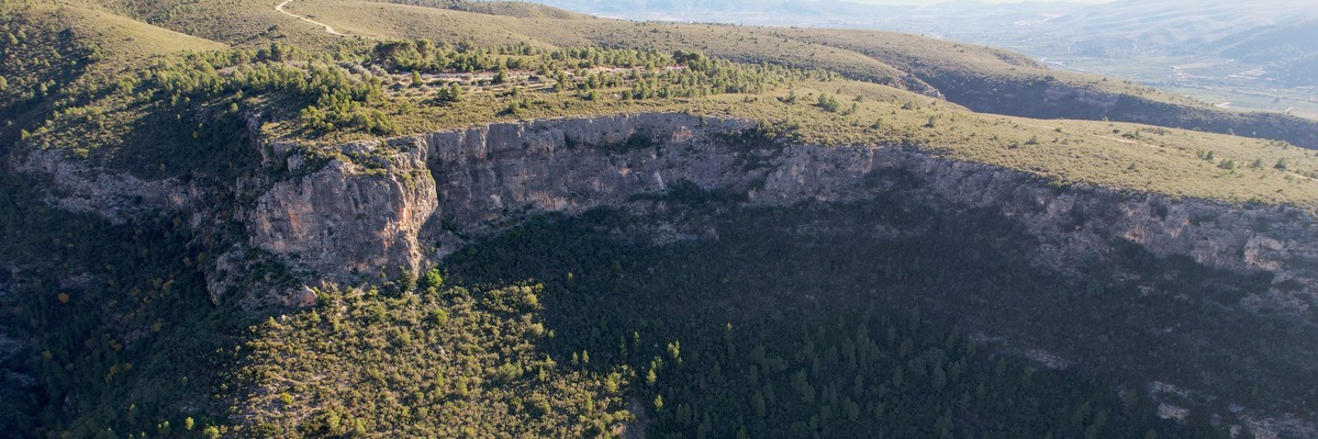
 Small unknown crag in a beautiful setting.
Descrizione
Sole al pomeriggio
nord-ovest
Peñasco orientado al noroeste con vías bastante largas (hasta 40m). La mayoría de las vías están en el rango de dificultad de 5 a 6s bajas. La calidad de la roca, en general, es buena, sin embargo, se pueden encontrar parches de roca suelta o frágil aquí y allá, pero nada de lo que preocuparse realmente.
El pie de vía es bastante inadecuado para los niños. Además de ser incómodo para los niños, existe el riesgo de que se caigan.
No hay reseñas conocidas o publicadas de este lugar. Las vías son entre 20-40m. Si conoces alguna de las vías, por favor, deja un comentario o edítalas directamente. (Mientras tanto unas vías llevan nombre a pie de vía.)
Aquí hay un enlace a un topo antiguo.
North-west facing crag with long routes (up to 40m). The majority of routes are in the 5 to low 6s difficulty range. The rock quality, in general, is good however, patches of loose or brittle rock can be found here and there - but nothing to really worry about.
The base of the crag is quite unsuitable for children. Apart from being uncomfortable for children, there is also a risk of falling down.
There are no known or published topos of this place. If you know any of the routes, please, leave a comment or edit them directly. (In the meantime some routes are named at the foot of the route).
Here is a link to an old topo.
Avvicinamento
Accesso ripido
10-20 minuti
En (39.110566, -0.632871) abandone la carretera principal y gire por una pequeña carretera hacia el valle. Sígala hasta el final para llegar a un aparcamiento ( 39.113742, -0.620730).
Desde el aparcamiento, vuelva a caminar hacia el lugar de donde vino. Después de unos 20-30 metros, un sendero ancho se bifurca a la izquierda. Rápidamente se estrechará hasta convertirse en un sendero pequeño pero claramente visible. Después de unos 15-20 minutos de caminata cuesta arriba llegarás a la base del peñasco.
At (39.110566, -0.632871) leave the main road and turn into a small road into the valley. Follow it till the end to reach a parking (39.113742, -0.620730).
From the parking, walk back towards where you came from. After approx. 20-30 me a wide trail branches off on the left which you should take. It will quickly narrow to a small but clearly visible footpath. After about 15-20 min of an uphill hike, you'll reach the base of the crag.
Etica ereditato da Comunidad Valenciana
Potenziale per nuove vie
- La piedra caliza es blanda - por favor, limpie sus gatos antes de escalar.
- Use su propio material para top-ropes.
- Cepille las vías y el magnesio al terminar la vía.
- Llévese su basura, colillas, y papel higiénico.
- Aparque con consideración y no bloquee pasos de tractores.
- Limestone is soft – please, clean your shoes off dirt before climbing.
- Use your own gear for top-rope set-ups.
- Brush the line and remove all tick marks and chalk excess.
- Pick up rubbish, cigarette butts, and your toilet paper.
- Park considerately and don't block essential laybys or farm access.
Storia
Las primeras vías equipadas por Vicente Lillo sobre las 2000 con colaboración de Ceferino Martinez, Miguel Andreu, Juan Carlos Teruel.
The first routes were bolted by Vicente Lillo around 2000 with the help of Ceferino Martinez, Miguel Andreu, Juan Carlos Teruel.
Pianifica viaggio
Lo sapevi?
Sai che puoi creare un account per registrare e condividere le tue ascensioni? Migliaia di arrampicatori lo stanno già facendo.


Alloggi in zona more Nascondi
Condividi questo
Foto Sfoglia tutte le foto

Dominik su ★★ Sin nombre (9) 6a+ - sn11.jpeg

Dominik su ★★ El diedro del Pere 6a - sn_1.jpeg

Antella - image-1653297082706.png

Mar 25 Apr
Controlla cosa succede a Antella.
Get a detailed insight with a timeline showing
- Ticks by climbers like you
- Discussions of the community
- Updates to the index by our users
- and many more things.
Login to see the timeline!