A Crag Guide gives an extensive view of all sub areas and climbs at a point in the index. It shows a snapshot of the index heirachy, up to 300 climbs (or areas) on a single web page. It shows selected comments climbers have made on a recently submitted ascent.
At a minor crag level this should be suitable for printing and taking with you on a climbing trip as an adjunct to your guidebook.
This guide was generated anonymously. Login to show your logged ascents against each route.
Warning
Rock climbing is extremely dangerous and can result in serious injury or death. Users acting on any information directly or indirectly available from this site do so at their own risk.
This guide is compiled from a community of users and is presented without verification that the information is accurate or complete and is subject to system errors. By using this guide you acknowledge that the material described in this document is extremely dangerous, and that the content may be misleading or wrong. In particular there may be misdescriptions of routes, incorrectly drawn topo lines, incorrect difficulty ratings or incorrect or missing protection ratings. This includes both errors from the content and system errors.
Nobody has checked this particlular guide so you cannot rely on it's accuracy like you would a store bought guide.
You should not depend on any information gleaned from this guide for your personal safety.
You must keep this warning with the guide. For more information refer to our:
Usage policy
Contributors
Thanks to the following people who have contributed to this crag guide:
The size of a person's name reflects their Crag Karma, which is their level of contribution. You can help contribute to your local crag by adding descriptions, photos, topos and more.
Table of contents
- 1.
Mazák
42 in Crag
- 1.1. Horní Mazák 13 in Sector
- 1.2. Dolní Mazák 24 in Sector
- 1.3. Liščí díry / Liščí skály 4 in Sector
- 1.4. Medvědí skála 1 in Sector
- 2. Index by grade
1. Mazák 42 routes in Crag
- Summary:
-
总体而言 传统攀登
Lat / Long: 49.543964, 18.414149
Český horolezecký svaz - Czech Mountaineering Association: Ochrana přírody - Nature protection (czech)
Agentura ochrany přírody a krajiny ČR - Nature and Landscape Protection Agency of the Czech Republic: vyhledávač - search engine (czech)
Agentura ochrany přírody a krajiny ČR - Nature and Landscape Protection Agency of the Czech Republic: mapa - map (czech)
Skalní oblasti ČR: Moisture conditions map, climbing restrictions map (czech)
- principles of sport climbing (climb with the help of your own strength only, don't use artificial aids, etc.)
- principles of first ascents and installing fixed protection
- competence of regional climbing commissions of Czech Mountaineering Association (list)
- prohibition of creating and chopping holds
- which type of removable climbing gear is allowed and don't damaging rock (roped knots, slings, ufos vs. friends, wires, hexes, nuts and cams)
- possibilities of using chalk (strictly prohibited vs. tolerated)
- restrictions resulting from weather conditions (e.g. prohibition of climbing on wet rock (eventually hours or days after rain or during winter)
总结
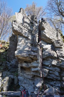
Two fairly separated crags of height about 9-12 meters. Good rock quality. There are several good boulders around too.
描述
 Guidebook - SKÝPALA, Vladimír a Vladimír WOLF a kol., 2018. Moravské skály I: Východní Morava. Valašské Meziříčí: Vladimír Skýpala, 190 s. (sample)
准入问题
 Nature protection
Check current restrictions before you visit crag and be respectful to the nature. Most crags are located in nature protected areas, climbing there is subject to the consent of nature protection authorities and compliance with the conditions set by them. 
 Where to check:
or you can directly ask Czech Mountaineering Association on email info@horosvaz.cz
行为准则
 Rules, principles and standards
Rock climbing in the Czech Republic is regulated by the rules, principles and set of standards for individual areas and crags. Please respect local traditions and rules.
 Accept and make yourself familiar with:
 Rules:
1.1. Horní Mazák 13 routes in Sector
- Summary:
-
所有 传统攀登
Lat / Long: 49.541335, 18.427609
描述
In direct sunight most of the day. The top of the massive is accessible directly from the hiking trail to Lysa hora. The anchors are in a good condition and some new protection was recently added.
前往
Follow the road from Mazak village marked blue up to a crossing with red. Then follow signs to tatranka hut. The massive is located directly next to the hut.
| Route | Grade | Style | Selected ascents | |||||
|---|---|---|---|---|---|---|---|---|
| 1 | Za hranou | 3+ | ||||||
| 2 | Hrana | 5 | 7m | |||||
| 3 | Včelův převis | 7 | 9m, 1 | |||||
 |
||||||||
| Route | Grade | Style | Selected ascents | |||||
| 4 | ★ Kout | 4 | 8m, 1 | |||||
| 5 | Jančíkova | 6 | 9m | |||||
| 6 | Evženka | 7 | 9m, 3 | |||||
| 7 | ★★ Sokolík | 5 | 9m | |||||
| 8 | Velký bachor | 7+ | 9m, 2 | |||||
 |
||||||||
| Route | Grade | Style | Selected ascents | |||||
| 9 | ★★ Pňovka | 5+ | 9m, 1 | |||||
| 10 | ★ Komín | 2 | 8m | |||||
| 11 | ★★ Mičkova | 5+ | 8m | |||||
| 12 | ★★★ Spárka | 4 | 8m | |||||
| 13 | Hrana u chaty | 3 | 8m | |||||
1.2. Dolní Mazák 24 routes in Sector
- Summary:
-
所有 传统攀登
Lat / Long: 49.536346, 18.423575
描述
Completely in shade most of the day.
前往
Its located directly next to the road.
| Route | Grade | Style | Selected ascents | |||
|---|---|---|---|---|---|---|
| 1 | Levá hranka | 4 | 6m | |||
| 2 | Mechová | 3 | 8m | |||
| 3 | Třetí | 3 | 8m | |||
| 4 | Čtvrtá | 4 | 8m | |||
| 5 | Zdeňkova | 4 | 8m | |||
| 6 | Sestupová | 2 | 6m | |||
| 7 | Kominická | 3 | 6m | |||
| 8 | ★★ Kout | 6 | 8m, 1 | |||
| 9 | ★★ Láďova | 6 | 8m, 1 | |||
| 10 | Pavluška | 7- | 8m, 1 | |||
| 11 | Přímá | 6+ | 8m, 1 | |||
| 12 | Varianta | 6 | 8m, 1 | |||
| 13 | Plotnička | 5 | 8m, 1 | |||
| 14 | Fóglí | 4 | 8m | |||
| 15 | Bezejmenná | 4 | 7m | |||
| 16 | Podzimní | 4 | ||||
| 17 | Převísek | 4 | ||||
| 18 | Véčko | 4 | ||||
| 19 | Koutek | 3+ | ||||
| 20 | Stěnka | 4+ | ||||
| 21 | Hamerská | 4+ | 8m | |||
| 22 | Lehčí výstup I | 3 | 8m | |||
| 23 | Lehčí výstup II | 3 | ||||
| 24 | Lehčí výstup III | 3 | ||||
1.3. Liščí díry 4 routes in Sector
- Summary:
-
运动攀岩 和 Bouldering
Lat / Long: 49.538122, 18.414272
描述
Small rocks, circa 4 metres, use as boulder too.
前往
下撤信息
path in blueberry
| Route | Grade | Style | Selected ascents | |||
|---|---|---|---|---|---|---|
| 1 |
Soutěska
boulder 5B/5C nebo klasické lezení s použitím nýtu za vrškem, cesty se dost míchají, těžko rozlišitelné | 5+ | 5m, 1 | |||
| 2 |
Free
podobná jako Soutěska 4/5A nebo klasicky | 5 | 5m, 1 | |||
| 3 |
Urna
Osamělé skalní bloky nazývané Horní nebo Liščí skály II | 5B | ||||
| 4 |
Pilíř
Liščí skály III, pod cestou | 2 | ||||
1.4. Medvědí skála 1 route in Sector
- Summary:
-
所有 传统攀登
Lat / Long: 49.552014, 18.399815
描述
Small rock, 1 bolt, bad quality
前往
| Route | Grade | Style | Selected ascents | |||
|---|---|---|---|---|---|---|
| 1 | Stará / Old | 4 | 1 | |||