A Crag Guide gives an extensive view of all sub areas and climbs at a point in the index. It shows a snapshot of the index heirachy, up to 300 climbs (or areas) on a single web page. It shows selected comments climbers have made on a recently submitted ascent.
At a minor crag level this should be suitable for printing and taking with you on a climbing trip as an adjunct to your guidebook.
This guide was generated anonymously. Login to show your logged ascents against each route.
Warning
Rock climbing is extremely dangerous and can result in serious injury or death. Users acting on any information directly or indirectly available from this site do so at their own risk.
This guide is compiled from a community of users and is presented without verification that the information is accurate or complete and is subject to system errors. By using this guide you acknowledge that the material described in this document is extremely dangerous, and that the content may be misleading or wrong. In particular there may be misdescriptions of routes, incorrectly drawn topo lines, incorrect difficulty ratings or incorrect or missing protection ratings. This includes both errors from the content and system errors.
Nobody has checked this particlular guide so you cannot rely on it's accuracy like you would a store bought guide.
You should not depend on any information gleaned from this guide for your personal safety.
You must keep this warning with the guide. For more information refer to our:
Usage policy
Contributors
Thanks to the following people who have contributed to this crag guide:
Dylan Tubaro
Lee Cujes
Cris
Tom Semple
Tim Haasnoot
Rake
Mattia Fornari
Conor White
Henry McNamee
Jack Colbeck
The size of a person's name reflects their Crag Karma, which is their level of contribution. You can help contribute to your local crag by adding descriptions, photos, topos and more.
部分内容经许可发布自: © Australian Climbing Association Queensland (Creative Commons, Attribution, Share-Alike 2.5 AU)
Table of contents
- 1. The Underworld 9 in Area
- 2. Index by grade
1. The Underworld
- Summary:
-
Lat / Long: -42.137229, 148.320114
准入问题
Many locals continue to use community run website thesarvo.com for crag/route updates and noting any access issues. The associated app can be downloaded and used offline!
http://thesarvo.com/confluence/display/thesarvo/Tasmania
Gerry Narkowicz also produces hardcopy guides to numerous venues across the state via the 'Climb Tasmania' website
前往
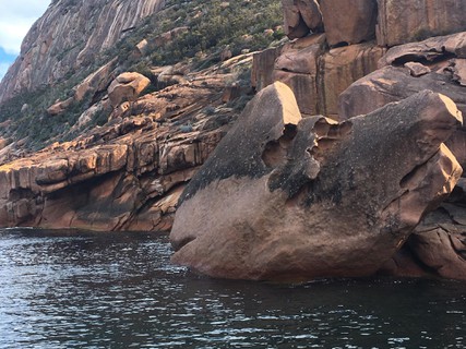
Follow the skyline traverse past the short metal boot-scraping-bridge to a point where the track makes a sharp hairpin-like turn a few hundred metres before the track begins to ascend Mt Parson. From the apex of the turn, veer off towards the sea, gradually heading down to water level. Approach the crag from the south.
行为准则
Crag Stewards
Rock climbers please contact the Crag Steward (freycinet@climbersclubtas.org.au) if you have any queries or concerns regarding social or environmental impacts of rock climbing at this crag.
Do not email regarding general travel, seasonal advice, or lost property - this is not the Steward’s role. If you have important safety information to communicate (e.g. risks due to recent and large rock falls) please also consider updates on thesarvo forum, Facebook group and/or online guidebooks as appropriate. Please copy in cct@climbersclubtas.org.au if you feel you have a high-level concern which may imminently impact the crag or climbing community.
Non-climbers, other users, land managers: please also contact cct@climbersclubtas.org.au if you have important climbing related queries at this location.
Statewide ethics
• The operation and use of drones by park visitors on reserved land including national parks is not permitted
• Peregrine Falcons nest from July - December each year. It’s important that climbers don’t climb near active nests during this period. Known sites (non exhaustive) are: Sand River (Far East, The Panopticon), Bare Rock (R of the Boneyard, L of Bisso of Orange), Rocky Cape, Pubic Wall/Duck Reach, Hillwood, Gunners Quoin, Lowdina.
• Please note that Tasmania has notoriously patchy phone reception for particular service providers. Telstra is the most reliable. An emergency Personal Locator Beacon or similar is recommended kit when climbing in remote locations.
• For more information - follow the link below for some local tips + tricks on how to better reduce your impact during your next Tassie climbing holiday https://www.cragcaretasmania.org.au/learn
| Route | Grade | Style | Selected ascents | |||||
|---|---|---|---|---|---|---|---|---|
| 1 | Corner Part 2 | 18 | 12m | |||||
| 2 | The Wind Below | 26 | 12m | |||||
| 3 | ★★★ Jabberwock | 22 | 27m | |||||
| 4 | ★ Slithy Tove | 24 | 24m | |||||
| 5 | ★★★ Via Magna | 26 | 20m | |||||
| 6 | ★★★ Travels By Dragonfly | 27 | 20m | |||||
| 7 | ★★★ Nunc Dimitis | 24 | 16m | |||||
| 8 | Waters Of Oblivion | 22 | 20m | |||||
 |
||||||||
| Route | Grade | Style | Selected ascents | |||||
| 9 | ★★ Superbrinkmanslip | 22 | 15m | |||||
2. Index by grade
| Grade | Stars | Name | Style | Pop | |
|---|---|---|---|---|---|
| 18 | Corner Part 2 | 12m | |||
| 22 | ★★★ | Jabberwock | 27m | ||
| ★★ | Superbrinkmanslip | 15m | |||
| Waters Of Oblivion | 20m | ||||
| 24 | ★★★ | Nunc Dimitis | 16m | ||
| ★ | Slithy Tove | 24m | |||
| 26 | The Wind Below | 12m | |||
| ★★★ | Via Magna | 20m | |||
| 27 | ★★★ | Travels By Dragonfly | 20m |