A Crag Guide gives an extensive view of all sub areas and climbs at a point in the index. It shows a snapshot of the index heirachy, up to 300 climbs (or areas) on a single web page. It shows selected comments climbers have made on a recently submitted ascent.
At a minor crag level this should be suitable for printing and taking with you on a climbing trip as an adjunct to your guidebook.
This guide was generated anonymously. Login to show your logged ascents against each route.
Warning
Rock climbing is extremely dangerous and can result in serious injury or death. Users acting on any information directly or indirectly available from this site do so at their own risk.
This guide is compiled from a community of users and is presented without verification that the information is accurate or complete and is subject to system errors. By using this guide you acknowledge that the material described in this document is extremely dangerous, and that the content may be misleading or wrong. In particular there may be misdescriptions of routes, incorrectly drawn topo lines, incorrect difficulty ratings or incorrect or missing protection ratings. This includes both errors from the content and system errors.
Nobody has checked this particlular guide so you cannot rely on it's accuracy like you would a store bought guide.
You should not depend on any information gleaned from this guide for your personal safety.
You must keep this warning with the guide. For more information refer to our:
Usage policy
Contributors
Thanks to the following people who have contributed to this crag guide:
Christoph Rauch
Daniel
Alma
Kuba
Dietmar
Anna Straussova
Simon
Hanna
Kajabe
Denis Blum
The size of a person's name reflects their Crag Karma, which is their level of contribution. You can help contribute to your local crag by adding descriptions, photos, topos and more.
Table of contents
- 1. Lug ins Land 13 in Crag
- 2. Index by grade
1. Lug ins Land 13 routes in Crag
- Summary:
-
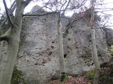
Mostly Sport climbing
Lat / Long: 49.547393, 11.540379
- Zone 1: NO climbing
- Zone 2: climbing on existing routes
- Zone 3: new routes possible
- The limestone is soft – please clean your shoes from dirt in order to avoid polished handholds and steps.
- Don't toprope directly through bolts – use your own material.
- Clean chalk and tickmarks with a brush.
- Don't leave toilet paper.
- Pick up rubbish.
- No unnecessary noise.
- No camp fire and bivvy.
- Park considerately (tractor should be able to pass also at the weekend).
- Smoking in the forests is forbidden from March 1 until October 31 by law.
- No publishing of boulder blocks.
access issues
Seasonal closures for protected birds. See here: Closed crags
Additional information: IG Klettern closure list
Zoning concept
Please respect signs and zoning.
approach
GPS: 11.54025, 49.54739
ethic
 |
||||||||
| Route | Grade | Style | Selected ascents | |||||
|---|---|---|---|---|---|---|---|---|
Nordwand | ||||||||
| 2 | ★ Quietscheentchen | 6- | 12m | |||||
| 3 | ★★ Sid Vicious Gedenkweg | 7 | 12m | |||||
| 4 | ★★ Valerie on my Mind | 7- | 12m | |||||
| 5 | ★★ Susi Sorglos | 6+ | 12m | |||||
Obere Südwand | ||||||||
| 7 | ★★ Retourkutsche | 7 | 12m | |||||
| 8 | ★ Theresa | 6+ | 12m | |||||
| 9 | ★ Landpomeranze | 5- | 12m | |||||
| 10 |
★ Für Elsa und Dani
Set: Dietmar Heidl | 6 | 12m | |||||
Untere Südwand | ||||||||
| 12 |
Böckli
FA: Torsten Scheller, 2018 | 8+ | 3 | |||||
| 13 | ★ Glöckli | 8- | 12m | |||||
| 14 |
Brave Annika
FA: Alma, 2012 | 5+ | 12m | |||||
| 15 | ★ Wilde Amelie | 6 | 12m | |||||
| 16 | ★★ Ossi Bühler Gedenkpfeiler | 6 | 12m | |||||
2. Index by grade
| Grade | Stars | Name | Style | Pop | |
|---|---|---|---|---|---|
| 5- | ★ | Landpomeranze | 12m | ||
| 5+ | Brave Annika | 12m | |||
| 6- | ★ | Quietscheentchen | 12m | ||
| 6 | ★ | Für Elsa und Dani | 12m | ||
| ★★ | Ossi Bühler Gedenkpfeiler | 12m | |||
| ★ | Wilde Amelie | 12m | |||
| 6+ | ★★ | Susi Sorglos | 12m | ||
| ★ | Theresa | 12m | |||
| 7- | ★★ | Valerie on my Mind | 12m | ||
| 7 | ★★ | Retourkutsche | 12m | ||
| ★★ | Sid Vicious Gedenkweg | 12m | |||
| 8- | ★ | Glöckli | 12m | ||
| 8+ | Böckli | 3 |