Showing all 99 nodes.
| Node |
|---|
|
Sagarmatha Nationalpark
The Sagarmatha National Park (sagaramāthā rāṣṭriya nikuñja) is a protected area in the Himalayas of eastern Nepal that is dominated by Mount Everest. It encompasses an area of 443 square miles in the Solukhumbu District. In the north, it shares the international border with the Qomolangma National Nature Preserve of Tibet and extends to the Dudh Kosi river in the south. Adjacent to the east is the Makalu Barun National Park. The park contains the upper catchment areas of the Dudh Kosi river, Bhotekoshi river basin and the Gokyo Lakes. It is largely composed of rugged terrain and gorges of the high Himalayas, including the world's highest peak Sagarmatha (Mt. Everest). Other peaks above 20,000 feet are Lhotse, Cho Oyu, Cholatse, Thamserku, Nuptse, Amadablam and Pumori. |
|
Thame Teng
High altitude climbing above Thame Theng in the Khubu region of Nepal. 1-4 pitches, grades 4+ to 7a. Stunning location with views of many major Himalayan peaks. Access via the trekking route from Lukla through Namche Bazaar to Thame. Picture. It is a site located in the eastern part of Nepal in Thame village of Everest region elevating up to 3800m. In this rock climbing site, there are more than 17 different routes which are starting from 4c to 7c multi-pitch 200m height. The village in which this rock climbing site is located, Thame, is also famous as it is the birthplace legendary mountain climbers, Apa Sherpa, and Tenzing Norgay. |
| Thame Teng |
|
6b
1
Trekking permit required to enter Sagamartha national park. As of 2018 a peak permit is required to climb above 5,800m - although only a set list of mountains can be legally climbed. |
|
6a
2
Enjoyable climbing though a bit dirty. Bridge up the initial corner then move out on the arete. |
|
7a
3
Trekking permit required to enter Sagamartha national park. As of 2018 a peak permit is required to climb above 5,800m - although only a set list of mountains can be legally climbed. |
|
3b
4
Partially bolted. The gully can be used as a walk-off from the lower routes. |
|
4c
5
Easy up the arête. |
|
5b
6
Easy, but long and exposed traverse. |
|
5c
7
Trekking permit required to enter Sagamartha national park. As of 2018 a peak permit is required to climb above 5,800m - although only a set list of mountains can be legally climbed. |
|
5b
8
Up the slab traversing right to the middle line of bolts. First anchor a few meters before the end of the slab up the route slightly right of the bolt line. One additional anchor only 5m off the ground, just after the traverse. |
|
6b
9
Beautiful vertical climbing. |
|
4c
10
Trekking permit required to enter Sagamartha national park. As of 2018 a peak permit is required to climb above 5,800m - although only a set list of mountains can be legally climbed. |
|
5c
11
Up the last part of the slap, then slightly overhanging on good holds to the top. |
|
5c
12
Trekking permit required to enter Sagamartha national park. As of 2018 a peak permit is required to climb above 5,800m - although only a set list of mountains can be legally climbed. |
|
13
Trekking permit required to enter Sagamartha national park. As of 2018 a peak permit is required to climb above 5,800m - although only a set list of mountains can be legally climbed. |
|
14
Trekking permit required to enter Sagamartha national park. As of 2018 a peak permit is required to climb above 5,800m - although only a set list of mountains can be legally climbed. |
|
15
Trekking permit required to enter Sagamartha national park. As of 2018 a peak permit is required to climb above 5,800m - although only a set list of mountains can be legally climbed. |
|
16
Trekking permit required to enter Sagamartha national park. As of 2018 a peak permit is required to climb above 5,800m - although only a set list of mountains can be legally climbed. |
|
17
Trekking permit required to enter Sagamartha national park. As of 2018 a peak permit is required to climb above 5,800m - although only a set list of mountains can be legally climbed. |
|
Monjo
Town on the way to Everest base camp. You reach it prior to getting to Namche Bazaar. About a days walk form Lukla airport. Wall is located five minutes from park entrance on the left. Can't miss it. You walk down the path and the stairs/slope it will be on the left. There are 3 short routes. All bolted all short. I think seven bolts and anchos max if I remember correctly. All could be extended to be over 35m long. When we were climbing an old lady tried to extort a 1000 rupees from us but we did not pay. |
| Monjo |
|
6c+
Monju
According to the army at the checkpoint in Monjo, you need permission from the military base in Namche Bazaar to climb here as it is a military area. |
|
5b
No Name 1
According to the army at the checkpoint in Monjo, you need permission from the military base in Namche Bazaar to climb here as it is a military area. |
|
5b
No Name 2
According to the army at the checkpoint in Monjo, you need permission from the military base in Namche Bazaar to climb here as it is a military area. |
|
8a
Way to Monjo
Extension of "No Name 2". |
|
JP
According to the army at the checkpoint in Monjo, you need permission from the military base in Namche Bazaar to climb here as it is a military area. |
|
Under the big mountain
According to the army at the checkpoint in Monjo, you need permission from the military base in Namche Bazaar to climb here as it is a military area. |
|
Deporte libre
According to the army at the checkpoint in Monjo, you need permission from the military base in Namche Bazaar to climb here as it is a military area. |
|
The Beast
According to the army at the checkpoint in Monjo, you need permission from the military base in Namche Bazaar to climb here as it is a military area. |
| 5c Center Route |
| 6c/c+ Jak Attack |
| 6a Monjo Hand Crack |
| 5b Right Side Route |
|
Kohanar
Sunny rock climbing at 4.000m! Located in Kohanar/Konar there are a couple of more moderate routes than what you can find at the North Face crag near Phortse. 4 rock routes, one ice climb, and room for more! Fairly secluded from winds. |
| Kohanar |
|
5c
Unnamed
To the left of the Yes & No climbs, there is another climb. I have not done it, not too sure. Check it out. Climb it. Looks like it is as hard as Yes, or maybe a little harder. Left of the main wall |
|
6a
Yes
Little harder than "No," but maybe that was due to the altitude. Little thinner holds, funkier movements. Named "Yes" because the other one is named "No". 5 or 6 draws. Shares the anchor with "No" |
|
5b
No
Not sure of the true name, but when we were there after KCC ended, "No" was written in chalk at the base. Therefore we're calling it "No". Sorta awkward movement to some not so awkward movement, might be the altitude though. Left most route of the Kohanar Climbs. Not sure of the true name, but when we were there after KCC ended, "No" was written in chalk at the base. Therefore we're calling it "No". Sorta awkward movement to some not so awkward movement, might be the altitude though. |
|
5b
Fun Crack Jam Snack
Photo. A weird, finger crack that doesn't really require much jamming to climb. But also has good jams. It can be TR'd, but it is funky awkward and better to just climb it than go around to get to the anchor. Probably not the real name of the climb. Around the corner to the right from the main wall. |
|
6a+
Overhanging Crack
Around the corner from "Fun Crack Jam Snack" is a overhanging crack. Didn't climb it, bootied a cam on it, Conrad says it's fun. Up a ways to the right from Fun Crack Jam Snack. #.5-#3 cams or somewhere in there. Nuts would maybe help too. |
|
Mt. Everest Area Bouldering
The expansive area starts in Lukla and goes all the way to Everest Base Camp. A lifetime of boulders that get cleaner the higher you go. Sectors: Machermo (on way to Gyokyo), Dingboche (on way to EBC - awesome but limited), and the EBC area. Chalk is evident on numerous rocks in the area, but expect to clean the really good lines. |
| Mt. Everest Area Bouldering |
|
Machermo
On the way to Gyokyo. |
| Mt. Everest Area Bouldering Machermo |
|
1
Trekking permit required to enter Sagamartha national park. As of 2018 a peak permit is required to climb above 5,800m - although only a set list of mountains can be legally climbed. |
| Mt. Everest Area Bouldering |
|
Dingboche
On way to EBC - awesome but limited. |
| Mt. Everest Area Bouldering Dingboche |
|
1
Trekking permit required to enter Sagamartha national park. As of 2018 a peak permit is required to climb above 5,800m - although only a set list of mountains can be legally climbed. |
| Mt. Everest Area Bouldering |
|
ECB Area
Trekking permit required to enter Sagamartha national park. As of 2018 a peak permit is required to climb above 5,800m - although only a set list of mountains can be legally climbed. |
| Mt. Everest Area Bouldering ECB Area |
|
1
Trekking permit required to enter Sagamartha national park. As of 2018 a peak permit is required to climb above 5,800m - although only a set list of mountains can be legally climbed. |
| Mt. Everest Area Bouldering |
| 1 |
|
Cho Oyu
Cho Oyu (Nepali: चोयु; Tibetan: ཇོ་བོ་དབུ་ཡ) is the sixth-highest mountain in the world at 8,188 metres (26,864 ft) above sea level. Cho Oyu means "Turquoise Goddess" in Tibetan. The mountain is the westernmost major peak of the Khumbu sub-section of the Mahalangur Himalaya 20 km west of Mount Everest. The mountain stands on the China–Nepal border. |
| Cho Oyu |
|
North-West Ridge
Trekking permit required to enter Sagamartha national park. As of 2018 a peak permit is required to climb above 5,800m - although only a set list of mountains can be legally climbed. |
|
Polish Route
Trekking permit required to enter Sagamartha national park. As of 2018 a peak permit is required to climb above 5,800m - although only a set list of mountains can be legally climbed. |
|
Austrian Route
Trekking permit required to enter Sagamartha national park. As of 2018 a peak permit is required to climb above 5,800m - although only a set list of mountains can be legally climbed. |
|
Mera Peak
The Highest of the "treking peaks" note high altitude and basic ice climbing skills required 6476m. More secluded than the more popular trekking/climbing peaks along the route to Everest base camp (e.g. Imja Tse/Island Peak) with scenery that is just as good if not better. Many villages with guest houses along the way but be prepared to be self sufficient (provide your own food & shelter) in the event that you arrive in a village and there is no room at a guest house. Having a local guide is recommended as the route (particularly the beginning) is not straightforward. Above Khare on the Mera La, crampons are necessary. During peak climbing season (Sept-Nov and Apr-May) there is likely a boot pack to follow all the way up the Mera La and to the summit. However, keep in mind that the altitude and mountain weather can always pose challenges to even the most experienced of climbers. Weather can be variable and crevasse danger exists above Mera high camp. Traveling in roped teams highly suggested above high camp. |
| Mera Peak |
|
PD
★★ Summit
Summit: 6476m |
|
Island Peak
Down the hill from Everest, 6189m. Island peak is viewable from Chhukung and there are signs pointing to the trail as you leave town. The peak can be approached easily through an obvious trail that crosses a series of rocky stream beds from south. When you initially see the peak from the southeast, you need to continue around it, keeping the peak to the north of you as you progress toward lake Imja Tse. This means keeping the peak to your left and base camp is near the latrines. There is an option for a high camp at ~17,500 which follows the trail (see south face description) to a higher plateau. An alpine start around 2am is reasonable, depending on fitness level and weather conditions. Typically, winds begin to get pretty fierce around 10am, which means that descent should be underway by then. |
| Island Peak |
|
PD
★★★ Normal route
Trekking peak permit required Summiting Requires Permit and NMA Certified Guide. You can trek in the region for free, but a summit requires you to hire a guide certified through the Nepal Mountaineering Association which varies in price seasonally and depending on company. |
| F South Face |
|
Ama Dablam
Summit : 6812m |
| Ama Dablam |
|
D
★★★ SW Arete
Trekking permit required to enter Sagamartha national park. As of 2018 a peak permit is required to climb above 5,800m - although only a set list of mountains can be legally climbed. |
|
TD
Lagunak Route
Trekking permit required to enter Sagamartha national park. As of 2018 a peak permit is required to climb above 5,800m - although only a set list of mountains can be legally climbed. |
|
Lobuche East
6120m |
| Lobuche East |
|
AI4 WI5+ M7 VI
Night Terror
A permit to climb the mountain is required from the National Mountaineering Association (NMA) of Nepal, which classifies Lobuche East (6,119m) as a "trekking peak", and Lobuche West (6,145m) as an "expedition peak". |
|
6b A2 M4
Le Quatuor à cordes
A permit to climb the mountain is required from the National Mountaineering Association (NMA) of Nepal, which classifies Lobuche East (6,119m) as a "trekking peak", and Lobuche West (6,145m) as an "expedition peak". |
|
Nirekha Peak
Nirekha is in the Mahalangur Region, deep in the Himalayas, close to the Tibetan border and hidden among the well-known giants of Everest, Cho Oyu, and Cholatse. |
| Nirekha Peak |
|
AD
★★★ Normalroute über den Cho La Col
Lokation : 27.977478°, 86.762703° Höhe: 6159 m |
|
Minmo Khola Valley
Trekking permit required to enter Sagamartha national park. As of 2018 a peak permit is required to climb above 5,800m - although only a set list of mountains can be legally climbed. |
| Minmo Khola Valley |
|
WI4
No Place for Ferrets
Trekking permit required to enter Sagamartha national park. As of 2018 a peak permit is required to climb above 5,800m - although only a set list of mountains can be legally climbed. |
|
WI4+
Little Weasel
Trekking permit required to enter Sagamartha national park. As of 2018 a peak permit is required to climb above 5,800m - although only a set list of mountains can be legally climbed. |
|
WI3+
Stroke of Genius
Trekking permit required to enter Sagamartha national park. As of 2018 a peak permit is required to climb above 5,800m - although only a set list of mountains can be legally climbed. |
|
WI5
Ukraina-ko baliyo
Trekking permit required to enter Sagamartha national park. As of 2018 a peak permit is required to climb above 5,800m - although only a set list of mountains can be legally climbed. |
|
WI5
Sunflower
Trekking permit required to enter Sagamartha national park. As of 2018 a peak permit is required to climb above 5,800m - although only a set list of mountains can be legally climbed. |
|
WI3+
Heart Throb
Trekking permit required to enter Sagamartha national park. As of 2018 a peak permit is required to climb above 5,800m - although only a set list of mountains can be legally climbed. |
|
WI5
Standard Route
Trekking permit required to enter Sagamartha national park. As of 2018 a peak permit is required to climb above 5,800m - although only a set list of mountains can be legally climbed. |
|
Lunag Ri
The Lunag Ri is a mountain in the Himalayas in the mountain group Rolwaling Himal. |
| Lunag Ri |
|
Lama-Solo
Trekking permit required to enter Sagamartha national park. As of 2018 a peak permit is required to climb above 5,800m - although only a set list of mountains can be legally climbed. |
| Boulder |
|
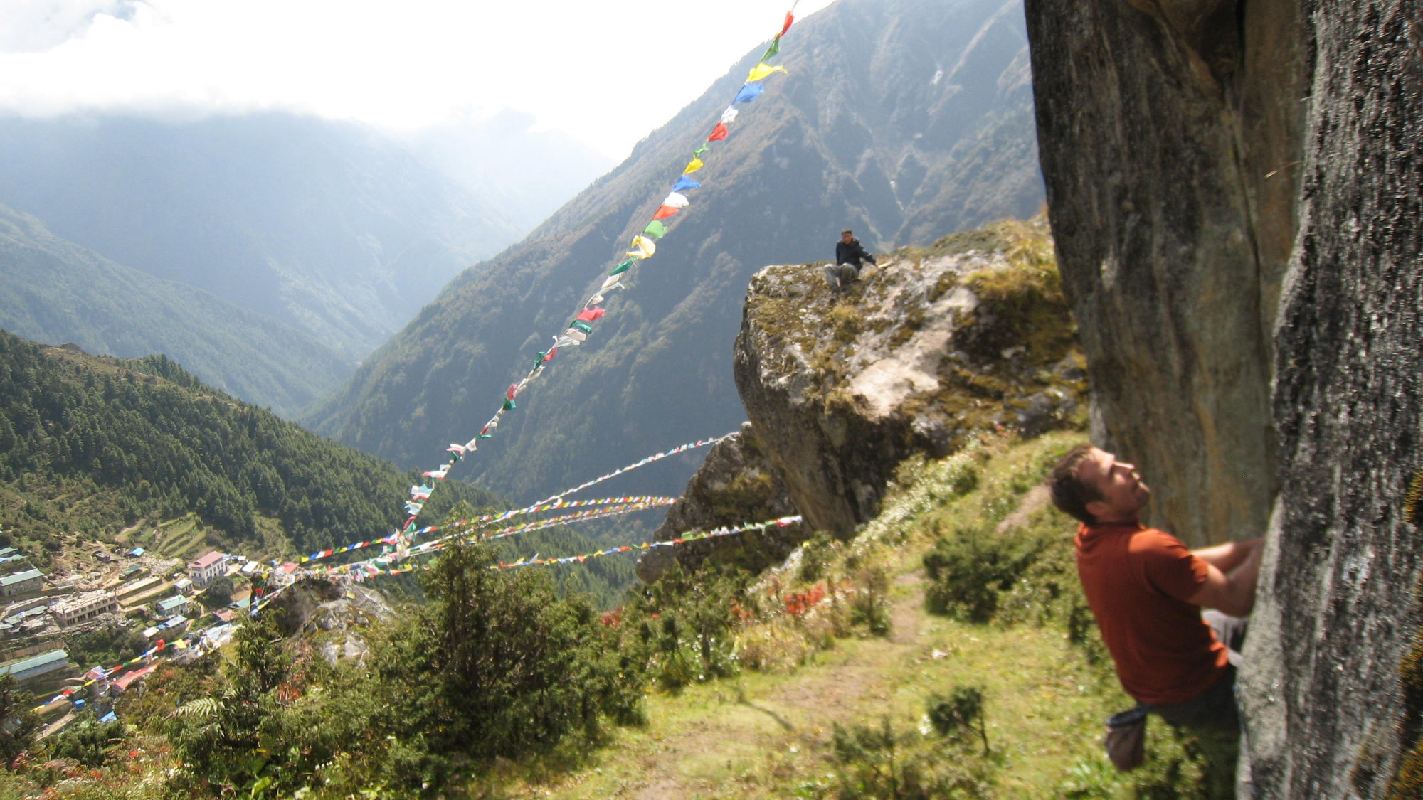
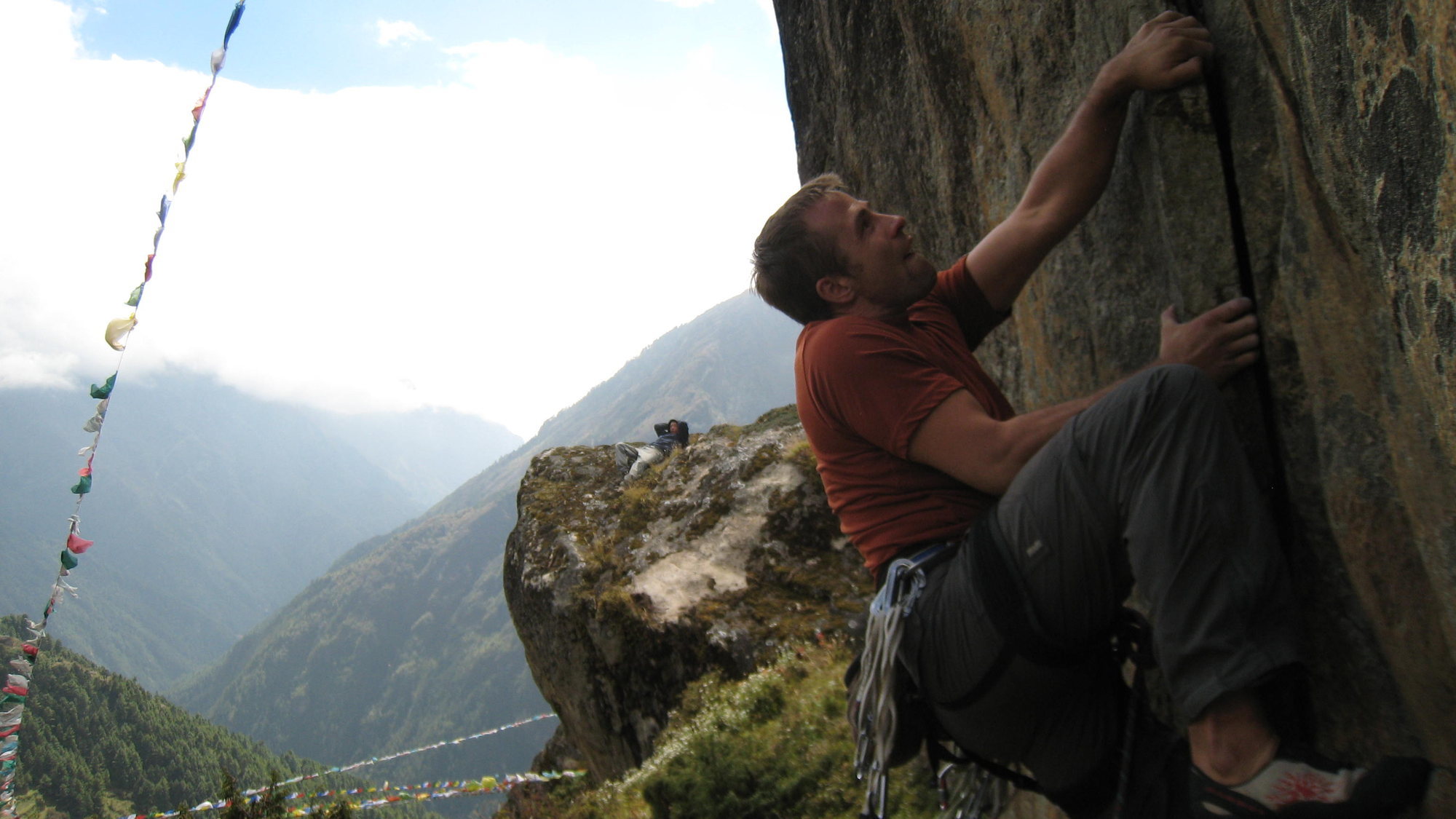
Namche Bazar
This is the largest town on the Everest trek. 3 (or more?) sport routes on the rocks above the city. They are easy to find. There are also a lot of possibilities for bouldering on scattered boulders and treks around. |
| Namche Bazar |
|
6a
Mo Mo Jam
Above Namche Bazaar. Further up and to the right of the Sunshine Lodge boulder. Left Route. 3 bolts to a hand jam and larger crack. #2-3 cam would be helpful. No anchors. Walk off. Picture. |
|
6a
Right Route
Above Namche Bazaar. Further up and to the right of the Sunshine Lodge boulder. Right Route. Three bolts to hand and larger crack. No anchors. Walk off. Picture. |
|
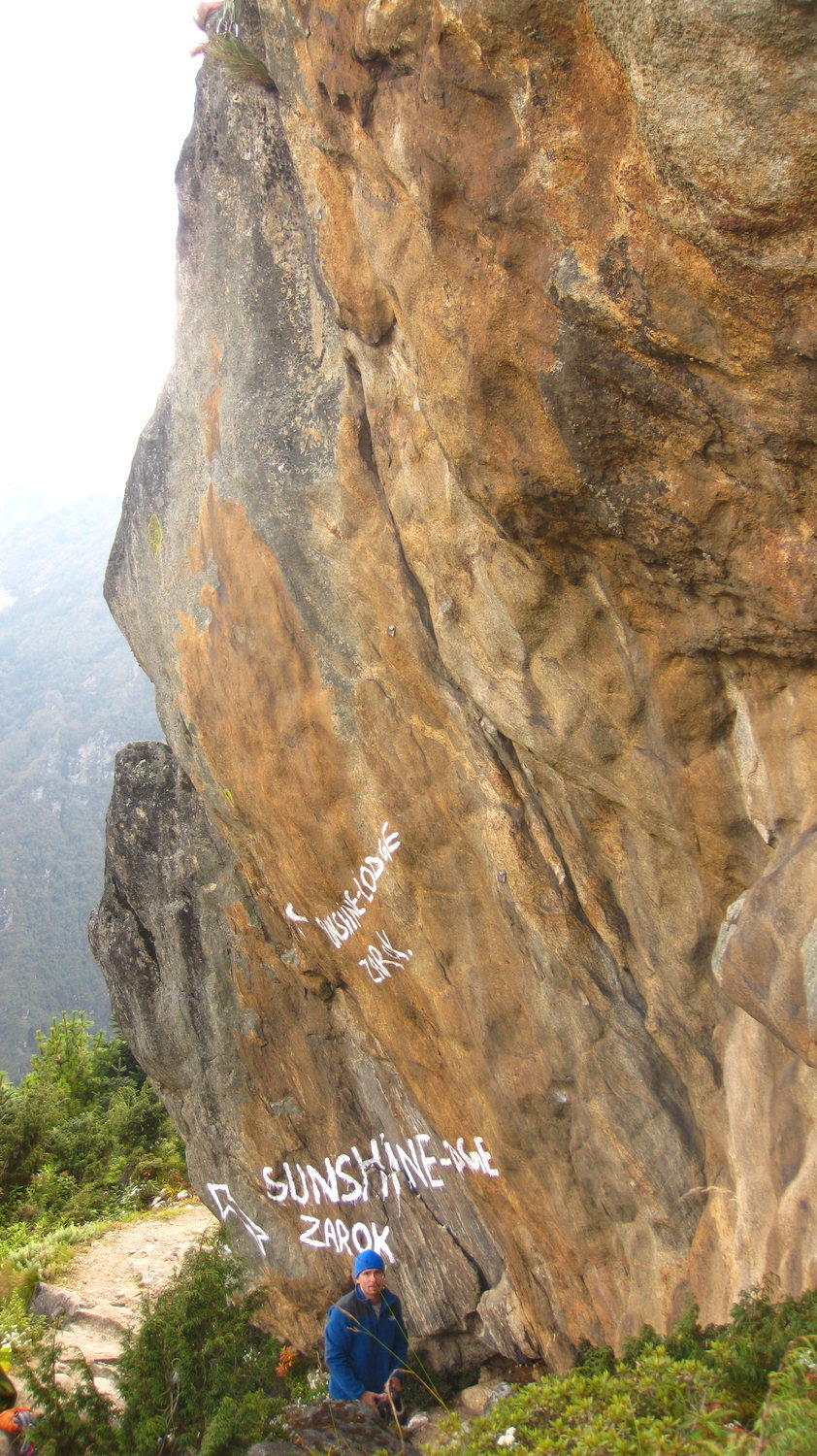
7b
Route on Sunshine Lodge Sign Boulder
On the way to Sunshine lodge there is a boulder with a painted on Sunshine lodge sign. Its on the right side of the boulder. It has some chipped holds but looks great. Topo. |
| Boulder |
|
V0+
200 rupee squeezy toothpaste
Boulder just before Namche helipad. Have fun squeezing and squirming. Finish by grabbing the lip at the right block (when facing the boulder) 4m up, but avoid pulling yourself past the lip and topping out which would damage the lichen. |
|
V0
50 rupee butter biscuits
Slightly tricky to get established, and a nice little topout. Downclimb after climbing as there is a stone fence just above the top out. Boulder just after Namche helipad, below a building |
| Kongde Ri Ice Climbs |
| Kongde Ri Ice Climbs |
|
WI5
Losar
Trekking permit required to enter Sagamartha national park. As of 2018 a peak permit is required to climb above 5,800m - although only a set list of mountains can be legally climbed. |
|
WI5
Shaugdro
Trekking permit required to enter Sagamartha national park. As of 2018 a peak permit is required to climb above 5,800m - although only a set list of mountains can be legally climbed. |
|
WI4+
Power House Bowl 1
Trekking permit required to enter Sagamartha national park. As of 2018 a peak permit is required to climb above 5,800m - although only a set list of mountains can be legally climbed. |
|
WI4+
Power House Bowl 2
Trekking permit required to enter Sagamartha national park. As of 2018 a peak permit is required to climb above 5,800m - although only a set list of mountains can be legally climbed. |
|
WI3+
Power House Bowl 3
Trekking permit required to enter Sagamartha national park. As of 2018 a peak permit is required to climb above 5,800m - although only a set list of mountains can be legally climbed. |
|
Cholatse
Cholatse (also known as Jobo Lhaptshan) is a mountain in the Khumbu region of the Nepalese Himalaya. Cholatse is connected to Taboche (21,328 feet) by a long ridge. The Chola glacier descends off the east face. The north and east faces of Cholatse can be seen from Dughla, on the trail to Mount Everest base camp. There is a lake just below this pass to the east, and in Tibetan 'cho' is lake, 'la' is pass, and 'tse' is peak so Cholatse means literally "lake pass peak".[2] Cholatse was first climbed via the southwest ridge on April 22, 1982 by Vern Clevenger, Galen Rowell, John Roskelley and Bill O'Connor. The north face was successfully scaled in 1984. |
| Cholatse |
|
A1 - 2 WI2+ M3/4
Southwest Ridge
WI2+ M3-4 A1-2 Steep Snow. |
|
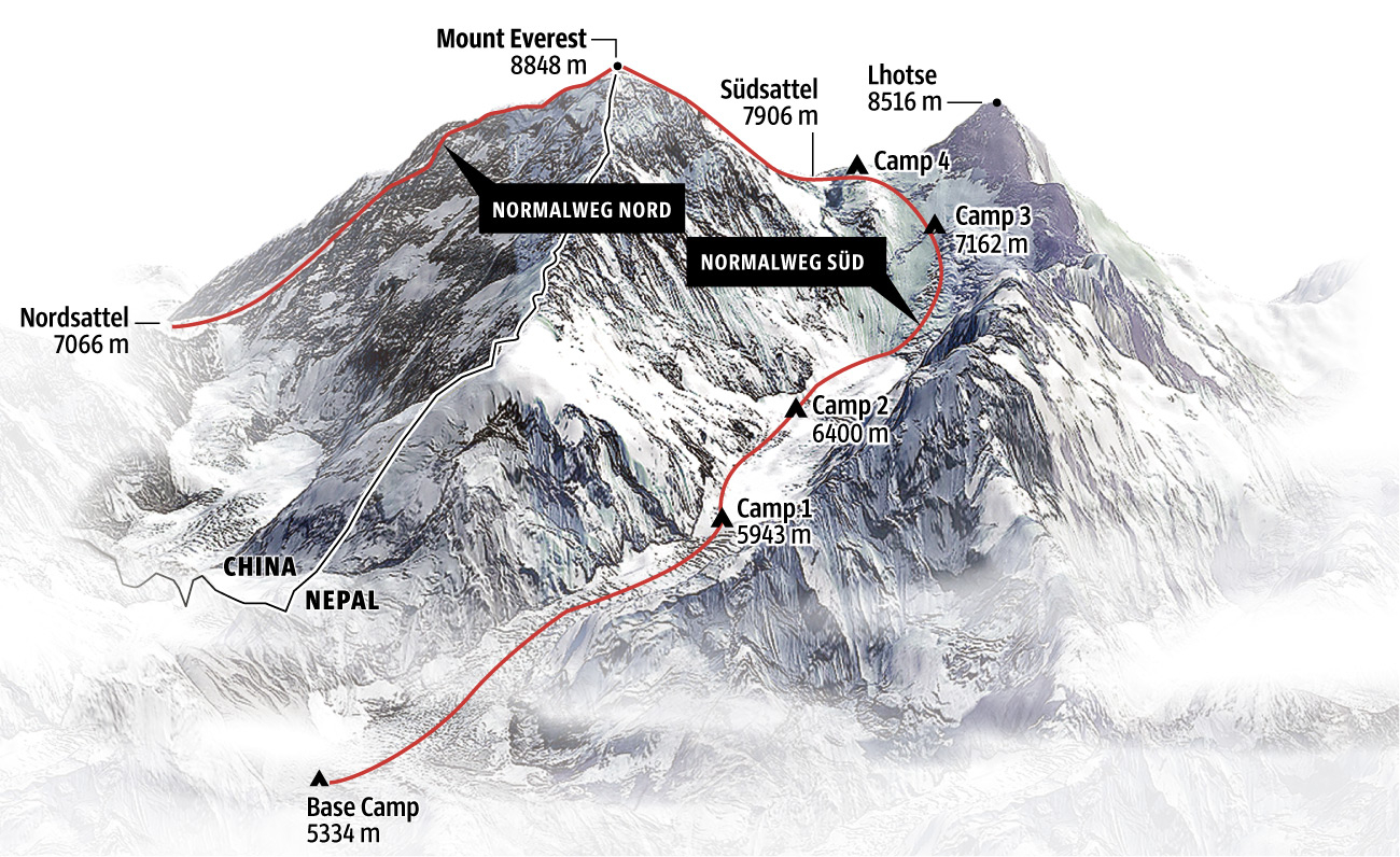
Mt Everest
The highest chunk of land on the planet. |
| Mt Everest |
| [Topo](https://gfx.sueddeutsche.de/apps/563a2a8597842dd02fe1dfec/mobile/data/assets/maps_0_imageUrl. |
|
Normal Route South
Trekking permit required to enter Sagamartha national park. As of 2018 a peak permit is required to climb above 5,800m - although only a set list of mountains can be legally climbed. |
|
Normal Route North
Trekking permit required to enter Sagamartha national park. As of 2018 a peak permit is required to climb above 5,800m - although only a set list of mountains can be legally climbed. |
|
Shomare
Boulders just after the village of Shomare (village after Pangboche) on the way to Everest base camp |
| Shomare |
|
V2
★ Daal Baht Power 24 Hour
Boulder outside Shomare, 75m from lodge. Good landing. Start from chest height on sharp crimp and sloper crimp. Get established, then powerful move to 2 decent holds at head height. Continue up and topout (arete is on). You can downclimb the backside at V0 |
|
Mahalangur Himal
A small area for bouldering during acclimatizations and trekkings in the valley with awesome views on high alpine objectives |
| Mahalangur Himal |
|
5C
★★ Flores
A huge block standing alone on a sunny terrace, with views down to the Gokyo village and the blue lake. Perfect for a warmup with good views. Heel Hook to top out |
|
4C
★ Toilet Boulder
A rather small but funny boulder just next to the huts in the Gokyo Village entrance trail. |
|
5B
★ Seitentänzer
Short but sweet boulder next to the Porters lodge. Good for some movement in-between treks |
Showing all 99 nodes.