Estacionalidad
Descripción
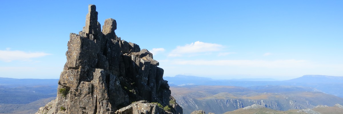
Adventure Climbing on the Cradle Mountain massif.
Restricciones
Located within the Cradle Mountain National Park, so all relevant restrictions apply
Acceso
Cradle Mountain is located approximately 90 minutes walk from the Dove Lake carpark within Cradle Mountain National Park. The nearest major town is Devonport, approximately one hour away.
Ética
Crag Stewards
Rock climbers please contact the Crag Steward (southwest@climbersclubtas.org.au) if you have any queries or concerns regarding social or environmental impacts of rock climbing at this crag.
Do not email regarding general travel, seasonal advice, or lost property - this is not the Steward’s role. If you have important safety information to communicate (e.g. risks due to recent and large rock falls) please also consider updates on thesarvo forum, Facebook group and/or online guidebooks as appropriate. Please copy in cct@climbersclubtas.org.au if you feel you have a high-level concern which may imminently impact the crag or climbing community.
Non-climbers, other users, land managers: please also contact cct@climbersclubtas.org.au if you have important climbing related queries at this location.
Statewide Ethics
• The operation and use of drones by park visitors on reserved land including national parks is not permitted
• Peregrine Falcons nest from July - December each year. It’s important that climbers don’t climb near active nests during this period. Known sites (non exhaustive) are: Sand River (Far East, The Panopticon), Bare Rock (R of the Boneyard, L of Bisso of Orange), Rocky Cape, Pubic Wall/Duck Reach, Hillwood, Gunners Quoin, Lowdina.
• Please note that Tasmania has notoriously patchy phone reception for particular service providers. Telstra is the most reliable. An emergency Personal Locator Beacon or similar is recommended kit when climbing in remote locations.
• For more information - follow the link below for some local tips + tricks on how to better reduce your impact during your next Tassie climbing holiday https://www.cragcaretasmania.org.au/learn
Historia
Gráfico cronológico de las vías
The first recorded ascent of the Skyline Ridge Traverse was made over a century ago, though much of the scrambling has gone unrecorded.
Planifica tu viaje
¿Lo sabías?
¿Sabías que puedes crear una cuenta para registrar, monitorizar y compartir tus ascensiones? Hay miles de escaladores y escaladoras que lo hacen.


Selected Guidebooks more Ocultar
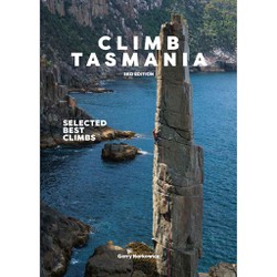
Autor(es): Gerry Narkowicz
Fecha: 2021
número ISBN: 9780646841946
Cracks, sea stacks, big walls, remote exotic locations, volcanic columns, no crowds and your choice of the predominant dolerite, some quartzite and a little sandstone to remind you of the mainland. Many a wilderness climbing experience can be had within a 2hr car trip from the main centers. By Gerry Narkowicz. This guide features 1280 routes.
ⓘ
Alojamientos cercanos more Ocultar
Compartir contenido
Fotos Navegar por todas las fotos
/0f/66/0f66653d7964cf1d30f2d0e9d7a87a6c8648fee3)
zac en Cradle Mountain - IMG_2902.JPG
/98/4f/984fdbbababd119c24484a1c51b3059737c1db9d)
★★★ Skyline Traverse 3 - IMG_5314.JPG
/f1/b3/f1b33d219da75bee6c476d6af81b52b5ca9955a6)
Daniel Razzino en Cradle Mountain - IMG_4539.JPG

Andrew Serack en ★★★ Skyline Traverse 3 - C32812FF-7438-4CA7-B0E8-DD568C3AFF6D.jpeg
Mié 24 Mayo
Echa un vistazo a lo que está ocurriendo en Cradle Mountain.
Get a detailed insight with a timeline showing
- Ticks by climbers like you
- Discussions of the community
- Updates to the index by our users
- and many more things.
Login to see the timeline!