A Crag Guide gives an extensive view of all sub areas and climbs at a point in the index. It shows a snapshot of the index heirachy, up to 300 climbs (or areas) on a single web page. It shows selected comments climbers have made on a recently submitted ascent.
At a minor crag level this should be suitable for printing and taking with you on a climbing trip as an adjunct to your guidebook.
This guide was generated anonymously. Login to show your logged ascents against each route.
Warning
Rock climbing is extremely dangerous and can result in serious injury or death. Users acting on any information directly or indirectly available from this site do so at their own risk.
This guide is compiled from a community of users and is presented without verification that the information is accurate or complete and is subject to system errors. By using this guide you acknowledge that the material described in this document is extremely dangerous, and that the content may be misleading or wrong. In particular there may be misdescriptions of routes, incorrectly drawn topo lines, incorrect difficulty ratings or incorrect or missing protection ratings. This includes both errors from the content and system errors.
Nobody has checked this particlular guide so you cannot rely on it's accuracy like you would a store bought guide.
You should not depend on any information gleaned from this guide for your personal safety.
You must keep this warning with the guide. For more information refer to our:
Usage policy
Contributors
Thanks to the following people who have contributed to this crag guide:
Brendan Heywood
Tommy Krauss
o_g
Chris L
Tim Othy
Nick Hanson
Kallan Lauritsen
Marco McLean
Lewis Traill
Tom Reid
The size of a person's name reflects their Crag Karma, which is their level of contribution. You can help contribute to your local crag by adding descriptions, photos, topos and more.
Table of contents
- 1. The Yellow Cave (Dry) 7 in Area
- 2. Index by grade
1. The Yellow Cave (Dry) 7 routes in Area
- Summary:
-
모두 볼더링
Lat / Long: -42.306259, 147.381969
설명
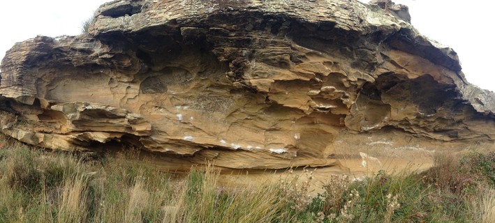
First cave about 20m left of the bottom dam. Dry in even fierce bad weather.
접근 문제들
Many locals continue to use community run website thesarvo.com for crag/route updates and noting any access issues. The associated app can be downloaded and used offline!
http://thesarvo.com/confluence/display/thesarvo/Tasmania
Gerry Narkowicz also produces hardcopy guides to numerous venues across the state via the 'Climb Tasmania' website
접근
Approach via the bottom dam, Yellow Cave is the first cave left, about 20m from the dam.
윤리문제
Crag Stewards
Rock climbers please contact the Crag Steward (oatlands@climbersclubtas.org.au) if you have any queries or concerns regarding social or environmental impacts of rock climbing at this crag.
Do not email regarding general travel, seasonal advice, or lost property - this is not the Steward’s role. If you have important safety information to communicate (e.g. risks due to recent and large rock falls) please also consider updates on thesarvo forum, Facebook group and/or online guidebooks as appropriate. Please copy in cct@climbersclubtas.org.au if you feel you have a high-level concern which may imminently impact the crag or climbing community.
Non-climbers, other users, land managers: please also contact cct@climbersclubtas.org.au if you have important climbing related queries at this location.
Other
• The operation and use of drones by park visitors on reserved land including national parks is not permitted
• Peregrine Falcons nest from July - December each year. It’s important that climbers don’t climb near active nests during this period. Known sites (non exhaustive) are: Sand River (Far East, The Panopticon), Bare Rock (R of the Boneyard, L of Bisso of Orange), Rocky Cape, Pubic Wall/Duck Reach, Hillwood, Gunners Quoin, Lowdina.
• Please note that Tasmania has notoriously patchy phone reception for particular service providers. Telstra is the most reliable. An emergency Personal Locator Beacon or similar is recommended kit when climbing in remote locations.
• For more information - follow the link below for some local tips + tricks on how to better reduce your impact during your next Tassie climbing holiday https://www.cragcaretasmania.org.au/learn
 |
||||||||
| Route | Grade | Style | Selected ascents | |||||
|---|---|---|---|---|---|---|---|---|
| 1 |
★ Un-named
SDS under roof left of Sanguine Direct. Out, around bulge to finish on the same jug hold as Sanguine Direct. | V2 | 4m | |||||
| 2 |
★★ Sanguine Direct
Direct SDS to Sanguine. Start under roof, moving through slopers on the face. The finish is the same as Sanguine | V3 | 4m | |||||
| 3 |
★★★ Sanguine
R to L traverse of sloper rail, finishing up to jug under roof. Great rock. | V4 | 6m | |||||
| 4 |
★ Roundhouse
Start as for Sanguine, but move up then left on slopes and pinches. Finish on jug. | V7 | 5m | |||||
| 5 |
★★ Strongbuoy / Roundhouse Direct
Start roughly in the middle of the Sanguine traverse, directly under the roof pocket on slopers, bust straight up and finish as for Roundhouse. FA: Tim Othy, 1월 2022 | V8 | 3m | |||||
| 6 |
★★ Roundhouse - Roof pocket variant
Variation: Out of confusion as to exactly where Roundhouse goes, most people tend to do the slightly easier 'Roof-Pocket' variation which uses the big roof pocket instead of the slopes and pinches. This variation goes at around V5 | V5 | 5m | |||||
| 7 |
★ V6
Hang start on low ledge with your heel up. Move right along the line for a couple of metres to finish on jug. The extension through the lip and top out would probably go. | V6 | 4m | |||||
2. Index by grade
| Grade | Stars | Name | Style | Pop | |
|---|---|---|---|---|---|
| V2 | ★ | Un-named | 4m | ||
| V3 | ★★ | Sanguine Direct | 4m | ||
| V4 | ★★★ | Sanguine | 6m | ||
| V5 | ★★ | Roundhouse - Roof pocket variant | 5m | ||
| V6 | ★ | V6 | 4m | ||
| V7 | ★ | Roundhouse | 5m | ||
| V8 | ★★ | Strongbuoy | 3m |