Use this Region Guide to easily find and compare Crags.
Table of contents
- 1.
Südtirol / South Tyrol / Alto Adige
5213 in Region
-
1.1.
Val Pusteria / Pustertal 532 in Region
- 1.1.1. Zillertaler Alpen / Alpi della Zillertal 282 in Region
- 1.1.2. Rieserferner / Gruppo delle Vedrette di Ries 249 in Region
- 1.1.3. Villgratner Berge / Monti del Villgraten / Defregger Gebirge 0 in Region
- 1.1.4. Venedigergruppe / Gruppo del Venediger 0 in Region
- 1.1.5. Dreifingerspitze 1 in Cliff
-
1.2.
Höhlensteintal / Val di Landro 363 in Area
- 1.2.1. Landro 87 in Crag
- 1.2.2. Geierwand 60 in Crag
- 1.2.3. Dürrensee 36 in Crag
- 1.2.4. Grotta di Landro / Landro Höhlen 57 in Crag
- 1.2.5. Franchi / Scheweg 31 in Crag
- 1.2.6. Militärklettergarten / Palestra di roccia Militare 30 in Crag
- 1.2.7. Val Rienza / Rienztal 61 in Crag
- 1.2.8. Rienzwand 1 in Cliff
-
1.3.
Val d'Isarco / Eisacktal 281 in Region
- 1.3.1. Hohe Festung / Franzensfeste 57 in Crag
- 1.3.2. Stohlwond 73 in Crag
- 1.3.3. Mauls 18 in Cliff
- 1.3.4. Ridnaun 25 in Crag
- 1.3.5. Waldkofel Spiluck 42 in Crag
- 1.3.6. Mahr 65 in Crag
- 1.3.7. Jaufenspitze Cima Giovo 1 in Area
-
1.4.
Zona Merano e Val Venosta / Raum Meran und Vinschgau 882 in Region
- 1.4.1. Tisner Auen / Gargazzone 48 in Crag
- 1.4.2. St. Hippolyt / Tesimo / Tisens 35 in Crag
- 1.4.3. Fragsburg / Castel Verruca 27 in Crag
- 1.4.4. New Fragsburg 31 in Crag
- 1.4.5. Algund / Lagundo 141 in Field
- 1.4.6. Wasserfall 1 in Cliff
- 1.4.7. Burgstollknott / Burgstallknott 39 in Crag
- 1.4.8. Hochgang 0 in Field
- 1.4.9. Gingglegg 1 in Cliff
- 1.4.10. Huafwond 38 in Crag
- 1.4.11. Wintertraum 28 in Crag
- 1.4.12. Schnalstal / Val Senales 161 in Region
- 1.4.13. Latsch / Laces 74 in Crag
- 1.4.14. Schlanders / Silandro 21 in Crag
- 1.4.15. Allitz 23 in Crag
- 1.4.16. Nesselwand - Laas / Lasa 51 in Crag
- 1.4.17. Laaser Tal 4 in Area
- 1.4.18. Martelltal / Val Martello 116 in Crag
- 1.4.19. Fuchsknott 17 in Cliff
- 1.4.20. Bärenfels 17 in Cliff
- 1.4.21. Ortler / Ortles 9 in Area
-
1.5.
Zona Bolzano e Bassa atesina / Raum Bozen und Unterland 693 in Region
- 1.5.1. Sarner Scharte / Forcella Sarentina 10 in Area
- 1.5.2. Johanneskofel 68 in Cliff
- 1.5.3. Tanzbach 13 in Crag
- 1.5.4. Windlahn 15 in Cliff
- 1.5.5. Mittelberg Grindlegg / Renon - Ritten 26 in Crag
- 1.5.6. Margarethenbach Wasserfall 1 in Crag
- 1.5.7. Unterinn 47 in Crag
- 1.5.8. Jenesien / San Genesio 61 in Area
- 1.5.9. Bagni Di Zolfo 22 in Crag
- 1.5.10. Piccola Virgolo / Placchette 9 in Crag
- 1.5.11. Virgolo Cracks 6 in Crag
- 1.5.12. Regno dei Ragni 19 in Crag
- 1.5.13. Seitner Berg / Colle di Bolzano 114 in Area
- 1.5.14. The Giant's Head / Der Riesenkopf / La Testa del Gigante 2 in Crag
- 1.5.15. Rio Vallarsa / Brantentalbach 0 in Crag
- 1.5.16. Monte Macaion / Gantkofel 2 in Area
- 1.5.17. Col dell'uomo 30 in Crag
- 1.5.18. Montiggl crack 1 in Area
- 1.5.19. Skinwalker 4 in Crag
- 1.5.20. Pfattner Wände / Parete di Vadena 6 in Crag
- 1.5.21. Trodena Molini / Truden Mühlen 70 in Crag
- 1.5.22. Fennberg / Unterlegstoan 41 in Crag
- 1.5.23. Graun - Hintersegg 22 in Crag
- 1.5.24. Garbe 18 in Cliff
- 1.5.25. Cortaccia - Kurtatsch / Kreidlwaende 8 in Cliff
- 1.5.26. Bletterbachtal 1 in Area
- 1.5.27. Morderplotta / Cortaccia - Kurtasch / Marderplatte 45 in Crag
- 1.5.28. Roter Kamin / Camino Rosso 2 in Area
- 1.5.29. Unterrain 1 in Area
- 1.5.30. Matschatsch 6 in Crag
- 1.5.31. Etsch Flussboulder 18 in Field
- 1.5.32. Sektor "Pain" 7 in Boulder
- 1.5.33. Big Block / Virgl block 1 in Area
-
1.6.
Dolomiti di Braies / Pragser Dolomiten 249 in Region
- 1.6.1. Laboratorio 32 in Cliff
- 1.6.2. Ciastlins 75 in Crag
- 1.6.3. Punta del Pin 2 in Crag
- 1.6.4. Brüggele 25 in Crag
- 1.6.5. Kirchler 25 in Crag
- 1.6.6. Plätzwiese 29 in Crag
- 1.6.7. Pragser Wildsee 55 in Crag
- 1.6.8. Rosslahne Eisklettergarten 6 in Crag
-
1.7.
Alpe di Siusi / Seiser Alm / Mont Sëuc 100 in Area
- 1.7.1. Sciliar / Schlern 21 in Area
- 1.7.2. Siusi 79 in Area
-
1.8.
Val Gardena / Grödental / Grödnertal 129 in Region
- 1.8.1. Pontives 63 in Field
- 1.8.2. La Cava 37 in Crag
- 1.8.3. Palestra Bernardi 12 in Crag
- 1.8.4. Stevia 4 in Area
- 1.8.5. Seura Sass 13 in Crag
-
1.9.
Puez-Odle / Geisler Gruppe 119 in Region
- 1.9.1. Piz la Dorada / Piz d'Ander 3 in Crag
- 1.9.2. Campill 32 in Crag
- 1.9.3. Parei dl Ciastel 0 in Crag
- 1.9.4. Lietres Turm / Torre Lietres 2 in Crag
- 1.9.5. Sass de Putia / Peitlerkofel 5 in Crag
- 1.9.6. Würzjoch / Passo delle Erbe 3 in Crag
- 1.9.7. Col Toronn 1 in Area
- 1.9.8. Sass Ciampac 3 in Crag
- 1.9.9. Punta Pinaider 1 in Area
- 1.9.10. Grand Cir 2 in Area
- 1.9.11. Cir V / Kleine Cirspitze 1 in Area
- 1.9.12. Geislergruppe / Gruppo delle Odle 14 in Area
- 1.9.13. Klettergarten Zanser Alm 52 in Crag
-
1.10.
Gruppo di Fanes 528 in Region
- 1.10.1. Sas de Crosta / Monte Pares / Paresberg 1 in Crag
- 1.10.2. Cima Nove / Neuner Spitze / Sas dles Nü 2 in Crag
- 1.10.3. Sass de la Crusc / Sasso di Santa Croce / Heiligkreuzkofel 10 in Crag
- 1.10.4. Nêa 25 in Crag
- 1.10.5. Pederü 23 in Crag
- 1.10.6. Piz de Lavarela / Lavarela-Spitze / Piz Lavarella 1 in Crag
- 1.10.7. Sass Dlacia 208 in Crag
- 1.10.8. Torre del Lago 1 in Crag
- 1.10.9. Cima Scotoni 2 in Crag
- 1.10.10. Bandiarac Pfeiler 2 in Cliff
- 1.10.11. Panorama 4 in Crag
- 1.10.12. Salares 43 in Crag
- 1.10.13. Sass De Stria / Hexenstein 59 in Crag
- 1.10.14. Passo Valparola 70 in Area
- 1.10.15. Piccolo Lagazuoi 57 in Area
- 1.10.16. Torri di Falzarego 12 in Area
- 1.10.17. Monte Castello del Settzass 2 in Crag
-
1.11.
Gruppo del Sassolungo / Langkofelgruppe 349 in Region
- 1.11.1. Sassolungo / Saslonch / Langkofel 27 in Crag
- 1.11.2. Cinque Dita / Fünffingerspitze 4 in Crag
- 1.11.3. Punta Grohmann / Grohmannspitze 9 in Crag
- 1.11.4. Innerkoflerturm 14 in Cliff
- 1.11.5. Zahnkofel 3 in Cliff
- 1.11.6. Città dei Sassi / Steinerne Stadt 274 in Crag
- 1.11.7. Sassopiatto 1 in Cliff
- 1.11.8. Singing Rocks 16 in Crag
- 1.11.9. Campanile Comici 1 in Area
-
1.12.
Gruppo del Sella 344 in Region
- 1.12.1. Tridentina 43 in Crag
- 1.12.2. Paradise 8 in Crag
- 1.12.3. Mur de Pisciadu 3 in Area
- 1.12.4. Brigata Tridentina 1 in Area
- 1.12.5. Cra da la Mirí 3 in Cliff
- 1.12.6. Parte Oscura della Luna 7 in Crag
- 1.12.7. Murfrëittürmes / Murfrëitspitze 1 in Cliff
- 1.12.8. Frea 49 in Crag
- 1.12.9. Cansla 67 in Crag
- 1.12.10. Pala Cengia 1 in Area
- 1.12.11. Mëisules dala Biesces 6 in Crag
- 1.12.12. Parete delle Mésules 1 in Area
- 1.12.13. Torri del Sella / Ciamp dl Sella / Sellatürme 23 in Crag
- 1.12.14. Piz Ciavazes 15 in Crag
- 1.12.15. Pilastro " Pela de Micel " 1 in Cliff
- 1.12.16. Pian Schiavaneis / Cogoi 71 in Crag
- 1.12.17. Sass Pordoi 11 in Crag
- 1.12.18. Piz Miara 1 in Cliff
- 1.12.19. Eiszeit 10 in Sector
- 1.12.20. Boeseekofel 1 in Crag
- 1.12.21. Palestra del Lago / Lago Boé 9 in Area
- 1.12.22. Col de Stagn 2 in Area
- 1.12.23. Palla del Guide 3 in Area
- 1.12.24. Bastionata dei Camosci 1 in Area
- 1.12.25. Piccola Torre 1 in Area
- 1.12.26. Brunecker Turm 1 in Crag
- 1.12.27. Torre Colfosco 1 in Crag
- 1.12.28. Crep de Boè 2 in Crag
- 1.12.29. Torre Fiechtl / Torre del G.U.F. 1 in Area
-
1.13.
Val di Fassa 238 in Region
- 1.13.1. Col Rodella 45 in Crag
- 1.13.2. Gruppo del Catinaccio / Rosengartengruppe 146 in Crag
- 1.13.3. Val San Nicolò 1 in Area
- 1.13.4. Bambine 20 in Cliff
- 1.13.5. Alba 0 in Cliff
- 1.13.6. Ronchi 23 in Crag
- 1.13.7. Torre di Mezzaluna 2 in Cliff
- 1.13.8. Punta Vallaccia 0 in Cliff
- 1.13.9. Sass Bece 1 in Crag
- 1.14. Sottosassa 23 in Crag
- 1.15. Sass taiá 26 in Crag
-
1.16.
Castel Pietra 58 in Area
- 1.16.1. Castel Pietra est nord-est 18 in Area
- 1.16.2. Castel Pietra sud-est 14 in Area
- 1.16.3. El Sass 21 in Area
- 1.16.4. Moebius 5 in Area
- 1.17. Bilico 3 in Crag
- 1.18. Val Noana 0 in Crag
- 1.19. Innerfeld 38 in Crag
-
1.20.
Passo Rolle 15 in Area
- 1.20.1. Palestra Franco Marta / Fiamme gialle 28 in Crag
- 1.20.2. Tognazza 15 in Crag
- 1.21. Cima Uomo / Cima dell'uomo 1 in Crag
- 1.22. Clocia 14 in Crag
- 1.23. Montebello Cavalese 7 in Crag
- 1.24. Montebello 0 in Crag
-
1.25.
Val Passiria / Passeiertal 216 in Region
- 1.25.1. Zoll 11 in Cliff
- 1.25.2. Stuls / Stulles 75 in Crag
- 1.25.3. Moos in Passeier / Moso in Passiria 25 in Cliff
- 1.25.4. Pfelders / Plan 69 in Crag
- 1.25.5. Sefnarwand 24 in Cliff
- 1.25.6. Bergkristall 12 in Area
- 1.26. Marco 5 in Crag
-
1.1.
Val Pusteria / Pustertal 532 in Region
1. Südtirol 5,213 routes in Region
- Summary:
-
Mostly Sport climbing
Lat / Long: 46.696042, 11.550852
summary
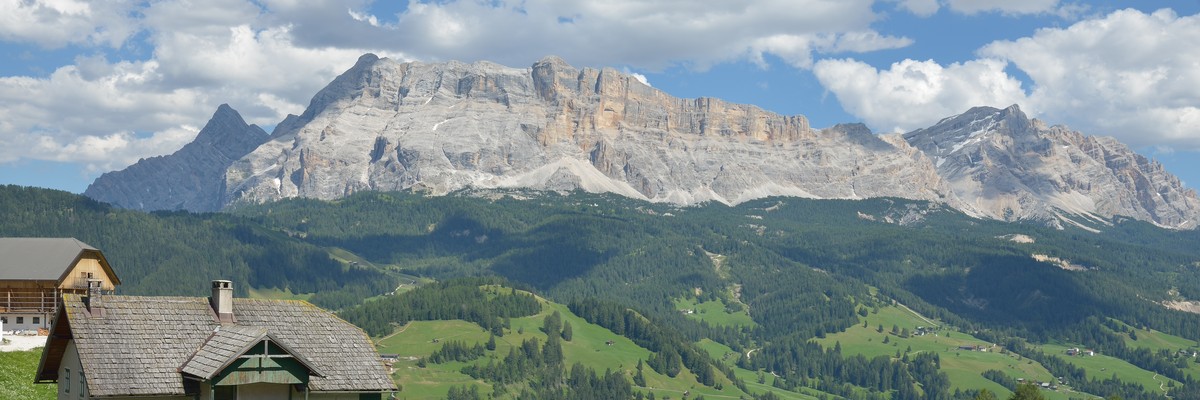
South Tyrol, or Alto Adige, is a province in northeast Italy. It includes part of the Dolomites range, with limestone summits like the Three Peaks of Lavaredo and many other major summits and cliffs.
description
South Tyrol is a highly mountainous region and thus also offers endless climbing possibilities.
You can choose between vast, warm valleys, full of apple trees, wine and even palm trees, where you might experience an almost Mediterranean feeling. On the other side, South Tyrol also has a wilder, more rugged, but equally impressive side: the impressive Dolomites, Alpine flora with some of the highest peaks in the Eastern Alps such as the Ortler. In between, there are high-Alpine pastures, deep valleys, earth pyramids, crystal clear lakes, roaring waterfalls and endless cliffs. Make your pick!
The climbing region on theCrag isn't completely identical with the Italian province as parts here are listed within the Dolomites region and Bormio area, too.
See and edit Dolomites here.
1.1. Val Pusteria 532 routes in Region
- Summary:
-
Mostly Sport climbing
Lat / Long: 46.994206, 12.082544
1.1.1. Zillertaler Alpen 282 routes in Region
- Summary:
-
Mostly Sport climbing
Lat / Long: 46.911648, 11.746954
description
1.1.2. Rieserferner 249 routes in Region
- Summary:
-
Sport climbing, Bouldering and other styles
Lat / Long: 46.870045, 12.074286
summary
The Rieserferner mountains extend across the Austrian state of Tyrol and the Italian province of South Tyrol (Trentino-South Tyrol region). The mountains mainly lie in South Tyrol, where the greater part is protected within the Rieserferner-Ahrn Nature Park.
description
AVE 37
Austrian part see: http://www.thecrag.com/climbing/austria/klagenfurt-area/area/790649025
1.1.3. Villgratner Berge 0 routes in Region
description
AVE 38
1.1.4. Venedigergruppe 0 routes in Region
description
AVE 36
1.1.5. Dreifingerspitze 1 route in Cliff
- Summary:
-
All Alpine climbing
Lat / Long: 46.709952, 11.990039
1.2. Höhlensteintal 363 routes in Area
- Summary:
-
All Sport climbing
Lat / Long: 46.670489, 12.245972
summary
Höhlensteintal (Val di Landro) is is a side valley of the Puster Valley in South Tyrol, Italy. It hosts several crags in breathtaking scenery.
approach
Enter the Landro valley from Dobbiaco (Toblach) and follow the river Rienz.
1.2.1. Landro 87 routes in Crag
- Summary:
-
Lat / Long: 46.625536, 12.224950
summary
Multiple sectors, short access and great rock make this one of the most popular crags in Val di Landro.
description
"Blue Cafe" is the first sector on the left followed by "Hägar" and Hexentanz (here split in 2).
approach
( 46.6253503, 12.2257387)
From Dobbiaco enter the Val di Landro until you arrive just before Lake Landro, park on the right shortly after Lake Landro. The crag is visible on the right.
46.6253503, 12.2257387)
From Dobbiaco enter the Val di Landro until you arrive just before Lake Landro, park on the right shortly after Lake Landro. The crag is visible on the right.
1.2.2. Geierwand 60 routes in Crag
- Summary:
-
Lat / Long: 46.630133, 12.227174
summary
This crag above Lake Landro is comprised of 3 cliffs, Geierwand, Stube and Balkonien.
description
Great climbing on great rock with great views  .
.
approach
Park on the left side after the lake (coming from Toblach, ( 46.630082, 12.228987). See individual sectors for details.
1.2.3. Dürrensee 36 routes in Crag
- Summary:
-
Lat / Long: 46.630155, 12.235855
summary
A nice West facing cliff, but due to the mountains on the other side of the valley the sun leaves the crag at about 5:30pm.
approach
From Toblach / Dobbiaco drive towards Venice - Val di Landro. Follow the road up a the valley for quite a while, until you arrive at the second restaurant at Lake Landro. Park on the left (on the lake shore). From the parking lot follow the small path that leads towards the crag at the lefthand side of the lake. Once you spot a wooden bridge on your right cross the river. If the river is low you might be able to walk along the waters edge. Continue on path number 6 and at the junction, take the path to your right that leads along the side of the lake. A cairn marks the start of the small path that leads uphill and lefti nto the forest and to the base of the crag.
1.2.4. Grotta di Landro 57 routes in Crag
- Summary:
-
Lat / Long: 46.621733, 12.230676
summary
Crag characterized by two large caves with routes in various difficulties incl. hard grades.
approach
Pass Lake Landro, after a few hundred meters leave the car on the parking lot to the right. Across the road beyond the bike path and the river, there is a path that leads into the woods. After about 200 meters, turn left onto a wider path until you reach path 6b. Proceed until you find a little cairn from which another path starts to the left. Shortly after, behind a large rock, a steep path leads up to the cliff.
1.2.5. Franchi 31 routes in Crag
- Summary:
-
Lat / Long: 46.640829, 12.230807
summary
A crag with loads of hard routes and link-ups that is also well protected from rain.
approach
Easy to reach from the parking area. Please dont forget to have a valid parking ticket.
1.2.6. Militärklettergarten 30 routes in Crag
- Summary:
-
Lat / Long: 46.643853, 12.229138
summary
A great crag for beginner and intermediate climbers, lots of well bolted lines.
description
Gut gesicherter Klettergarten, sowohl für Anfänger als auch Fortgeschrittene.
history
This crag was developed by the military.
1.2.7. Val Rienza 61 routes in Crag
- Summary:
-
Lat / Long: 46.632071, 12.269729
summary
A nice and popular crag with great views.
description
Sun until 4pm.
approach
Drive into the Höhlensteintal (Val di Landro) and park near the hotel Drei-Zinnen-Blick (you need to buy a ticket). Hike into the valley in direction of Drei Zinnen (Tre Cime) until you see the sign for the crag and go up left.
1.2.8. Rienzwand 1 route in Cliff
- Summary:
-
Lat / Long: 46.618994, 12.281392
1.3. Val d'Isarco 281 routes in Region
- Summary:
-
Mostly Sport climbing
Lat / Long: 46.844410, 11.437594
summary
The Valle Isarco connects the Stubai Alps with the Dolomites.
description
The valley of the Isarco (Eisack) river stretches from Brenner Pass southwards down to its confluence with the Adige near Bolzano. The upper valley north of Franzensfeste is also known as Wipptal.
1.3.1. Hohe Festung 57 routes in Crag
- Summary:
-
All Sport climbing
Lat / Long: 46.775605, 11.624288
description
Der Klettergarten neben der oberen Festung in Franzensfeste erfreut sich bereits seit Jahren großer Beliebtheit bei Anfängern und Familien. Die grüne Wiese und zahlreiche liebevoll errichtete Bänke und Tische machen das Plätzchen am Wandfuß besonders gemütlich. Neu ist auch ein Übungsklettersteig für die ersten Meter in der Vertikalen.
The Klettergarten next to the upper fortress in Franzensfeste has been very popular with beginners and families for years, but advanced cimbers will also find interesting routes here, up to 6c+.
The area below the main wall is great too - green meadow with lots of benches and tables, plus anchors for slacklining.
The main wall Hauptwand is definitely the most popular; there are a few new routes that aren't described yet. The upper wall Obere Wand has lots of potential for further development, but for now you'll only find easy routes to the left and hard project routes in the overhang on the right.
approach
Park under the highway
1.3.2. Stohlwond 73 routes in Crag
- Summary:
-
All Sport climbing
Lat / Long: 46.870264, 11.261639
summary
Multiple sectors in a beautiful environment. Routes in many different grades, from beginners to hard movers.
approach
Drive in direction of Ratschings and park after the bridge after the ski resort. Follow the forest road down river and hike up left on a marked trail.
1.3.3. Mauls 18 routes in Cliff
- Summary:
-
All Sport climbing
Lat / Long: 46.828546, 11.532249
description
A relatively new crag with potential for more routes.
approach
Drive to Grasstein and park just before the village. Follow the bicycle path north, pass the power station and cross the bridge. You see the cliff below you on the left.
1.3.4. Ridnaun 25 routes in Crag
- Summary:
-
All Sport climbing
Lat / Long: 46.930696, 11.279101
summary
A sunny crag with rather short routes.
approach
Park near the mining museum in Ridnaun.
1.3.5. Waldkofel Spiluck 42 routes in Crag
- Summary:
-
Sport climbing and Bouldering
Lat / Long: 46.760779, 11.593770
summary
A relatively new crag with an amazing view of the Dolomites.
1.3.6. Mahr 65 routes in Crag
- Summary:
-
All Sport climbing
Lat / Long: 46.696347, 11.640310
summary
One of the older crags near Brixen.
1.3.7. Jaufenspitze Cima Giovo 1 route in Area
- Summary:
-
All Trad climbing
1.4. Zona Merano e Val Venosta 882 routes in Region
- Summary:
-
Sport climbing, Bouldering and other styles
Lat / Long: 46.699422, 10.833709
1.4.1. Tisner Auen 48 routes in Crag
- Summary:
-
All Sport climbing
Lat / Long: 46.572108, 11.181091
summary
A roadside, East-facing, porphyr crag found at the end of the apple fields of Gargazzone/Gargazon. Fairly recent crag, lots of high-quality trail building, nice fresh bolts and well cleaned rock.
description
Sector A has beginner friendly/warmup routes Sector B has lovely climbing from 5b - 8a
Popular routes are fresh and frictiony, bring a wire brush for the less popular routes.
access issues
None
approach
Two distinct sectors (A & B): A is accessed directly from the carpark B is the upper sector, accessed by climbing "Was guckst Du???" (4b+)
If you trip over getting out of your car you might be able to belay the first climbs
From the MeBo, take the Gargazzone exit, head SW through apple fields for approx. 2kms straight. There is a carpark, toilet and information panel where the road veers left - park here.
where to stay
Carpark
ethic
Bolted cracks, slabs
history
Only recently developed with help from Alpenverein Sudtirol!
1.4.2. St. Hippolyt 35 routes in Crag
- Summary:
-
All Sport climbing
Lat / Long: 46.580879, 11.159593
summary
Easier to intermediate routes on a vertical cliff, a small roof for the more ambitious climbers as well.
description
In a wooden box in the center of the crag there is a topo as well as some brushes. Please take care and return these items. Some routes have their names written onto white rocks at the base / (close to) their starts. There is a bench and other seating options in close proximity. Recently the closest trees have been cut down allowing for more direct sun light, still some shade is provided by the farther trees and hills surrounding the area.
approach
Park at Parkplatz Wanderweg Kirche St. Hippolyt (46.576374, 11.163244)
There should be signs leading to the crag starting at the parking lot. Otherwise: Follow Sentiero 7 (left from carpark), cross the stream, turn right and follow the trail to lake Hippolyt Weiner. Cross the stream at the start of the lake, go uphill approx. 100 m to the base of the crag (46.580856, 11.159885).
All routes can be seen from main area.
1.4.3. Fragsburg 27 routes in Crag
- Summary:
-
All Sport climbing
Lat / Long: 46.643042, 11.196381
summary
One of the older crags near Meran with little traffic. Thus some of the routes might be dusty or overgrown. Still a great crag for beginners and intermediate climbers.
1.4.4. New Fragsburg 31 routes in Crag
- Summary:
-
All Sport climbing
Lat / Long: 46.638117, 11.202231
summary
One of the better crags near Meran with many harder routes. Can even be climbed in winter on sunny days.
approach
From Merano to Scena, at Rametz turn to Castel Fragsburg, remain on this road until you pass Fragsburg, proceed for 100 metres and park at the waterfall.
On the left take the path leading to the Fragsburg climbing garden, past the rock blocks. The routes can be approached via the iron ladder.
1.4.5. Algund 141 routes in Field
- Summary:
-
All Bouldering
Lat / Long: 46.691023, 11.110801
summary
One of the most popular bouldering areas in South Tyrol.
approach
Make your way to Algund and park depending on which areas you want to go to. Also accessible by public transport.
1.4.6. Wasserfall 1 route in Cliff
- Summary:
-
All Sport climbing
description
Arrampicata a lato della cascata
approach
Da Merano in direzione Val Venosta fino a Parcines, dal centro direzione cascata
Parcheggio Parcheggio pubblico (gratuito) presso il ristorante Birkenwald
Trasporto pubblico Con autobus da Parcines linea 265 - fermata Wasserfall
1.4.7. Burgstollknott 39 routes in Crag
- Summary:
-
All Sport climbing
Lat / Long: 46.688442, 11.073982
description
Beim Burgstollknott handelt es sich um einen kleinen, familien- und anfängerfreundlichen Klettergarten. Da der Wandfuß recht abschüssig ist, wurde hier eigens für Familien ein angenehmer Platz mit Bänken und Tischen erbaut. Geklettert wird auf kompakten Gneis, der von Platten bis hin zum leichten Überhang alle Steilheiten aufweist. Es sind Sitzmöglichkeiten sowie eine Lagerfeuerstelle vorhanden. Weiter eine Tafel mit Topo sowie Code für Vertical-Life.
approach
Nach Partschins. Im Ort kostenfreies Parken in der Zehenstraße (46.68575833, 11.07560608) oder beim Schwimmbad (46.68492554, 11.078500139).
Von dort die Zehenstraße Richtung Westen, rechts in die Römerstraße hinauf. Nach 230 Metern gibt es eine Beschilderung Klettergarten. Dieser folgen.
1.4.8. Hochgang 0 routes in Field
description
A high altitude bouldering area (above 2000m ASL) near the Hochganghaus.
1.4.9. Gingglegg 1 route in Cliff
- Summary:
-
All Rock climbing
Lat / Long: 46.706945, 11.033200
approach
Con la funivia Texel si arriva direttamente all'imbocco della famosa Alta Via di Merano (n. 24). Da lì, ci si incammina verso ovest in direzione del rifugio Nasereit e dopo circa un'ora si raggiunge la parete
1.4.10. Huafwond 38 routes in Crag
- Summary:
-
All Sport climbing
Lat / Long: 46.684973, 11.049382
description
Die eindrucksvolle Felspyramide der Huafwond liegt in einem steilen Hang direkt oberhalb Partschins und sticht bereits von weitem heraus.Wer diesen Klettergarten besucht,dem wird eine atemberaubende Aussicht auf den Meraner Talkessel geboten. In mühevoller Arbeit wurden riesige Podeste und Bänke errichtet, um den Wandfuß gemütlicher zu machen.
approach
a)Bequem über die Texelbahn zur Bergstation und von dort in 7 min zur Wandfuss, auf dem Weg zum Dursterhof zweigt nach ca. 5 min ein Steig (Metallschild vorhanden) nach rechts (Westen) ab.
b) Mit dem Auto zum Dursterhof, von dort aus dem Wanderweg Richtung Texelbahn ca. 45 min zum Wandfuss folgen. Anschliessend den Steig (Metallschild vorhanden)in 3 min. zur Kletterwand folgen.
1.4.11. Wintertraum 28 routes in Crag
- Summary:
-
All Sport climbing
Lat / Long: 46.652753, 10.986711
summary
A very sunny crag with climbing on edges, cracks and slopers. Great for cold days, even winter.
approach
Drive to the centre of Naturns and from there in direction of Sonnenberg until you see a bigger parking on your right (46.65825, 11.00817). From there follow the Wallburgweg for about 30 minutes until you find a trail up to the right.
1.4.12. Schnalstal 161 routes in Region
- Summary:
-
All Sport climbing
Lat / Long: 46.710159, 10.878833
summary
The Schnalstal (Val Senales) is a side valley of the Vinschgau in the autonomous province of South Tyrol, Italy.
1.4.13. Latsch 74 routes in Crag
- Summary:
-
Mostly Sport climbing
Lat / Long: 46.622859, 10.853232
- The very beginner-friendly sector Alpingeschichte
- The more demanding sector Latsch Vegas which is a little further to the left.
- The multipitch sector Alpin, in the middle of the cliff
summary
Einer der populärsten Klettergärten im Vinschgau.
One of the most popular climbing areas in the Vinschgau.
description
Der Klettergarten wird in zwei Sektoren unterteilt. Der sehr anfängerfreundliche Sektor Alpingeschichte und der anspruchsvollere Sektor Latsch Vegas der etwas weiter links liegt.
This crag is divided into three sectors:
approach
Mit dem Auto von der SS38 am Kreisverkehr nach Latsch abbiegen und den gratis Parkplatz auf der linken Seite verwenden (gegenüber der Seilbahn). Mit dem Bus die Haltestelle Latsch Seilbahn St. Martin. Von dort zu Fuss zurück Richtung Kreisverkehr und den Wanderschildern (Waalweg) direkt leicht bergauf folgen. Erste Abzweigung links nehmen und dem Waalweg eine Weile (ca. 600m) folgen. An der Stelle mit einer Brücke aus kleinen Holzbrettern über den Waal (kleiner Bach) nach rechts steil hinauf abbiegen (GPS 46,6231292, 10,8623393). Dann ca. 200m Weile auf dem Steindamm entlang und dann den Hang hoch. Dem Weg weiter folgen, 200m zwischen den Steinschlagauffängern aus Stahl hindurch direkt zum Klettergarten. GPS Daten: (46.623056, 10.856667)
By car from the SS38, turn off at the roundabout to Latsch and use the free car park on the left (opposite the cable car). By bus, take the bus stop Latsch Seilbahn St. Martin. From there walk back towards the roundabout and follow the hiking signs (Waalweg) directly slightly uphill. Take the first turning on the left and follow the Waalweg for a while (approx. 600m). At the point with a bridge made of small wooden planks over the Waal (small stream), turn steeply uphill to the right (GPS 46.6231292, 10.8623393). Then walk along the stone embankment for a while (200m) and then up the slope. Continue along the path, passing between the steel rockfall barriers directly to the climbing garden. GPS data: (46.623056, 10.856667)
For Alpin, take the Waalweg in the same direction. After ~300m you reach a gate. Turn left up this trail and continue through the forest to the base of the cliff.
For Latsch Vegas, directions unknown please clarify
1.4.14. Schlanders 21 routes in Crag
- Summary:
-
Mostly Sport climbing
Lat / Long: 46.632570, 10.779668
1.4.15. Allitz 23 routes in Crag
- Summary:
-
All Sport climbing
Lat / Long: 46.631841, 10.714133
description
Kids friendly crag with short approach and perfect infrastructure. The crag has a large, flat base and features a table and benches. Route names are labelled at the base of the crag. The routes are short and very well protected, but partially very close to each other.
approach
Coming from the Vinschgau valley on the Strada Provinicale 109, direction Laas, there is a parking lot on the left hand side directly before crossing the bridge to Allitz. From there, signs show the way to "Klettergarten": Follow the gravel road for about 200 m until you find a footpath on the right hand side. This leads to the crag after a few meters.
where to stay
There is a nice campground and various accommodations in Laas.
1.4.16. Nesselwand - Laas 51 routes in Crag
- Summary:
-
All Sport climbing
Lat / Long: 46.586264, 10.700568
summary
A unique experience to climb on marble make you forget the long hike!
1.4.17. Laaser Tal 4 routes in Area
- Summary:
-
All Ice climbing
Lat / Long: 46.572488, 10.687021
1.4.18. Martelltal 116 routes in Crag
- Summary:
-
Sport climbing, Rock climbing and Trad climbing
Lat / Long: 46.538919, 10.760445
summary
Martell is a southern side valley of the Etschtal in South Tyrol. It offers several climbing crags and a huge artificial wall on the dam of Zufrittstausee.
approach
Enter the Martell from Latsch.
1.4.19. Fuchsknott 17 routes in Cliff
- Summary:
-
All Sport climbing
Lat / Long: 46.516346, 10.580278
description
A small crag for hot days.
1.4.20. Bärenfels 17 routes in Cliff
- Summary:
-
All Sport climbing
Lat / Long: 46.511992, 10.602352
description
A older crag initially equipped by the army. Great for summer an warm days.
1.4.21. Ortler 9 routes in Area
- Summary:
-
Alpine climbing, Ice climbing and Rock climbing
Lat / Long: 46.511136, 10.545961
summary
Ortler is, at 3,905 m (12,812 ft) above sea level, the highest mountain in the Eastern Alps outside the Bernina Range. It is the highest point of the Southern Limestone Alps, of South Tyrol in Italy.
1.5. Zona Bolzano e Bassa atesina 693 routes in Region
- Summary:
-
Mostly Sport climbing
Lat / Long: 46.527440, 11.350841
summary
As a major regional city, Bolzano/Bozen has an extraordinary variety of climbing on different rock types within a 30-45 minute drive of the centre of town.
1.5.1. Sarner Scharte 10 routes in Area
- Summary:
-
Mostly Trad climbing
Lat / Long: 46.650019, 11.407541
- West face (the first climbed area, longest classic routes)
- South west face (the 2nd area to be developed, characterised by very low angle friction slabs)
- North west buttress (the smaller towers to north, more recently developed in a "trad" style, more modern style crack climbing)
summary
Sarner Scharte is a large porphyr wall, approximately 400 metres in height, found in Sarntal/Val Sarentino, the valley north of Bolzano/Bozen.
description
The climbing is divided into 3 distinct areas:
access issues
Fatigue; there's a big fat uphill to slow you down.
Coming from Bolzano, just before Sarentino/Sarthein, turn right up towards Riedlsberg/Montenovale.
Follow this road for approx 6kms until Riedlhof. Park here, or 300m ahead at another carpark.
approach
1 - 1.5 hour approach!
From Riedlhof, follow the trail 3 to Sarner Scharte/Forcella Sarentina.
Stay on this trail for ~2kms, until you reach a point where trail 3 veers right, and to your left there's a field with a fence. Turn left, crossing the field until your enter into the forest (following trail 3B).
After ~600m, you reach a cross and an intersection. Turn right (towards the biiiig cliff), following trail 3A.
Follow this trail until you reach a climbing guide/map. From here you can access individual routes.
ethic
"Alpine climbing" ethic
Routes have been bolted only where natural protection is not available.
Almost all climbs require some natural gear, with the rock providing many nice cracks, corners, nooks and crannies to jam your flashy bits into.
Many of these routes (especially the easier grades) use natural/trad anchors! Make sure you know how to build safe trad anchors before questing up the Scharte.
history
Climbing has been happening on Sarner Scharte since the late 1970's, with the likes of Heini Holzer, Heinz Steinkötter and Hans Pescoller.
1.5.2. Johanneskofel 68 routes in Cliff
- Summary:
-
Mostly Sport climbing
Lat / Long: 46.548073, 11.368819
description
One of the oldest developed crags near Bolzano. Located at the base of Johanneskofel near a small creek.
approach
Drive into the Sarntal and pass the palace of Runkelstein. Park in front of the 3rd tunnel. Follow the path downhill to the creek and continue down on the road along the creek. Pass a tunnel, just after that is the first sector.
1.5.3. Tanzbach 13 routes in Crag
- Summary:
-
All Sport climbing
Lat / Long: 46.598896, 11.380447
summary
A small tower next to a creek. Popular with locals.
1.5.4. Windlahn 15 routes in Cliff
- Summary:
-
All Sport climbing
Lat / Long: 46.608793, 11.388290
description
A small crag just next to the road.
1.5.5. Mittelberg Grindlegg 26 routes in Crag
- Summary:
-
Sport climbing, Rock climbing and Trad climbing
Lat / Long: 46.572096, 11.488471
1.5.6. Margarethenbach Wasserfall 1 route in Crag
- Summary:
-
All Sport climbing
Lat / Long: 46.521916, 11.268430
1.5.7. Unterinn 47 routes in Crag
- Summary:
-
Mostly Sport climbing
Lat / Long: 46.508795, 11.419076
summary
A lovely SW Bolzano porphyry crag. Mostly sport climbs.
description
There about 50 routes on very compact "Bolzano porphyr". It is southwest facing, making it ideal for cooler days, morning/evening in summer or sunny winter days.
approach
From Bolzano head towards Cornedo (Karneid) and then towards the Renon. Climb the road towards the village of Unterinn. Before arriving in the town, turn left onto the Via dei Romani and park near the church (46.5077, 11.4324)
Walk up the road for about 200m, then take the first left (in front of house NR 23). Follow this for another 200m and go up a steep sealed private road. You pass a house and a little field, and when this path ends turn left. Follow this path to the crag.
history
Work started on the Unterinn crag in 2010, but it became official only in 2015.
1.5.8. Jenesien 61 routes in Area
- Summary:
-
Mostly Sport climbing
Lat / Long: 46.514766, 11.316569
1.5.9. Bagni Di Zolfo 22 routes in Crag
- Summary:
-
All Sport climbing
Lat / Long: 46.504898, 11.295805
summary
Area di arrampicata in porfido alle spalle dell'ospedale di Bolzano. Contiene diversi settori e alcune vie di arrampicata più facili.
approach
A Bolzano, seguire via Druso in direzione dell'ospedale, alla rotonda immettersi su via Merano, proseguire superando il distributore e l'incrocio con via S. Maurizio, subito dopo c'è un parcheggio sulla destra, da qua costeggiare la strada e svoltare per via S. Maurizio, subito dopo c'è una carrozzeria e a sinistra, l'ingresso alla falesia.
where to stay
Downtown b-town
ethic
Maggioranza arrampicata sportiva, alcuni vie in fessure attrezzate
1.5.10. Piccola Virgolo 9 routes in Crag
- Summary:
-
All Sport climbing
Lat / Long: 46.489175, 11.351539
Park at Chiesa del Calvario al Virgolo / Santo Sepolcro
Walk for 5 minutes along sentiero Nr. 4 (marked red/white stripes) until you reach the crag
summary
Small crag, easy to reach, with most routes in the 5a-5c range. It is on the side of a walking trail and has a bench right there.
description
A small slab of high quality porphyr. Well-bolted with glue-in ringbolts, very accessible anchors (some of the rappel carabiners look a bit old).
Seems to be fairly ignored/forgotten - but it is a great beginner's climbing area close to to Oltrisarco/Aslago.
This slab is completely developed in terms of climbing. There are some other sections of rock around for future development? The quality looks worse though.
approach
history
Unknown?
1.5.11. Virgolo Cracks 6 routes in Crag
- Summary:
-
All Trad climbing
Lat / Long: 46.484479, 11.359222
Park at the abandoned hotel (46.490444, 11.356353)
Follow Nr.10 for approx. 1km until you reach a T-intersection with a picnic bench.
Turn left up to the boulders.
Access from hiking trail Nr.3 in Oltrisarco/Aslago (46.483980, 11.351812)
Follow Nr.3 up to the Forestry Road, turn left. After ~20m, follow the red/white hiking trail the divides to the right (slightly uphill) of the forestry road.
Follow this trail for ~1km until you reach the Nr.10 trail.
Turn right, follow for 1km until you reach the picnic bench at the T-intersection, turn left up to the boulders.
Bottom access (~15-20mins) (more difficult navigtion, requires rope ascending equipment):
From the boulders, follow the main hiking trail uphill. It turns sharply left almost immediately, then after ~300m sharply to the right. After approx. 300m, a small man-made rock wall forms on the right. There is an obvious cairn on the left.
Veer left off the trail, going uphill diagonally to the right at the base of small chossy wall/cliff. Continue going diagonally uphill until you reach the base of sheer cliff.
Put on your harness. At this point, stay close to the cliff, continuing uphill past some old construction material & a bucket (~200m).
When you reach high tree looped with some climbing rope, crack out the ascenders. Climb the rope (past 3 bolts) until you reach the crag).
Top access (15mins):
From the rock-wall/cairn, keep following the hiking trail uphill. It turns sharply left after ~1km.
Continue uphill ~1km until GPS (46.484075, 11.359616).
Start traversing to the right (gently downhill) until you reach the cliffs.
Various trees can be used as abseil anchors to access the top anchors of climbs (always use caution & judgement, equalise two trees if you're not sure)
summary
A brilliant new crack climbing crag in the cliffs above the suburb of Oltrisarco-Aslago.
description
Routes described from L-R (looking at the cliff)
approach
(Windy Maps recommended - shows all the hiking trails)
2 different parking spots:
From the boulders (46.484137, 11.356704), you have two options to access the cliff:
Extremely detailed approach here (in italian)
ethic
Trad climbing. Do not, under any conditions, bolt a climb that can potentially be climbed used natural protection.
Take your filthy semi-automatic bolt cannons elsewhere...
history
Developed in 2020/2021 Thanks to Michele Caminati!
1.5.12. Regno dei Ragni 19 routes in Crag
- Summary:
-
All Sport climbing
Lat / Long: 46.484717, 11.355309
summary
A moderately developed climbing area found just behind Aslago/Haslach. Approx. ~20 pleasant short sport climbing routes on classic Bolzano porphyr.
description
Despite its fairly large size and proximity, this crag has been more or less ignored for a great deal of time.
Come for the climbing, stay for the zen garden! Explore Lino's magnificent water-catchment system off the rocks, rest on one of the hand-made benches or admire the beautiful tiered gardens.
access issues
None
approach
recommended approach by bicycle
By car: try and find parking somewhere in the street nearby
Starting at (46.484044, 11.351679), follow Sentiero #3 approx. 500m until you reach a large, obvious forestry road.
Turn right and walk approx 100m. On the left there is a tree with a wooden sign "falesia/klettergarten", where the trail turns sharply left. Follow the trail, at the next intersection veer left. The trail crosses the scree/boulder field and back into the woods. Continue up the trail, you will see a boulder painted with "Regno dei Ragni" and an lycra-clad 80's sport climber. You have arrived.
where to stay
Bolzano/Bozen?
ethic
The established climbs are bolted sport climbs.
Definitely potential for trad/mixed lines. Do not place bolts where natural protection can be used!
history
Try and find the wonderful Lino Marasca hanging on a rope somewhere nearby - he has been climbing here since 1954. Say hi! You'll be rewarded with some amazing stories.
2007/2008 - Fabio Bissardella bolted & rebolted the majority of the lines seen today.
1.5.13. Seitner Berg 114 routes in Area
- Summary:
-
Mostly Sport climbing
Lat / Long: 46.466770, 11.346498
summary
"Seit Mountain" the large plug of Bolzano porphyr, above Bolzano & San Giacomo
Home to the crag of San Giacomo, plus sport & trad multipitches above Castle Flavon/Pareti del Sait
1.5.14. The Giant's Head 2 routes in Crag
- Summary:
-
All Trad climbing
Lat / Long: 46.445332, 11.356496
Take the road from Pineta/Steinm. in direction of La Costa/Seit.
Park at (46.445772, 11.354566) Have a look at the crag from the hunter's lookout - down to the right.
From the sharp corner, turn L taking the small semi-obvious trail going uphill. Follow the trail uphill (it zig-zags a little, try and stick to the main trail and keep marking it out). You pass an old wire fence and a small clearing on the left. Start veering lightly to the right, up a steeper slippery slope (30m) to a flat section, an old mountain road/hunter's trail (46.445784, 11.355571) (about 200m in total).
Lower access: From here, follow the trail downhill to the right. Go over a section of fallen trees, looking out for the cairns (stone piles). From the trees, go straight, traversing the slope for approx. 100m to the base of the cliff (46.445251, 11.356365).
Top access: From the road/trail (46.445784, 11.355571), continue uphill, tending slightly to the right (towards the crag), for approx. 100-150m until you reach another flat section, with a single-track hunter's trail (46.445802, 11.356000). Turn right on the trail, turning towards the crag. Follow the trail, through thicker vegetation (the trail becomes very obvious), up a small rock-step (standing on an old tree stump), gently uphill, then finally a rocky down-step (watch out for the spiky bushes). Walk along the back edge of the cliff (staying close to the forest), then approach the main edge of the cliff from the easternmost side. There is some old rope on a reliable abseil tree at the top of the cliff (46.445325, 11.356526).
Abseil on a 60m (plus extension to the edge of the cliff, rope protector recommended). Secondary abseil at 30m possible off
summary
The legend says, in the deep, shady valley above Steinmannwald, there lies an old giant who protects the forest and the animals from the evils of humanity. We just see his head, and there we climb!
description
A brand-spanking new crag above Pineta/Steinmannwald. Got some mighty potential for a bit of everything - roofs, cracks, slabs, aretes.
access issues
The road from Pineta - La Costa is * officially * closed but driveable. Go at your own risk etc ...
approach
Driving:
ethic
TRAD ONLY
NO BOLTS
This rock has amazing potential for naturally protected lines. Do not destroy this potential with bolts!
If a new climb needs a bolt(s) in order to not be a death route, contact (tgbuckley) or any of the other new-school developers around Bolzano (Red Rocks guidebook developers or M. Camminati)
history
Exploration around this cliff started in summer 2021, followed by the first lines going up in the following autumn.
1.5.15. Rio Vallarsa 0 routes in Crag
summary
The big, beautiful crumbly walls above the Rio Vallarsa
description
A huge area of cliffline ranging from single pitch to rambling multis.
Lots of potential for development (between the choss)
access issues
Unknown
approach
Cross the Rio Vallarsa above Casa Emmaus
ethic
sconosciuto
history
sconosciuto
1.5.16. Monte Macaion 2 routes in Area
- Summary:
-
Trad climbing and Sport climbing
Lat / Long: 46.493860, 11.210568
summary
Macaion/Gantkofel is known for being the extraordinary prominent face looking down on Bolzano from the SW. It is most obvious on the drive to Meran(o)
description
Some alpine-style routes are present on the large faces. Rock quality is average
1.5.17. Col dell'uomo 30 routes in Crag
- Summary:
-
Mostly Sport climbing
Lat / Long: 46.446793, 11.299687
- 1.
- Park at Sportzone "Rungg" / Zona Sportiva "Rungg".
- 2.
- BICYCLE APPROACH from Bolzano etc (approx. 35-40 mins walk)
summary
Another great porphyr crag, found in the centre of the Monticolo/Montiggl forest.
description
Originally developed by the Club Alpino Italian & Alpenverein Sudtirol, this is a lovely beginner/intermediate crag found in the middle of the forest near Monticolo/Montiggl lake.
The rock is Bolzano porphyr of varying quality, all routes are 20m or less (you're ok with a 40m rope).
Lots of good quality beginner/intermediate routes, with a couple of advanced climbs too. Nothing above 7b, so the crushers should look elsewhere.
Toprope access for almost all the climbs; a via ferrata goes along the top of the cliff, with bolts that you can use to abseil to the top-anchor of the climbs.
approach
Take the "Rungg" Forestry road to the right of the sports field. Stay on this road until you reach a barrier.
From the barrier, follow a wide trail for approx. 20 minutes to the crag. (marked "Palestra di roccia)
On the Valle dell'Adige cycle path, leave your bike on the corner after the bridge at GPS (46.447492, 11.307097).
Looking towards the farmer's field, go left up and around the gate (there is an ok-ish trail).
Follow this trail uphill, turning left almost immediately. Pay attention to cairns (piles of rocks indicating the trail), due to landslides the trail changes directions multiple times.
Eventually you'll reach an old road that continues traversing up the hill. You are aiming for GPS (46.452097, 11.299512) on top of the hill.
When you reach the trail junction at the top of the hill turn left (south) and walk 5-10 minutes to the crag (indicated with signs).
history
Many thanks to the Alpenverein & Club Italiano Alpino of Appiano.
1.5.18. Montiggl crack 1 route in Area
- Summary:
-
All Trad climbing
Lat / Long: 46.447395, 11.302943
description
Hidden wall closed to col dell'uomo with view on the rivers Eisack, Etsch and the south part of Bozen. Until now only one completely clean route set. There is some potential for bolting a Sportclimbing sector. But please be Respectful with landowners and wildlife. Owls nesting on the lower part of the wall, please do not abseil there, contact Sempervivum for more info.
approach
Same access as col dell' uomo crag until you reach the meaddow with electricity lines. Follow the path parallel to the electricity lines, after a short uphill section there is a yellow/ black marking and a trail starting at the left side. Folow for +- 50 m and you can see the wall at your left. Now you have 2 possibilities: follow the wall to get to the bottom of the route, or follow the path to get to the top to build an anchor for some inspection or toprope.
ethic
Quite area with not too much humans, please be respectfull. Potential for Sportclimbing but have to be checked with officials, Owl nesting has benn seen in one part of the wall.
1.5.19. Skinwalker 4 routes in Crag
- Summary:
-
All Trad climbing
Lat / Long: 46.434565, 11.243586
summary
The final porphyr above Appiano/Eppan before arriving at Passo della Mendola.
approach
Park the car in one of the two laybys on the main road and enter by foot in the area closed by the bar. Go uphill to the right and then down after the hunting hut. Leave the path and diagonally cross the rocky zone upwards, until you reach a vague trail on the top-right of it (cairns). Follow the trail up towards the cliff and then back left. Go all the way up and left and pass an exposed section (rope in place). From here you can go up to "Skinwalker" or left to "Toewalker" .
1.5.20. Pfattner Wände 6 routes in Crag
- Summary:
-
All Trad climbing
Lat / Long: 46.403287, 11.292427
(46.42267, 11.28172), Drive through the roundabout down to the lake. On the big L-hand corner, before Hotel Moser and the paid carpark, turn right down a small road. After about 200m, there is a small carpark on the side of the road (4 spots)
(46.424675, 11.282478) You will notice leading to the lake that many people park on the side of the road - if it is a busy day this might be your best free option.
Use the paid parking at the roundabout (46.422970, 11.28186) OR drive down to the lake (46.421860, 11.286033) (you save 10mins walking, often full)
summary
The stupendous cliffs above Pfattner/Vadena, composed of the obvious columns of Bozen/Bolzano porphyr.
description
Almost the entirety of the cliffs is undeveloped - in the last 7/8 years a handful of routes have gone up on/around a column of high-quality rock in the middle of the cliff.
access issues
Warning do not let rocks fall into the forest/fields below the cliff. There have been problems with the farmers who live below, and the police.
approach
Set the GPS for Lago di Monticolo / Montigglsee.
Follow the signs for Monticolo.
Parking options:
From here, continue on foot along the forestry road through the woods. Follow it all the way until you reach the RAI Radio Station & antennae.
50m before the building, a trail branches off to the right, which you follow until you see the drop-off on the left. At the next gentle curve to the right, you leave the trail to find the top anchors of various climbs.
ethic
Big crack systems on solid rock. A lifetime of high-quality trad lines available on the cliff. Please do not put bolts where climbs can be protected with trad gear!
history
Earliest development in 2009 by the Riegler brothers' Cojote.
1.5.21. Trodena Molini 70 routes in Crag
- Summary:
-
All Sport climbing
Lat / Long: 46.313174, 11.322620
description
The wall diagram is located in place in a notice board hanging on the rock.
There is a third sector of which there is no report. It is characterized by more demanding routes than the other 2 and can be traced thanks to a sign placed on one of the hairpin bends above the hotel (therefore continuing the road by car).
approach
"Zur Muhle" (at the mill) recognizable by the water mill wheels and the wooden gutter suspended above the road. There it is possible to park. Take the road towards the valley, on the right side you will immediately find a sign indicating the gym. 5-10 minutes of trail.
Parking space of "Zur Mühle". Park as far down as possible.
1.5.22. Fennberg 41 routes in Crag
- Summary:
-
Mostly Sport climbing
Lat / Long: 46.288976, 11.177193
1.5.23. Graun - Hintersegg 22 routes in Crag
- Summary:
-
All Sport climbing
Lat / Long: 46.320106, 11.213352
approach
1.5.24. Garbe 18 routes in Cliff
- Summary:
-
All Sport climbing
Lat / Long: 46.251866, 11.239725
description
A small crag also nice on hot days.
1.5.25. Cortaccia - Kurtatsch / Kreidlwaende 8 routes in Cliff
- Summary:
-
All Rock climbing
Lat / Long: 46.316948, 11.200281
1.5.26. Bletterbachtal 1 route in Area
- Summary:
-
All Ice climbing
Lat / Long: 46.356536, 11.395970
1.5.27. Morderplotta 45 routes in Crag
- Summary:
-
All Sport climbing
Lat / Long: 46.317182, 11.211617
- Dolomite or Limestone?
- Please help
summary
A very sunny crag with good rock quality.
description
A high concentration of 6's & 7's means Mother Nature, akak the God of Rock, aka Bon Jovi, has provided us all with a TRAINING GROUND.
Get out here, slap on some tight lycra and GET SWEATING.
An abundance of fingery, crimpy, technical climbing awaits the FUTURE SEND.
approach
In the car, drive to Cortaccia, then navigate your way to (46.315215, 11.210238). Find a spot on the corner somewhere.
From the car, walk ~100m back towards Cortaccia. Turn left up the small, steep road (marked "solo per abitanti"). Follow the road and around to the right, past some gravel parking spaces, then up and left around the sharp bend.
Continue straight where the "Alter Grauenweg" goes right. Another ~200m, then on the sharp R corner, a hiking divides to the L.
Follow this ~20m to the crag.
where to stay
Sleep in you car in the carpark? Fucked if I know
ethic
Bolts, sport climbing.
Bring a brush! Some climbs are veeeeeeeeeeeery smoogey and slippery
history
??
1.5.28. Roter Kamin / Camino Rosso 2 routes in Area
- Summary:
-
All Sport climbing
Lat / Long: 46.376223, 11.330182
summary
Parking the Car at the Aldeiner Hof in Burgstall ( Montan,Ora ) Take the Hiking Trail in the direction of Rotwand from the platform of the rotwand you go on the path towards the small lake. after 50m go down to the left into the wood for 40m and follow the rocky strip up to the top of the pillar.to get to the base you have to rappel down three times. each belay chain with ring
description
Roter Kamin / Camino Rosso
approach
dalla piattaforma della rotwand si va avanti il sentiero verso laghetto. dopo 50m si scende verso sinistra nel bosco per 40m e si segue la fascia rocciosa fino il top del pilastro. per arrivare alla base obbligatorio tre calate. ogni sosta catena con anello. obbligatorio 6a
history
stupendo camino di 60m roccia ottima
1.5.29. Unterrain 1 route in Area
- Summary:
-
All Trad climbing
Lat / Long: 46.497561, 11.245888
approach
Park your car at Unterrain / Riva di sotto and follow the road trough the apple fields leading to the wall.
ethic
Clean crack climb witch bolted belays. !! Be aware of the road passing under the wall, used by bikers, hikers and farmers!!
1.5.30. Matschatsch 6 routes in Crag
- Summary:
-
All Trad climbing
Lat / Long: 46.443771, 11.241742
summary
Quality single Pitch crack climbs on eccelent Rock with acces from above trough abseiling on trees or Bolts. Potential for new crack climbs, please contact autor for informations.
approach
Park in the parking lot near Castel Matschatsch, take the forest road to the big meadow, follow it to reach the opposing corner of it to reach a small humid area and the rock edge, on your right you can already see the "Fingerspitzengefühl“ sector. Look for a small trail following the cliffs edge leading to an old highline anchor with 3 bolts. Follow the path close to the cliff edge witch leads to a little canyon on the left. For "Doppelmoral" descent the canyon for 30 meters and you will see the corner with bolted beay at your left. For the other Routes dont descent the canyon but cross it to get on the cliff edge again. Shortly after there will be "Corstisol management" and "Three little birds" on your left and if you continue the path there are the last 2 routes on your left. If you reach the second iron hearth you are too far, go back a bit and check the cliff edge
ethic
Trad climbing area, we would like to keep bolts only on belays where natural protection is not possible,
sensitive area
history
Discovered in November 2020
1.5.31. Etsch Flussboulder 18 routes in Field
- Summary:
-
All Bouldering
description
Größtenteils kleine Boulder mit max. Höhe 2 Meter.
1.5.32. Sektor "Pain" 7 routes in Boulder
- Summary:
-
All Bouldering
Lat / Long: 46.489449, 11.349755
description
4,5 Meter high Bloc near sector "Piccola Virgolo"
approach
Near the road around 50 lower than "Piccola Virgolo"
1.5.33. Big Block 1 route in Area
- Summary:
-
All Bouldering
Lat / Long: 46.492254, 11.355194
summary
Big Boulder in the Virgl-Area. Still has a lot of potential for new Boulders up to the 8.grade.
approach
Take the trail near the highway up to virgl.
1.6. Dolomiti di Braies 249 routes in Region
- Summary:
-
Mostly Sport climbing
Lat / Long: 46.666892, 12.067330
1.6.1. Laboratorio 32 routes in Cliff
- Summary:
-
All Sport climbing
Lat / Long: 46.699067, 11.947734
description
One of only a few conglomerate crags in Northern Italy. The crag is fairly new and rarely visited. The routes are often short and require maximal strength.
approach
From Brunico go up the Val Badia to Longega, turn left towards Vigilio di Marebbe, then in the direction of Pederü, immediately after that again right on Via "Al Plan Dessora". At the first bend to the left, park. From here it is about 200 meters on a path in the woods to the left and then 5 minutes to the cliff.
1.6.2. Ciastlins 75 routes in Crag
- Summary:
-
All Sport climbing
Lat / Long: 46.683248, 11.970318
summary
The combination of a great landscape and the lake make this one of the favorite crags in the area.
approach
From Val Pusteria turn towards Val Badia and continue towards San Vigilio di Marebbe and Pederü, passing a soccer field and a restaurant on the lake. Cross the bridge and arrive at the parking lot. From here, take the path that runs alongside the river to the cliff.
1.6.3. Punta del Pin 2 routes in Crag
- Summary:
-
All Trad climbing
Lat / Long: 46.636525, 12.157840
1.6.4. Brüggele 25 routes in Crag
- Summary:
-
All Sport climbing
description
Very nicely located summer crag, right by the stream. Convenient access, close to the road but very little traffic. While the protection has been recently refurbished with new glue-in bolts, the old ugly and huge armouring iron protection has unfortunately not been removed.
1.6.5. Kirchler 25 routes in Crag
- Summary:
-
All Sport climbing
Lat / Long: 46.673110, 12.172114
summary
A remote crag. Due to the long approach it is rarely crowded and the views are amazing.
approach
Pass the Albergo Brückele and the first few hairpin turns after it. Park just after a hairpin turn 5 and hike up the steep trail to reach trail number 3. You will first encounter sector B, then sector A.
1.6.6. Plätzwiese 29 routes in Crag
- Summary:
-
All Sport climbing
Lat / Long: 46.658908, 12.184597
summary
A great crag for summer at high altitude. Well bolted multi-pitch lines.
approach
Same as for "Kirchler" but continue until a parking before the Albergo Plätzwiese and hike up on the left. You can also follow Höhenweg 3 from Kirchler to Plätzwiese.
1.6.7. Pragser Wildsee 55 routes in Crag
- Summary:
-
Mostly Sport climbing
Lat / Long: 46.696323, 12.084912
summary
Pragser Wildsee is a beautiful place with 2 climbing areas, one left and one right of the lake.
approach
Drive in the directions for Lago di Braies. At the lake the road ends with a paid parking. Check individual sectors for details.
1.6.8. Rosslahne Eisklettergarten 6 routes in Crag
- Summary:
-
All Ice climbing
Lat / Long: 46.660697, 12.141323
approach
Start at Gasthof Brückele. From there follow the road to the south. About 30-40 min approach from the parking.
1.7. Alpe di Siusi / Seiser Alm 100 routes in Area
- Summary:
-
Mostly Sport climbing
Lat / Long: 46.516640, 11.560685
summary
Rugged alpine climbing on inspiring faces and towers
description
Mountains and ski resort, a part of Süd Tirol / Alto Adige and hence most places have an Italian and a German name
approach
Buses run regularly from Bolzano / Bozen to Siusi / Seis. Expansive network of signposted trails to huts and often to the starts of routes.
where to stay
Siusi / Seis. Town and ski resort with options ranging from B&Bs and luxury hotels for accommodation.
1.7.1. Sciliar / Schlern 21 routes in Area
- Summary:
-
Sport climbing and Trad climbing
Lat / Long: 46.516036, 11.564575
summary
Rugged alpine climbing on inspiring faces and towers
description
http://www.schlernalpin.com is the go to spot online for information, route topos and more
approach
From Siusi / Seis (regular buses from Bolzano / Bozen), there are signposted trails leading to a mountain hut, the Schlernbodenhütte, from which most of the climbs can be accessed, some via the signposted Gamssteig ("chamois trail")
where to stay
Schlernbodenhütte: a mountain hut close to many of the climbs Rifugio Bolzano: a mountain hut a few hours walk from Siusi / Seis Siusi / Seis: a town with several accommodation options
1.7.2. Siusi 79 routes in Area
- Summary:
-
All Sport climbing
Lat / Long: 46.538283, 11.562123
1.8. Val Gardena 129 routes in Region
- Summary:
-
Bouldering, Sport climbing and Trad climbing
Lat / Long: 46.571972, 11.686722
1.8.1. Pontives 63 routes in Field
- Summary:
-
All Bouldering
Lat / Long: 46.590367, 11.635074
summary
Blocks of porphyr dispersed in teh wood.
description
Shady due to trees.
1.8.2. La Cava 37 routes in Crag
- Summary:
-
All Sport climbing
Lat / Long: 46.577439, 11.643232
description
Former quarry directly at the road but quiet enough because of a earth wall. Most routes are artificial.
access issues
One tourist website suggests this crag is closed due to rockfall risk https://www.val-gardena.com/en/summer/climbing-val-gardena-dolomites/sport-climbing/
approach
Park directly in front of the crag.
where to stay
In Ortisei you will find a lot of accommodations reaching from cheap apartments and B&B up to 5 star hotels.
ethic
Almost all routes are artificial, so no ethic discussions here.
1.8.3. Palestra Bernardi 12 routes in Crag
- Summary:
-
All Sport climbing
Lat / Long: 46.541503, 11.768771
1.8.4. Stevia 4 routes in Area
- Summary:
-
All Trad climbing
Lat / Long: 46.577063, 11.760714
1.8.5. Seura Sass 13 routes in Crag
- Summary:
-
All Sport climbing
Lat / Long: 46.578234, 11.711534
summary
Klettergarten bei St. Christina
1.9. Puez-Odle 119 routes in Region
- Summary:
-
Sport climbing, Trad climbing and other styles
Lat / Long: 46.589595, 11.815431
1.9.1. Piz la Dorada 3 routes in Crag
- Summary:
-
All Trad climbing
Lat / Long: 46.566040, 11.843807
1.9.2. Campill 32 routes in Crag
- Summary:
-
All Sport climbing
Lat / Long: 46.617831, 11.856101
1.9.3. Parei dl Ciastel 0 routes in Crag
1.9.4. Lietres Turm 2 routes in Crag
- Summary:
-
All Trad climbing
Lat / Long: 46.575758, 11.817873
1.9.5. Sass de Putia 5 routes in Crag
- Summary:
-
Trad climbing, Sport climbing and Ice climbing
Lat / Long: 46.657877, 11.817297
1.9.6. Würzjoch / Passo delle Erbe 3 routes in Crag
- Summary:
-
All Sport climbing
Lat / Long: 46.665412, 11.818858
summary
Nice frag below the north face oft Peitlerkofel / Sass de Putia
approach
Signs lead you to the "Klettergarten" from Würzjoch
1.9.7. Col Toronn 1 route in Area
- Summary:
-
All Trad climbing
Lat / Long: 46.559919, 11.825750
1.9.8. Sass Ciampac 3 routes in Crag
- Summary:
-
All Trad climbing
Lat / Long: 46.561802, 11.830705
1.9.9. Punta Pinaider 1 route in Area
- Summary:
-
All Trad climbing
Lat / Long: 46.557855, 11.808280
1.9.10. Grand Cir 2 routes in Area
- Summary:
-
All Trad climbing
Lat / Long: 46.557854, 11.805307
1.9.11. Cir V 1 route in Area
- Summary:
-
All Rock climbing
1.9.12. Geislergruppe 14 routes in Area
- Summary:
-
Mostly Trad climbing
Lat / Long: 46.607733, 11.766920
1.9.13. Klettergarten Zanser Alm 52 routes in Crag
- Summary:
-
All Sport climbing
Lat / Long: 46.621783, 11.774189
1.10. Gruppo di Fanes 528 routes in Region
- Summary:
-
Sport climbing, Bouldering and other styles
Lat / Long: 46.588330, 11.991532
1.10.1. Sas de Crosta 1 route in Crag
- Summary:
-
All Trad climbing
Lat / Long: 46.662566, 11.969240
description
The Paresberg (Ladin Sas de Crosta, Italian Monte Pares, 2396 m s.l.m.) is a mountain in the Fanes Group in the Dolomites. It is the first larger and rocky peak in the ridge running from northwest to southeast, which separates the Wengental valley in the southwest from the Rautal valley in the northeast. On its northern and eastern sides, the mountain is very rocky and rugged; it is less forbidding from the west. From the summit, a quite distinctive ridge initially leads in a south-easterly direction at a fairly constant altitude; after a little more than three kilometres, the course of the ridge turns in a southerly direction and climbs to the Antonispitze (2655 m). The view is dominated in the south by the forbidding northern slopes of the Neuner and Zehner. Source Wikipedia
approach
The mountain, which is protected in the Fanes-Sennes-Prags Nature Park, is most easily accessible from the west from the Wengental, an eastern side valley of the Gadertal. Source Wikipedia
1.10.2. Cima Nove 2 routes in Crag
- Summary:
-
Trad climbing and Sport climbing
Lat / Long: 46.630409, 11.980434
1.10.3. Sass de la Crusc 10 routes in Crag
- Summary:
-
All Trad climbing
Lat / Long: 46.610978, 11.948606
description
The Sass dla Crusc (German Heiligenkreuzkofel, also Rosskofel or L Ćiaval, Italian Sasso di Santa Croce) is a 2907 m s.l.m. high mountain in the Fanes Group in the Dolomites. It borders the South Tyrolean Val Badia to the east and is part of the Fanes-Sennes-Braies Nature Park. Below the western wall are the pilgrimage church of Heilig Kreuz and the Schutzhaus Heiligkreuz-Hospiz.
In the western walls of the Heiligkreuzkofel there are climbing routes of well-known alpinists such as Georges "the Greek" Livanos †, Sepp Mayerl, Albert Precht, Reinhard Schiestl, Prem Darshano, Heinz Mariacher, Luisa Iovane and Christoph Hainz.
Of particular importance is the central pillar opened in 1968 by Reinhold and Günther Messner, one of the most difficult routes at that time. At that time it was rated with difficulty level VI (the UIAA scale at that time was a closed scale), today with VII+. Heinz Mariacher succeeded in repeating this route for the first time in 1978, but with an easier (VII) bypass of the key point. It was not until 1988 that Andreas Orgler and Otti Wiedmann managed the first free repetition of the key passage.
Further modern routes are 'Loss lei, heb schun', 'Jugendliebe', 'Friedl Mutschlechner-/Carlo Großrubatscher-Gedächtnisweg' by Christoph Hainz and A. Oberbacher and 'Auf die Felsen ihr Affen' also by Hainz.
1.10.4. Nêa 25 routes in Crag
- Summary:
-
All Sport climbing
Lat / Long: 46.646214, 12.019652
summary
Climbing on vertical walls. Although it is located in a very beautiful area, it is a rarely visited crag and some routes may be a bit dirty.
approach
From Brunico go up the Val Badia towards San Vigilio di Marebbe and follow "Pederü", pay attention to the signs, you will find indications for the cliff which can be reached in a few minutes.
1.10.5. Pederü 23 routes in Crag
- Summary:
-
All Sport climbing
Lat / Long: 46.636895, 12.043141
summary
Crag surrounded by a beautiful environment with routes in low and medium grades.
approach
From Brunico go up the Val Badia until you get to Longega and then continue to Pederü following the signs. Park the car at the hut and continue on foot.
1.10.6. Piz de Lavarela 1 route in Crag
- Summary:
-
All Trad climbing
Lat / Long: 46.585166, 11.970761
description
The Piz de Lavarela is the northwestern end point of the mountain massif extending to the southeast, which shows itself from the western St. Kassian in the Gadertal as a huge rock wall and separates the valley from the eastern Fanes. Piz de Lavarela is separated from the slightly higher Piz Cunturines (3064 m) by the Lavarela plateau (2885 m).
1.10.7. Sass Dlacia 208 routes in Crag
- Summary:
-
All Sport climbing
Lat / Long: 46.554462, 11.980098
description
The biggest Sportclimbing Area in the Dolomites!
1.10.8. Torre del Lago 1 route in Crag
- Summary:
-
All Trad climbing
Lat / Long: 46.557426, 12.002347
1.10.9. Cima Scotoni 2 routes in Crag
- Summary:
-
Trad climbing and Sport climbing
Lat / Long: 46.551722, 12.010712
1.10.10. Bandiarac Pfeiler 2 routes in Cliff
- Summary:
-
All Trad climbing
Lat / Long: 46.565960, 11.978205
description
A sharp tower above the Capanna Alpina.
approach
From the restaurant Capanna Alpina in St. Kassian follow the path towards the bottom of the wall until you reach the first rock and a small waterfall.
descent notes
Abseil over the route 'Besser später als nie'. At top of the route you will find a Steinmann. From there belay nine times. 50m twin or half ropes are mandatory.
1.10.11. Panorama 4 routes in Crag
- Summary:
-
All Sport climbing
Lat / Long: 46.564288, 11.990800
1.10.12. Salares 43 routes in Crag
- Summary:
-
All Sport climbing
Lat / Long: 46.541156, 11.989202
description
Diese Kletterwand, die vor einigen Jahren vom unermüdlichen Armin Craffonara entdeckt wurde, besteht vor allem aus Routen, die einen hohen Grad an Ausdauer verlangen. Von leicht bis stark überhängend erreichen einige Routen sogar 40 Meter an Höhe. Der Ausblick auf das Gadertal ist spektakulär. Bei günstigen Bedin- gungen kann man bis am späten Abend klettern, da die Felswand nach Westen ausgerichtet ist und relativ hoch gelegen ist.
access issues
Achtung: Bei starken Unwettern sollte man sich nicht mehr auf dem Zustiegsweg aufhalten, da dieser Steinschlag und Muren ausgesetzt ist.
approach
Vom Parkplatz der alten Militärstraße für einige hundert Meter folgen. Dann zweigt ein Weg nach rechts ab (20a/Rifugio Scotoni), der direkt zum Klettergarten führt.
1.10.13. Sass De Stria 59 routes in Crag
- Summary:
-
Mostly Sport climbing
Lat / Long: 46.522413, 11.995534
description
approach
Park above on the road and go down to the crags
1.10.14. Passo Valparola 70 routes in Area
- Summary:
-
All Bouldering
Lat / Long: 46.528536, 11.992948
description
Bouldering area.
1.10.15. Piccolo Lagazuoi 57 routes in Area
- Summary:
-
Sport climbing and Trad climbing
Lat / Long: 46.528639, 12.004952
1.10.16. Torri di Falzarego 12 routes in Area
- Summary:
-
Mostly Trad climbing
Lat / Long: 46.525321, 12.023530
1.10.17. Monte Castello del Settzass 2 routes in Crag
- Summary:
-
Trad climbing and Sport climbing
Lat / Long: 46.520429, 11.968879
1.11. Gruppo del Sassolungo 349 routes in Region
- Summary:
-
Sport climbing, Bouldering and other styles
Lat / Long: 46.517598, 11.728796
- Rifugio Toni Demetz
- Rifugio Vicenza (German: Langkofelhütte)
- Rifugio Carlo Valentini
- Rifugio Salei Di Monteleone S.N.C.
- Rifugio Friedrich August
- Rifugio Micheluzzi
- Rifugio Sasso Piatto
- Passo Sella Dolomiti Mountain Resort (former Rifugio Passo Sella)
description
The Langkofel Group (German: Langkofelgruppe) is a massif in the (western) Dolomites. It separates Gröden (to the north) and the Fassa valley (to the south), as well as the Sella massif (to the east) and the Rosengarten (to the west). Northwest of the Langkofel is the Seiser Alm. The highest point in the range is the eponymous Langkofel with a height of 3181 metres. Taken together, the summits of the Langkofel form an arc which is only open towards the northwest. Within this arc there is only one small mountain, the Langkofelkarspitze, so that the group surrounds a kind of "inner courtyard".
approach
Coming from the north on the A22 take the exit "Val Gardena - Klausen - Gröden". Follow the signs to Val Gardena until you reach Selva (1620m, German: Wolkenstein) after 50 minutes. Then drive to the Passo Sella (2240m). Short before and below the pass, behind the Passo Sella Dolomiti Mountain Resort you may park on a big parking lot.
where to stay
1.11.1. Sassolungo 27 routes in Crag
- Summary:
-
Sport climbing, Trad climbing and Alpine climbing
Lat / Long: 46.522482, 11.736070
description
The Sassolungo is the main summit of the Sassolungo group in the Dolomites of Val Gardena and a well-known climbing mountain. The name "Langkofel" Ladin "Saslonch", Italian "Sassolungo", respectively meaning "long stone / rock".
The Sassolungo (3181 m) extends over one kilometer in NW-SE direction. Together with with his so called "Langkofeleck" east summit it builds in terms of area the half of the group. The normal route leads through the southwest wall to the Gipfelverbindungsgrat (II) and from there to the summit (III) and is extremely long. The first ascent was made on August 13, in 1869 by Paul Grohmann (1838-1908). On the Sassolungo is a bivouac as an emergency shelter.
In a natural niche on the east side of the Sassolungo a about 3 meters high carved wooden Madonna is installed. It was set up by the sculptor Flavio Pancheri itself and the Catores (Alpine School and Mountain Guides Val Gardena) in the 1950s. The 'Rampenführe' climbs above this Madonna.
1.11.2. Cinque Dita 4 routes in Crag
- Summary:
-
Trad climbing and Sport climbing
Lat / Long: 46.513771, 11.737225
description
Famous and accessible area of Sassolungo - many routes close to Rifugio Toni Demetz
approach
To access most routes:
From Passo Sella, take the cable car or Sentiero 525 to Rifugio Toni Demetz.
where to stay
Rifugio Toni Demetz
1.11.3. Punta Grohmann 9 routes in Crag
- Summary:
-
Alpine climbing and Trad climbing
Lat / Long: 46.510507, 11.734684
1.11.4. Innerkoflerturm 14 routes in Cliff
- Summary:
-
Alpine climbing, Trad climbing and Rock climbing
Lat / Long: 46.511192, 11.728834
1.11.5. Zahnkofel 3 routes in Cliff
- Summary:
-
All Trad climbing
Lat / Long: 46.509358, 11.725950
1.11.6. Città dei Sassi 274 routes in Crag
- Summary:
-
Sport climbing, Bouldering and Rock climbing
Lat / Long: 46.512286, 11.752358
summary
Short routes at boulders in an alpine surrounding.
description
The Cittá Dei Sassi (Italian, German: Steinerne Stadt) is a boulder field below its parent 'Sasso Lungo'. A long time ago those boulders belonged to the great mountain, nowadays they provide a lot of short routes in a very scenic location.
approach
Park at the Passo Sella Dolomiti Mountain Resort. From the 5-20 minutes to the boulders.
where to stay
See 'Gruppo del Sassolungo'
1.11.7. Sassopiatto 1 route in Cliff
- Summary:
-
All Rock climbing
Lat / Long: 46.513403, 11.713544
1.11.8. Singing Rocks 16 routes in Crag
- Summary:
-
All Sport climbing
Lat / Long: 46.528814, 11.742694
1.11.9. Campanile Comici 1 route in Area
- Summary:
-
All Trad climbing
Lat / Long: 46.527452, 11.731029
1.12. Gruppo del Sella 344 routes in Region
- Summary:
-
Mostly Sport climbing
Lat / Long: 46.519901, 11.827199
1.12.1. Tridentina 43 routes in Crag
- Summary:
-
Mostly Sport climbing
Lat / Long: 46.545533, 11.825878
summary
Pumpy climbing on good holds. Shade all day, rain protected but seeps after prolonged rain.
description
Mostly single pitch climbing through vertical & steep terrain on great features. Fully bolted. An 80m rope is recommended for many routes especially up in Eiszeit sector. Crag can seep for a while after rain but not all are affected.
approach
From the car park (46.54697, 11.82103) the walls are on your right looling down the valley. Take the track marked for via ferrata brigata, this will take you direct to the lower sector (Basso, 3 min). Scramble up scree path to Alto sector. For Eiszeit, take the path from the top (SW) of the carpark and follow the climbers track up the hill for 10m.
1.12.2. Paradise 8 routes in Crag
- Summary:
-
All Sport climbing
Lat / Long: 46.538574, 11.830446
1.12.3. Mur de Pisciadu 3 routes in Area
- Summary:
-
All Sport climbing
Lat / Long: 46.542497, 11.822834
1.12.4. Brigata Tridentina 1 route in Area
- Summary:
-
All Rock climbing
Lat / Long: 46.540085, 11.826686
description
Via ferrata climbs a wall on the north flank of the Sella Massif, next to a waterfall up to the plateau/shelf that runs around partway up the Massif.
1.12.5. Cra da la Mirí 3 routes in Cliff
- Summary:
-
All Sport climbing
Lat / Long: 46.536240, 11.839764
1.12.6. Parte Oscura della Luna 7 routes in Crag
- Summary:
-
All Sport climbing
Lat / Long: 46.540950, 11.837654
summary
Multipitch sport climbing on excellent rock.
description
A series of new bolted multi pitch sport routes on the face just to the right of the Val Mezdi. Routes between 6 and 9 pitches on excellent rock, especially in the upper pitches. Generally well-bolted.
Some info can also be found here: https://www.ukclimbing.com/logbook/crags/oscura_della_luna-15542/
access issues
Easy stroll from nearby carpark. Passing tourists will take photos of you climbing.
approach
Around 30 min hike from car parking at the top station of Sodlisia cable car. Follow marked trail 651 (Val de Mezdi/4h to Rif. Boe) and cross the river at the bottom of the wall (large wooden bridge). Make a right after climbing up a bit after this bridge, then after about 150m, make a left into a meadow to gain a trail on the meadow's left side, leading to the base of the wall. "Indian Summer", "Legoland" and "Orwell" start a bit higher up on the wall; you have to scramble up to a sort of porch (around II). The other three routes ("Blade Runner", "Hall 9000" and "de Profundis") start on the base a bit further right along the wall.
Descent
"Legoland", "Orwell", "Blade Runner" and "Hall 9000" are equipped to rap, but it's possible to scramble off (preferred due to risk of rockfall). Make your way through a few bushes and trees, and walk up and into the Val de Mezdi for about 1 km, until you find the hiking trail guiding you back down.
where to stay
Nearby campground.
ethic
Sport.
1.12.7. Murfrëittürmes 1 route in Cliff
- Summary:
-
All Ice climbing
Lat / Long: 46.539741, 11.806055
1.12.8. Frea 49 routes in Crag
- Summary:
-
All Sport climbing
Lat / Long: 46.544219, 11.807512
approach
Park at the the Passo Gardena. Follow the road below the crag and then use one of the trails to reach the bottom of the crag. To reach the upper sectors use the via ferrata that starts in the sector 'Bittersüss und Fingerkraut'
1.12.9. Cansla 67 routes in Crag
- Summary:
-
All Sport climbing
Lat / Long: 46.531536, 11.786381
description
Almost all routes lead across gray, usually slightly inclined dolomite slabs. All routes are well secured with bolts or pitons, as well as the stands; always sufficient, a 50-meter rope, also for rappelling. 10 quickdraws are in most cases enough.
All sectors are facing west with sun from 12 clock until sunset; in midsummer very nice evening.
Best season is from May to October, depending on snow and weather conditions. The best certainly from July to September.
approach
From Wolkenstein you drive towards Passo Sella to the junction of the mountain pass that leads to Passo Gardena. You drive straight ahead (towards Passo Sella), about 300 meters to a large parking lot; in just a few minutes away from here all sectors of the climbing area.
About the parking lot you can clearly see the western wall of the Meisules dla Biesces. The left half consists of gray, compact limestone slabs, while the right side dominates yellow-brittle rock. Right below it is a striking slab pillars, the 'Traumpfeiler'. Right of the pillar flows a waterfall, which is usually dried out in the summer months. In five minutes you reach the base of the falls. If you follow this path of traces left (50 m), one arrives at a wire rope passes to the right of the entrances to the 'Traumpfeiler'. If you follow the little path marked out to the left so it is a mere 150 meters below the Snoopy slab, which is left bounded by a striking scale. Just to the right of the above-mentioned waterfall is a slab with six routes (6a). From here a steep path leads to the right to 'Woodstock' slab.
history
The history of the climbing area Cansla begins in 1983 At that time S. Stuflesser and G.Demetz from St. Ulrich started the job, to explore the western wall of the Meisules dla Biesces. Your first bolts they beat in a short limestone slab, the so-called "Snoopy-Platte". Here is the first sport climbing routes in the Sella group emerged: 'Snoopy', 'Unmögliche Phantasie' and new annual pitches with ever increasing difficulty.
A year later, the striking, 150-meter-high pillar slab was developed below the striking yellow wall. S. Stuflesser and C. Großrubatscher set up the route 'Traumpfeiler' from above; with this classic, which gave its name to the pillar, a new era began in Val Gardena: the time of extreme and safe sport climbing. You have to imagine that until 1983 there's not a single bolts was beaten in the modern sense. For climbing in the area Val Gardena, Dolomites and in the whole, the early eighties were thus a period of prosperity and the expansion of boundaries. Nevertheless, bolting in the Dolomites was strongly asked over and over again in question. And is today.
After the first ascent of 'Traumpfeiler', a VIII, on which still overhang specialists tough time, the climbing opportunities have multiplied in Cansla, be it on 'Traumpfeiler' itself as well as the 'Woodstock' slabs on the right. The industrious among the route setters, members of the Gardena Alpinist group "GAG", were Simon Demetz, Karl Vinatzer, Manfred Stuffer and Adam Holzknecht. But the route setters of "G.A.G." had not only sport climbing routes well prepared, but also extreme first ascents in alpine terrain, especially in the Sella group performed.
At present the visitors of Cansla find about 90 pitches, offer the most vertical, partly overhanging climbing. The most difficult tour of the crag is 'Furia'. The large roof at the left edge of the pillar was first climbed in 1990 by Manfred Stuffer. Repetitions are to 2010 not known.
1.12.10. Pala Cengia 1 route in Area
- Summary:
-
All Trad climbing
1.12.11. Mëisules dala Biesces 6 routes in Crag
- Summary:
-
Mostly Trad climbing
Lat / Long: 46.534082, 11.787813
1.12.12. Parete delle Mésules 1 route in Area
- Summary:
-
All Trad climbing
1.12.13. Torri del Sella 23 routes in Crag
- Summary:
-
Mostly Trad climbing
Lat / Long: 46.510619, 11.777133
summary
One of the most popular and accessible climbing areas in the Dolomites, with a great number of alpine, trad and sport routes a short walk from Sella Pass.
approach
Park at and walk from the Sella Pass following well defined trails to the foot of the various Towers. The first tower is the lowest and closest to the road. The second is behind it and to the L of both is the third tower.
where to stay
1.12.14. Piz Ciavazes 15 routes in Crag
- Summary:
-
Trad climbing and Sport climbing
Lat / Long: 46.509175, 11.784144
1.12.15. Pilastro " Pela de Micel " 1 route in Cliff
- Summary:
-
All Trad climbing
Lat / Long: 46.507346, 11.791139
1.12.16. Pian Schiavaneis 71 routes in Crag
- Summary:
-
Mostly Sport climbing
Lat / Long: 46.502892, 11.792758
description
The training facility in the Dolomites. With steep and athletic routes.
1.12.17. Sass Pordoi 11 routes in Crag
- Summary:
-
Mostly Trad climbing
Lat / Long: 46.499789, 11.805723
1.12.18. Piz Miara 1 route in Cliff
- Summary:
-
All Rock climbing
Lat / Long: 46.523823, 11.796282
1.12.19. Eiszeit 10 routes in Sector
- Summary:
-
All Sport climbing
Lat / Long: 46.545858, 11.817299
description
Oberhalb des Parkplatzes vom Piscadu Klettersteig
approach
Vom Parkplatz nach rechts oben haltend über das Geröll
descent notes
Siehe Zustieg
1.12.20. Boeseekofel 1 route in Crag
- Summary:
-
All Ice climbing
Lat / Long: 46.534557, 11.845105
1.12.21. Palestra del Lago 9 routes in Area
- Summary:
-
All Sport climbing
Lat / Long: 46.525256, 11.855916
summary
Small crag at the Lago Boè with two multipitches and some single pitches. The lake gets extremely crowded with hikers and slackliners on summer weekends, and it can get quite noisy.
description
A good topo can be found on the website of the Rifugio Kostner: https://rifugiokostner.it/en/vallon-sport-climbing/palestra-del-lago
Noise and crowds on weekends can be a turnoff, sometimes, people even bring their drums, steelpans, and Alp horns.
approach
Take the cable car up to the Piz Boè Alpine Lounge, then follow the trail going up under the Vallon chairlift. You cannot miss the lake on the right side. The routes are on the obvious wall bordering the lake on its west coast.
where to stay
Corvara / Colfosco are close villages.
history
Crag bolted by Marcello Cominetti
1.12.22. Col de Stagn 2 routes in Area
- Summary:
-
All Sport climbing
Lat / Long: 46.518115, 11.851819
approach
Take the chairlift to Campolongo-Bec de Roces and follow the trail 636 until it splits into 636 and 637. From there, hike directly up to the base of the wall.
1.12.23. Palla del Guide 3 routes in Area
- Summary:
-
All Sport climbing
Lat / Long: 46.515741, 11.844136
description
A 200m wall close to the Kostner Refuge
approach
From the top of the Boi and Vallon cable cars turn left and take path 638 in the direction of the Kostner refuge. Note the valley and turn off for path 672- this will be your descent. You should be able to see Via Ercole and Via del Guide at this point and head towards them. For Via Gino Bellumat continue on 638 for another 300m and you should be able to scramble up 15 m to a ledge and the start of the route.
where to stay
Kostner refuge.Topos available on website. https://rifugiokostner.it/en/vallon-sport-climbing/pala-delle-guide
1.12.24. Bastionata dei Camosci 1 route in Area
- Summary:
-
All Sport climbing
Lat / Long: 46.525361, 11.847156
summary
Large rock face on the Piz da Lech massif
description
Impressive wall and very easily reachable. Many routes are visible in the wall, but only for one of them can info be found online. Careful not to miss it, the other routes are very sparsely bolted.
A good topo has been published on the website of the Rifugio Kostner: https://rifugiokostner.it/en/vallon-sport-climbing/bastionata-dei-camosci
approach
From Corvara, take the cable car up to Piz Boè Alpine Lounge, and then the "Vallon" chairlift. From the top of the chairlift, make a right and follow the signs for Piz da Lech. After cresting a small hill, you'll see the large wall and the path below it right away.
where to stay
Corvara or Colfosco
1.12.25. Piccola Torre 1 route in Area
- Summary:
-
All Trad climbing
Lat / Long: 46.521657, 11.784408
approach
Venendo dalla val Gardena parcheggiare dopo la cava di ghiaia, salire nel bosco e poi a sinistra per prati
1.12.26. Brunecker Turm 1 route in Crag
- Summary:
-
All Trad climbing
approach
Parking lot of tridentina ferrata / pisciadu hut along the street from Grödner Joch to Kolfuschg. Follow path to the hut, then scramble to the left to reach the tower.
1.12.27. Torre Colfosco 1 route in Crag
- Summary:
-
All Trad climbing
Lat / Long: 46.537095, 11.831997
summary
Torre Colfosco (2529 m) is a mountain in the Sella group in Italy.
1.12.28. Crep de Boè 2 routes in Crag
- Summary:
-
All Trad climbing
summary
Crep de Boè (2465m) is a summit in the Sella, Dolomites, just above Corvara.
1.12.29. Torre Fiechtl 1 route in Area
- Summary:
-
All Trad climbing
1.13. Val di Fassa 238 routes in Region
- Summary:
-
Mostly Sport climbing
Lat / Long: 46.439399, 11.709317
1.13.1. Col Rodella 45 routes in Crag
- Summary:
-
Mostly Sport climbing
Lat / Long: 46.495779, 11.748228
summary
compact limestone slabs
description
2300 m altitude
1.13.2. Gruppo del Catinaccio 146 routes in Crag
- Summary:
-
Sport climbing, Trad climbing and Rock climbing
Lat / Long: 46.456615, 11.640381
description
The Rosengarten group (Italian: Catinaccio [katiˈnattʃo], Ladin: Ciadenac, Ciadenáze) is a massif in the Dolomites of northern Italy. It is located between the Tierser Tal and Eggental in South Tyrol and the Fassa Valley in Trentino.
One peculiarity of the Rosengarten is the pink shade which, due to the presence of dolomite mineral, it takes in the sunset, celebrated in the Bozner Bergsteigerlied as "glowing". Meaning "Rose garden" in German, the name refers to the legend of King Laurin and his Rose Garden, a traditional story explaining the outer appearance of the mountain range.
1.13.3. Val San Nicolò 1 route in Area
- Summary:
-
All Sport climbing
Lat / Long: 46.422548, 11.767625
1.13.4. Bambine 20 routes in Cliff
- Summary:
-
All Sport climbing
Lat / Long: 46.429020, 11.741729
description
A nice crag for beginners and itermediate.
approach
30min from Ta Ciajaa uphill. Just follow the tiny walkpath.
1.13.5. Alba 0 routes in Cliff
1.13.6. Ronchi 23 routes in Crag
- Summary:
-
All Sport climbing
Lat / Long: 46.372837, 11.684316
description
Piccola falesia fuori dall'abitato di Moena con un settore di placca e un settore leggermente strapiombante.
approach
Da Moena guidare in direzione Passo San Pellegrino e parcheggiare stazione della funivia del Lusia. Attraversato il torrente proseguire in direzione Moena per una strada sterrata con divieto di transito dove dopo 5 minuti si trova un evidente sentiero ripido che in 10 minuti porta alla falesia. (Attenzione non seguire il cartello che porta al vecchio avamposto della mitragliatrice, ma tenersi a destra sul tratturo e poi seguire il ripido sentiero che sale), la parete è ben visibile da sotto (vedi foto falesia)
1.13.7. Torre di Mezzaluna 2 routes in Cliff
- Summary:
-
All Trad climbing
Lat / Long: 46.396432, 11.706775
1.13.8. Punta Vallaccia 0 routes in Cliff
1.13.9. Sass Bece 1 route in Crag
- Summary:
-
All Trad climbing
Lat / Long: 46.484904, 11.809326
1.14. Sottosassa 23 routes in Crag
- Summary:
-
Mostly Sport climbing
Lat / Long: 46.306887, 11.651077
summary
A fascinating crag along the orographic right of the Travignolo river. Climbing is characterised by cracks and overlaps which require crack skills and strength and finger resistance.
description
Climbing on quarried porphyry in a pleasant river forest setting.
approach
From Predazzo (Pardatsch) briefly follow the road of Passo Rolle (SS50) and turn right just after swimming pool near a large open space (often used as storage area for logs) to follow a forest road which heads towards Val Travgnolo, and a camping ground. Drive past the camppground on its right and park here, or cross the river on a causeway and continue 50 m further. Leave your car at the parking lot on the left near walkway signs. Continue on the shared path for about 1km until you cross the main river on a historic bridge. Turn right and walk upstream. Some scrappy climbs appear, but after about 250m you reach the main wall. Climb names and grades are indicated below routes.
where to stay
Camping ground 1 km from crag.
1.15. Sass taiá 26 routes in Crag
- Summary:
-
All Rock climbing
Lat / Long: 46.128072, 11.769164
approach
Percorrendo la statale numero 50 del Grappa-Passo Rolle che da fonzaso o Artena porta in primiero, dopo una lunga galleria si arriva alla diga dello schener proseguire lungo la statale e superata l'ultima galleria denominata proprio sass taiá si parcheggia immediatamente a sinistra alla fine di quest'ultima. Dalla macchina si cammina 1 minuto.
1.16. Castel Pietra 58 routes in Area
- Summary:
-
All Sport climbing
Lat / Long: 46.189643, 11.859775
summary
Falesia ai piedi di una rocca nei pressi della Val Canali. Frequentata fin dai primi anni 60. Comodo e breve avvicinamento.
description
Qualità della roccia molto buona, disponibili vie anche per principianti, moschettoni in catena non sempre disponibili. Ideale per i periodi caldi, valida anche per le mezze stagioni. Arrampicata prevalentemente di continuità.
approach
Avvicinamento breve di qualche minuto, dopo aver parcheggiato su una piccola piazzola (ci stanno circa 6 macchine) poco prima del bivio per la Val Canali lungo la statale 347 che porta al Passo Cereda, si prosegue a piedi attraversando il torrente, per poi seguire il sentiero mantenendo la sinistra al bivio.
1.16.1. Castel Pietra est nord-est 18 routes in Area
- Summary:
-
Lat / Long: 46.190024, 11.859592
1.16.2. Castel Pietra sud-est 14 routes in Area
- Summary:
-
Lat / Long: 46.189852, 11.859538
1.16.3. El Sass 21 routes in Area
- Summary:
-
Lat / Long: 46.189714, 11.859497
description
Le vie sono ordinate da sinistra (parete est) verso destra (parete nord). Adatta anche ai principianti, da considerare che non sempre c'è il moschettone in catena per calarsi, in ogni caso troverete un anello per poter fare la manovra come minimo.
1.16.4. Moebius 5 routes in Area
- Summary:
-
Lat / Long: 46.189282, 11.860312
1.17. Bilico 3 routes in Crag
- Summary:
-
All Sport climbing
Lat / Long: 46.230381, 11.875955
summary
A crag high up in Val Canali in the Italian Dolomites, not far from Primiero.
1.18. Val Noana 0 routes in Crag
1.18.1. A 0 routes in Sector
1.18.2. B 0 routes in Sector
1.19. Innerfeld 38 routes in Crag
- Summary:
-
All Sport climbing
Lat / Long: 46.673208, 12.298123
1.19.1. Sektor A 20 routes in Sector
- Summary:
-
description
Up left from the Rifugio Dreischusterhütte.
1.19.2. Sektor B 18 routes in Sector
- Summary:
-
description
Along the creek from Rifugio Dreischusterhütte.
1.20. Passo Rolle 15 routes in Area
- Summary:
-
Sport climbing, Trad climbing and other styles
Lat / Long: 46.297948, 11.788591
1.20.1. Palestra Franco Marta 28 routes in Crag
- Summary:
-
All Sport climbing
Lat / Long: 46.294602, 11.789317
summary
This crag is located just next to the road on Passo Rolle (Rollpass). An excellent crag for hot days in summer.
description
This crag also offers a great view of the Cimon della Pala, one of the most photographed peaks in the Dolomites.
approach
Drive into Val di Fiemme through the SS48 coming from Val d-Adige (Ora), along the SS612 coming from Val di Cembra, for the SP71 coming from Valfloriana or along the SS50 coming from Primiero - Passo Rolle. From Predazzo take and follow the SS50 of Passo Rolle until you reach the pass where there are several parking possibilities.
From the Bar Albergo Vezzana take the trail that continues behind the building. In 3 minutes you are under the cliff.
1.20.2. Tognazza 15 routes in Crag
- Summary:
-
Sport climbing, Trad climbing and other styles
Lat / Long: 46.288807, 11.788765
description
1.21. Cima Uomo 1 route in Crag
- Summary:
-
All Trad climbing
Lat / Long: 46.392707, 11.799952
summary
A peak located high above the Passo San Pellegrino.
1.22. Clocia 14 routes in Crag
- Summary:
-
All Sport climbing
Lat / Long: 46.325798, 11.598892
description
On the road from Predazzo to Moena in front of the Juno stadium
access issues
Nessuna
approach
10 metri dal parcheggio
1.23. Montebello Cavalese 7 routes in Crag
- Summary:
-
All Sport climbing
Lat / Long: 46.291196, 11.469924
approach
5 minutes walking, you can see the crag from the car park
1.24. Montebello 0 routes in Crag
approach
5 minutes walking, you can see the crag from the car park
1.25. Val Passiria 216 routes in Region
- Summary:
-
Mostly Sport climbing
Lat / Long: 46.817291, 11.154705
1.25.1. Zoll 11 routes in Cliff
- Summary:
-
All Sport climbing
Lat / Long: 46.822999, 11.197884
description
A small cliff in Paseiertal just above the road.
Routes are sorted right to left!
approach
Just about 1km after Gomion.
1.25.2. Stuls 75 routes in Crag
- Summary:
-
All Sport climbing
Lat / Long: 46.829621, 11.189100
summary
A sunny crag for colder days with routes in most grades.
approach
Drive to Stuls and park near the fire station. A wide path leads to the crag.
1.25.3. Moos in Passeier 25 routes in Cliff
- Summary:
-
All Sport climbing
Lat / Long: 46.833594, 11.164929
description
A small, not very frequented cliff. Climbing on edges and cracks.
approach
Park near an abandoned restaurant in Moos.
1.25.4. Pfelders 69 routes in Crag
- Summary:
-
All Sport climbing
Lat / Long: 46.803525, 11.112044
summary
A great cliff for families and beginners near a creek. Good for sunny and warm days.
approach
Drive into the Passeiertal. From Platt in direction of Pfelders you will reach the restaurant Bergkristall where you may park. Hike down to the creek and cross the bridge to reach the cliff.
where to stay
Camping Bergkristall (https://campingbergkristall.it/) is right across the street in walking distance, as is Kresspichlguet (https://www.kresspichl.com/). Otherwise there are plenty of places to stay in nearby Pfelders. A bus goes every 30 minutes and stops right across the crag. One can also hike from Pfelders in less then 30 minutes along the Meraner Höhenweg (Alta Via di Merano).
1.25.5. Sefnarwand 24 routes in Cliff
- Summary:
-
All Sport climbing
Lat / Long: 46.808392, 11.121388
description
Single and multi-pitch climbs with a great view.
history
Renovated in 2017 by Klttergruppe Passeier.
1.25.6. Bergkristall 12 routes in Area
- Summary:
-
Mostly Bouldering
Lat / Long: 46.803040, 11.117789
summary
The bouldering area of Val Passiria.
description
Available guidebooks are not up-to-date, a new sector (called Giants) is being developed.
approach
Parking available near Café Bergkristall.
where to stay
Camping Bergkristall
1.26. Marco 5 routes in Crag
- Summary:
-
All Sport climbing