Help

Nelion and Batian

Seasonality

J
F
M
A
M
J
J
A
S
O
N
D

Access issues inherited from Mt Kenya

Mt Kenya is located within the Mt Kenya National Park and managed by the Kenya Wildlife Service (KWS) - entry fees and other info are available here - http://www.kws.org/tourism/tariffs.html

KWS regulations require all visitors to register upon entrance to the mountain and sign out on departure. Hiking alone is prohibited so you need a buddy or a guide. No burning is allowed. Take all litter out with you.

©

Ethic inherited from Kenya

If you want to open new climbs in Kenya, kindly contact the Mountain Club of Kenya (www.mck.or.ke). We'll be happy to help!

Here is our bolting policy, please abide by it: http://mountainclubkenya.org/wp-content/uploads/2017/03/Bolting-Policy.pdf

©

Some content has been provided under license from: © Mountain Club of Kenya (Copyright Mountain Club of Kenya)

Routes

Add route(s) Add topo Reorder Bulk edit Convert grades
Grade Route

Season: Christmas to mid-March. Time: Allow 6-7 hours for the ascent of Nelion and a further 3 hours for reaching Batian and returning to Nelion. It’s advis­able to spend a night in the Howell Hut on Nelion’s summit.

The route is rather complex, and much of the climbing is not above grade III. With difficult ice conditions the Gate of the Mists may be IV. An ice-axe and crampons are recommended. Throughout the climb care is needed to avoid dislodging loose stones.

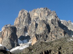
From the Austrian Hut cross the Lewis Glacier and scramble up the scree, which has many precariously balanced boulders and can be dangerous in half-light. Start climbing up a side groove about 55 m left of the obvious Brocherei Couloir. 18 m of easy climbing brings one to a wide, boulder-strewn ter­ race, at the left end of which is a gully (Donkey Walk) leading up to the left. Scramble up the gully for 25 m, then a mounting traverse back to the right up a series of easy ledges on the face.

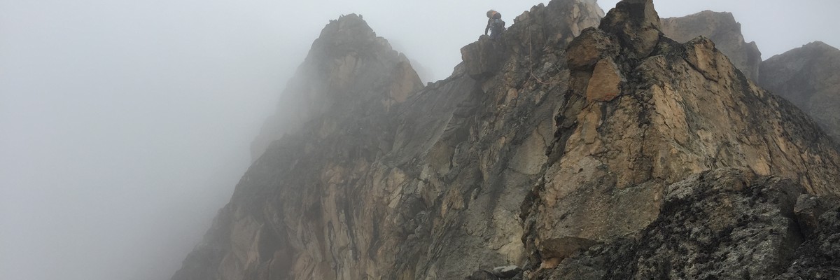
A move round a corner (III) leads to the foot of Mackinder’s Chimney. Instead of climbing the chimney, descend 21/2m and traverse right 6 m to a platform below the Rabbit Hole then climb a rib immediately right of the Rabbit Hole (III) and follow easy rocks to a platform at the top of Mackinder’s Chimney. One o’clock Gully (quite easy, unless ice-filled) now leads up right for 40 m. Where it steepens, mount the left wall then traverse back right to reach block steps leading up to the crest of the main ridge. When it appears obvious, make a long traverse right across slab then up toward the base of Mackinder’s Gendarme. A tin shelter (Baillie’s Bivi), is found just below the notch beneath Mackinder’s Gendarme on the main ridge. This is approximately half-way up Nelion. Turn the Gendarme on the left by first descending 7 to 10 m and then up a large gully.

Most parties nowadays follow the De Graaf's Variation, which is the easiest and most direct route (IV inf.). Avoid Shipton’s and Rickety Cracks by a traverse left for some 12 m out of a large gully, following the ascent of the square-cut groove for about 20 m and then straightforward climbing to the ridge leading to the Amphitheatre.

Alternatively, instead of traversing 12 m out of the large gully, continue up the gully to two short chimneys known as Shipton's Crack's (IV inf.), which lead to a small platform (Windy Gap), between the Gendarme and the main face, recent years many parties have found the traverse of the Gendarme the easiest and quickest way of reaching Windy Gap. From Windy Gap climb 2 m over a bulge on the face to reach a ledge; follow this right until peters out on the main face From here Rickety Crack (IV inf.) leads upwards for about 8 m to a platform. (A jammed nose of rock 2 m above the bottom of the crack can be used for protection on the first awkward exposed moves up the crack). Climb 30 m up a ridge to the right leading to a point overlooking the Amphithatre.

Belay at the edge of the Amphitheatre and climb down 8 m to the right (III). Work round the back wall of the Amphitheatre to cracks leading up left into the bed of the gully. Ascend the gully, much loose rock, for two pitches to a plat- form A 5 m wall is climbed by a shallow chimney (III), followed by a scramble over loose rock to a col overlooking the Diamond Glacier. Turn sharp right and up easy rocks to the summit of Nelion.

Variations: The Crack directly above Windy Gap has also been climbed out of season (Pfeffer and Pauer, August 1957). The chimney to the left of the point where the route traverses right into the Amphitheatre was climbed first by E. Sladen in 1938.

The summit of Batian is only 140 m away in a hori­zontal distance, but drop of nearly as many metres 'nto the Gate of the Mists is involved. The ridge may be followed from Nelion, traversing down on the north side, then turning towards the Gate. Keep under an overhanging cliff and descend to a boss of rock just above the Gate. Climb down this (III or IV), possibly leaving a rope to facilitate the return, as there’s usual­ly ice in the cracks. Cross the snow in the Gate (which may be corniced); as the icework is less than a rope’s length it is possi­ble to belay from either side. Traverse round the base of the Tower, on its north side, up scree or snow, and over the ridge behind the Tower onto the South Face of Batian. Ledges lead left across the face into a gully. This is then followed to the summit, but if it’s ice-filled take the wall to the right of the gully and chimney, taking care because of loose rock.

There is now a bolted abseiling route down Nelion. Follow arrows. Best done with 25 metre abseils. See here for details: https://www.summitpost.org/nelion-descent/160054

Major variations: Two variations have been done to join the Normal Route at Mackinder's Gendarme. 1a - East Ridge: This ridge of Nelion which rise from Flake Col consists of very loose shattered rock. Start 50 m left to the col and ascend ramp to ridge. The first four pitches are on poor rock and the fifth and sixth pitches are the most difficult. Climb the ridge then abseil into the top of the Brocherel Couloir and traverse to Mackinder's Gendarme. (A.G. Chinery and T. Welker, 14th Jan. 1965. Grade IV sup.).

1b - Brocherel Couloir: This prominent couloir right of the Normal Route start was climbed by P. Snyder and R. Collister in 1974. Grade V.

FA: E.E. Shipton & R Wyn Harris, 1929

Now-a-days most consider the route out of shape, but in 2005 we found a classic line which doesn't resemble the original route. I could not figure out where the original window used to be. It was a great alpine ice outing.

Start from Two Tarn Hut. Begin the climb near the top of the snow on the western side of the Darwin Glacier, where smooth, gentle slabs allow a rising traverse to be made into the notch between Point Slide and Batian. Easy climbing up the ridge until a traverse can be made across the amphithe­atre to the ridge bounding the West Face. Up the ridge to a steep buttress and up this (IV) to the crest of the ridge. Follow this to Batian. Time: 9 hour (to summit of Batian). Season: Christmas to mid-March

Variations: From the right side of the heed of the amphithe­atre, traverse left for two pitches to a weakness in the wall above. One pitch (IV inf.) leads to the foot of a diedre. Up this, turning an overhang on the right (3 aid move), and then continue vertically (V sup.), then slightly left (3 aid moves) onto a block. Step right, and traverse (V), to the foot of a black cor­ner. An elegant 35 m pitch (V) leads up this and the chimney above to the crest of the ridge (Merendi and Marimonti Jan 1958). The South-West Couloir which descends from the amphitheatre was climbed by starting from the snout of the Tyndall Glacier and ascending the left wall to a stance beneath a steep corner. Then up the crack, move right onto slabs and up left to a scree-covered ledge. Left up the gully and wide crack above to large slab. Climb the short wall on the right and continue right on a slab above the main coulior to its “Y” junc­ tion. Move left up a tributary ramp leading to easy slabs and the amphitheatre (P. Snyder and C Barton, Feb. 1972, Grade V inf.).

The South-West Couloir has been climbed in winter conditions (grade V, P. Snyder and I.F. Howell, Oct. 1974).

FA: A. H. Firmin & J.W. Howard, 1946

Season: Christmas to mid-March Time: 13 hours.

This route ascends the prominent ridge, which splits the hanging glaciers of the West Face, from the snowfield / amphitheatre on the South-West Ridge Route. The climb begins from the Tyndall Glacier, left the obvious rock buttress located immediately left of the South-West Couloir. The route works its way up the left side of this buttress to gain the ridge proper approximately 100 m below the prominent Lower Tower (situated lower left side of snowfield/amphitheatre). The major difficulties are low down on the route. From the start, three pitches (IV sup., IV, V), lead to a belay beneath a leftward curving arch. The route then ascends the wall on the left of the arch (V sup.) then breaks rightwards (A1) through an overhang onto easier ground. The route continues up, keeping left of the ridge, for three pitches (III, V, IV sup.), to reach the ridge proper beneath the Lower Tower.One long pitch (IV inf.) reaches the very base of the Tower. The route then leads rightwards on eas ground (good bivouac site), around the base of the Lower Tower (Il), then back leftwards above the Tower (Il), to gain ridge overlooking the West Face. Climb the ridge (Il) to the Upper Tower, which is climbed direct (IV). Continue up the ridge for four pitches (Ill sup., IV, Ill), to reach the South West Ridge. Follow this to summit.

FA: Z. Drlik, 1980

Start from Two Tarn Hut. Ascend the Tyndall Glacier to the foot of a steep snow-slope rising up rightwards between the two hanging glaciers, Forel (left) and Heim (right). Then climb directly up the snow/ice-field for about 250 m, making for a rib on the upper part of the face which is not too evident. Most parties pass to the right of it. Climb up to the right to a cave (bivouac site), and either make a long traverse left to the gully (IV inf.) which leads up to the summit; or climb up the rock (V) trending right to the South-West Ridge. The first three-quarters of the route used to require modern ice gear, but at time of writing (2023) the route probably needs reassessing as most glaciers have severely receded.

Time: 10 hours.

FA: R.A Caulkwell & G.W. Rose, 1995

Season: Mid-December to February. Time: 15 hours. This daring route is one of the most serious under- takings on the mountain. Start from Two Tarn Hut. A very narrow ice gully leads fromthe upper part of the Tyndall Glacier towards the left edge of the main serac barrier of the Forel Glacier. Climb this fully for four difficult pitches until an exposed traverse right allows one to gain a ramp, cutting rightwards through the seracs to the lowers snowfields of the glacier. If this ramp is not present the serac barrier could perhaps be bypassed on the left. On the first ascent an excellent bivouac site was found in the bergschrund on the left. Climb the slopes above to the highest point of the Forel, which can actually appear as a tiny snowfield in its own right. An intricate mixed pitch leads to the upper slopes, and further mixed climbing trending slightly right, leads to the upper slope of the South-West Ridge some 20 m from the summit.

FA: R. Barton & D. Morris, 1978

Season: Probably best during June to October. The season is critical as the foot of the couloir is rarely linked to the Tyndall Glacier. Standard: VI. The first ascent party felt the first two pitches warranted Scottish V. Time: 9 hours climbing time.

A bivouac was spent in bergschrund. This couloir, which might be better described as an icicle, lies to the left of The Untravelled World Route, and joins the Tyndall Glacier with the extreme left side of the Forel Glacier. The first two pitches are very steep. The ice then becomes easier angled and in five more pitches provides an exit right onto the main Forel. The bergschrund bivouac cave of The Untravelled World is then reached, and this route is followed to the summit.

FA: A. Hyslop & J. Tinker, 1980

Season: July to October. Time: 10 hours.

This route is the least difficult on the north side of the mountain. Start from Kami Hut, where a 40-minute walk below the foot of the North Ridge is made to the starting gully, which is marked by a cross in a circle chipped on rock. Climb straight up from the marker and move right at 6 m into the gully (IV inf.). Continue over easier rock until it’s possible to scram­ble for 90 m up the gully to a steep wall. An obvious crack brings one onto a large terrace beneath a third steep wall (III sup) Climb 6 m up an easy gully on the left, traverse back into the centre, then straight up (III sup.) and scramble into the Amphitheatre.

Scramble about 120 m across this until it steep­ens, in the direction of Firmin’s Tower, which is at the top left- hand corner. Climb 25 m to a wide sloping ledge (III), then tra­verse right along the ledge for 20 m (III), until it is possible to gain the ridge on the left-hand skyline. A 9 m scramble brings one to the foot of Firmin’s Tower. Climb the crack for 20 m to where it breaks into two branches. Chimney up the right-hand one for 15 m to the top of a massive loose block (overlooking the Amphitheatre).

Move left into the original chimney and continue up for 9 m. Scramble for about 18 m and up to the toD of the Tower (IV sup.)- Descend to the ridge and scramble along it for 60 m until it steepens. Continue along the ridge for another 30 m (IV inf.). Move up to an obvious ledge then traverse right to a small Amphitheatre (III). Further scrambling brings one to the junction of the West ridge where there is a superb bivouac site. Whilst it is possible to climb along the ridge it is easier and safer to traverse horizontally from the bivouac site for about 120 m to Shipton’s Notch. The rock in this area should be treated with care. This route is suitable for descent.

Variations: 1 - On the crux section of Firmin’s tower it's possible to move right from the loose block along an obvious ledge to the foot of a steep crack which is climbed direct (Grade V sup). 2 - The Firmin Tower has been bypassed to the right with a difficult and exposed mixed pitch above the Northey Glacier (V). the main ridge being rejoined just above the Tower (A. Schoon and H. Graafland, July 1958). 3 - A Japanese party made an ascent of the Kami Hut face of the North Ridge of Batian to join the North face Standard Route just below the tip of the gully before entering the Amphitheatre (1965). The whole of the North Ridge was climbed by J. Moss and J Linke in July 1974 (Grade V). 5 - From the starting point of the North Face Standard Route, the grey rock area immediately left of the gully was climbed for 15 pitches to the base of Firmin's Tower (M. Anglada and party, August 1971).

FA: A.H. Firmin & P. Hicks, 1944

Hello!

First time here?

theCrag.com is a free guide for rock climbing areas all over the world, collaboratively edited by keen rock climbers, boulderers and other nice folks.

You can log all your routes, connect and chat with other climbers and much more...

» go exploring, » learn more or » ask us a question

Accommodations nearby more Hide

Share this

Sat 29 Apr
Check out what is happening in Nelion and Batian.

Get a detailed insight with a timeline showing

  • Ticks by climbers like you
  • Discussions of the community
  • Updates to the index by our users
  • and many more things.

Login to see the timeline!

Deutsch English Español Français Italiano 한국어 Português 中文