Estacionalidad
Descripción
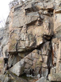
The Western Cwm is a group of cliffs around a cwm, containing a mixture of easy trad and sport up to some very hard sport.
The northern (left) side of the Cwm is currently open to climbing for most of the cliffs. Some cliffs in the center have been closed since about 2005. The southern (right) side of the Cwm has recently (fall 2010) been closed to climbing by the NCC.
Restricciones heredado de Eardley Escarpment
NEW ROUTE DEVELOPMENT IS NOT ALLOWED. DON'T DO IT.
https://ncc-ccn.gc.ca/places/rock-climbing links to https://ncc-website-2.s3.amazonaws.com/documents/Rock-Climbing-in-Gatineau-Park.pdf?mtime=20200113133647 which says, " Creating new routes is not permitted".
The Eardley Escarpment is contained in Gatineau Park, managed by the National Capital Commission (NCC). The NCC has closed climbing at all but a few of the crags. As of 2011, only Home Cliff (main corner area and rightwards to Piton Highway), Western Cwm (left or western side), the Twin Ribs (Copa Cabana and Down Under), and Eastern Block are open for climbing.
Cliff-top access is permitted only at Home Cliff and Western Cwm, at other crags climbs must be climbed from ground up.
The NCC, land-managers for Gatineau park, have a history of changing their web-page layout making direct-linking risky. As of fall 2018, their statement on climbing is available at: http://ncc-ccn.gc.ca/places/rock-climbing
While the origins of the closure was ecological sensitivity for the Eardley Escarpment (which is on the southern flank of the park), and originated as specific closures in that area, the current phrasing is a list of permitted areas within the park, meaning anything not in that list is, by omission, not open to climbing.
Acceso
From the Luskville Falls picnic area parking lot at the far end from the entrance, follow the equestrian/hiking trail down into a gorge, over a bridge and back out again. It will open out a bit on the left, and after a large boulder just to the right of the trail, there will be a trail (marked by a cairn and little wooden placards with a carabiner icon) leading up and right off the equestrian trail. Follow the trail until a metal signpost on a tree, and branch left and up at this point, skirting some gentle slabs along the left, until going up and over them (some directional carabiner signs). Off the back side of the slabs though a short wooded bit, then up a short scramble will lead to the cliff. The trail arrives at the section below Spindrift Wall and Cave Wall.
About 30 minutes.
Descenso
Rappel off anchors -- cliff-top access or down-hiking is not allowed.
Ética heredado de Eardley Escarpment
No new development or bolting allowed. Strong tradition of leaving trad routes trad, even if badly run-out.
Planifica tu viaje
¡Hola!
¿Es tu primera visita al sitio?
theCrag.com es una guía gratis de zonas de escalada de todo el mundo, editada de manera colaborativa por escaladores, bloqueros y otros amables entusiastas.Puedes registrar todas tus vías, ponerte en contacto y charlar con otros escaladores y mucho más...» descubre más, » más información or » haz una pregunta


Alojamientos cercanos more Ocultar
Compartir contenido
Iconos cercanos
| 5.3 | ★ Ground Zero | ||
| 5.4 | ★★ Route B | ||
| 5.6 | ★★ Neruda | ||
| 5.10d | ★★ Security |
Fotos Navegar por todas las fotos

Western Cwm - Shipinava Wall and Banana Republic
Western Cwm - Western Cwm - Reaper Buttress

Western Cwm - Western Cwm - Cave Wall
/44/4f/444fb9adbe93670c47bbd9bb11e2c6fafbb03fc1)
Spindrift Wall - IMG_4034.JPG
Jue 27 Abr
Echa un vistazo a lo que está ocurriendo en Western Cwm.
Get a detailed insight with a timeline showing
- Ticks by climbers like you
- Discussions of the community
- Updates to the index by our users
- and many more things.
Login to see the timeline!