A Crag Guide gives an extensive view of all sub areas and climbs at a point in the index. It shows a snapshot of the index heirachy, up to 300 climbs (or areas) on a single web page. It shows selected comments climbers have made on a recently submitted ascent.
At a minor crag level this should be suitable for printing and taking with you on a climbing trip as an adjunct to your guidebook.
This guide was generated anonymously. Login to show your logged ascents against each route.
Warning
Rock climbing is extremely dangerous and can result in serious injury or death. Users acting on any information directly or indirectly available from this site do so at their own risk.
This guide is compiled from a community of users and is presented without verification that the information is accurate or complete and is subject to system errors. By using this guide you acknowledge that the material described in this document is extremely dangerous, and that the content may be misleading or wrong. In particular there may be misdescriptions of routes, incorrectly drawn topo lines, incorrect difficulty ratings or incorrect or missing protection ratings. This includes both errors from the content and system errors.
Nobody has checked this particlular guide so you cannot rely on it's accuracy like you would a store bought guide.
You should not depend on any information gleaned from this guide for your personal safety.
You must keep this warning with the guide. For more information refer to our:
Usage policy
Contributors
Thanks to the following people who have contributed to this crag guide:
The size of a person's name reflects their Crag Karma, which is their level of contribution. You can help contribute to your local crag by adding descriptions, photos, topos and more.
Table of contents
- 1.
Phnom Kulen
26 in Area
-
1.1.
Kulen Basecamp 12 routes in Crag
- 1.1.1. Pagoda Cliff 3 routes in Cliff
-
1.1.2.
Camp Cliff 9 routes in Cliff
- 1.1.2.1. South West Tentsite 2 routes in Sector
- 1.1.2.2. North West Tentsite 7 routes in Sector
- 1.1.2.3. East Tentsite 0 routes in Sector
- 1.1.3. Pagoda parking cliff 0 routes in Cliff
- 1.2. Tmor Yeak 0 routes in Crag
-
1.3.
Phnom KomNob 10 routes in Crag
- 1.3.1. East side 0 routes in Cliff
- 1.3.2. Upper West side 4 routes in Cliff
-
1.3.3.
Lower West side 3 routes in Cliff
- 1.3.3.1. T'ngai Leyk Roof / Sunset Roof / ដំបូលថ្ងៃលិច 3 routes in Sector
-
1.3.4.
Entrance Road Boulders 3 routes in Field
- 1.3.4.1. Crescent Boulder 3 routes in Boulder
- 1.3.4.2. Midroad boulder 1 routes in Boulder
- 1.4. Poeung Dak Preah 4 routes in Crag
- 1.5. Blue house boulders 0 routes in Field
- 1.6. Peung Tanon 0 routes in Field
- 1.7. Peung Kom Nuo 0 routes in Field
-
1.1.
Kulen Basecamp 12 routes in Crag
- 2. Index by grade
1. Phnom Kulen
- Summary:
-
Escalade sportive, Escalade traditionnelle et autres styles
Lat / Long: 13.661158, 104.018582
résumé
The Kulen massif is a short drive north of Siem Reap and the Angkor Wat archeological park. Kulen might be the biggest potential for development of new crags in the nation.
description
Phnom Kulen is not one mountain but a small massif of many hills. Most of the massif is within a park and requires paid access for foreigners. There are several unexplored crags in the Kulen. Mine potential is high and exploration should NEVER be done without a significant knowledge of the area and taking appropriate safety measures.
Limitations de l'accès
Eastern Kulen $15-20 tickets for access. Western Kulen partially within Angkor Archeological park, park pass required. Hazard of landmines.
où dormir
Siem Reap, Svay Leu, or any of the many homestays around Kulen. There are also campgrounds within the park.
éthique
Most of Kulen requires purchasing daily park passes, please don't sneak in. Also bolting or alteration of cliffs is not welcome without first consulting Apsara authorities.
1.1. Kulen Basecamp
- Summary:
-
12 routes in Crag
La plupart Escalade sportiveLat / Long: 13.577756, 104.206145
résumé
A campground in the heart of Kulen with climbing, mountain biking, and hiking activities for all ages to enjoy. Stay and enjoy the amazing sunset views and peaceful srurroundings.
description
Location not yet announced. The Camp should open dry season 2022.
Limitations de l'accès
Must stay at the campground, cost not yet announced.
approche
Mildly difficult trail access from Ta Penh village, by foot or mountain bike.
où dormir
At the Kulen basecamp.
éthique
As this is private land please obey all rules set by the campground. The largest cliff is beneath a small wat. Please respect the monks activities and enjoy climbing while being mindful of your noise and presence.
1.1.1. Pagoda Cliff
- Summary:
-
Escalade sportive et Moulinette
3 routes in Cliff
description
The biggest cliff in the Eco-Camp area, the small pagoda sits at the top of the cliff.
approche
From the campground follow the trail west to the pagoda. To access the top pass through the pagoda to the big bare area, cliff faces west and north. To access the bottom follow the stairs to the east around the rock down to the bottom. At present the bottom is very full of garbage, be careful.
historique
The pagoda was inhabited by a hermit monk for over twenty years, the month that he died was the same month that the eco camp got the lease for the land. Local climbers from Siem Reap were invited to start development in May of 2022. This author had the pleasure of working with them to create a climbing area for the camp ground.
| Route | Grade | Style | Selected ascents | |||
|---|---|---|---|---|---|---|
| 1 |
Takes a little longer
Same as Making it Work, but don’t avoid the crux like a sissy. | 5.11 | 12m, 4 | |||
| 2 |
Making it work
Belay from the little slab at the base of the cliff, climb is characterized by pockets made from the sandstone layers. At the 4th clip there’s a large cave to the left, avoid it as some of the hermits live in there at times. Slightly run out between clips 3-4 because of the layers. Can cheat the crux by following the crack up to the right and traversing back over along the top to the anchors. FA: James Hugh Festeryga, 2 Juin 2022 | 5.8 | 12m, 4 | |||
| 3 |
I’m from Ontario so slab is kind of my jam
To the right of the lead climb there are top anchors on the face. Not super easy to access fro the top, but offers clear path for top rope not to rub too much. At the bottom there’s a gradually steepening slab covered in green slippery moss up to the first ledge. Pretty straightforward from there. Lead climb bolting was abandoned due to the hollow quality of the rock. FA: James Hugh Festeryga, 2 Juin 2022 | 5.7 | 12m | |||
1.1.2. Camp Cliff
- Summary:
-
La plupart Escalade sportive
9 routes in Cliff
description
The cliffs lining the campground, especially to the north. Very short climbs, up to 5m, but bolted for safety.
approche
Between the tenting spots on the north side of the campground there are access paths to the cliff bases.
historique
The campground development began in early 2022. May of 2022 local Siem Reap climbers began clearing out the bottom of the camp cliffs. Several high boulder routes were discovered, for the sake of safety they were developed as lead climbs.
1.1.2.1. South West Tentsite
- Summary:
-
2 routes in Sector
Tous Escalade sportive
description
The tent site furthest to the north west.
| Route | Grade | Style | Selected ascents | |||
|---|---|---|---|---|---|---|
| 1 |
CoolEh?N
Start with hands on the face, feet under the overhang. Crimp up to the slopey pockets. In the deep pocket be prepared to have 1000 ants on you within seconds, can switch grip in the ant pocket to undercling. Top out on big jug in between the two anchor bolts. FA: James Hugh Festeryga, 2 Juin 2022 | 5.6 | 5m, 2 | |||
| 2 |
Downspout
Climb to the southern anchor. Really green and slippery on account of the water trickle here that created a perfect cleft in the top of the rock, the downspout. FA: James Hugh Festeryga, 2 Juin 2022 | 5.4 | 5m, 1 | |||
1.1.2.2. North West Tentsite
- Summary:
-
7 routes in Sector
La plupart Escalade sportive
description
The tent site to the North West (beside the South West site)
| Route | Grade | Style | Selected ascents | |||
|---|---|---|---|---|---|---|
| 1 |
The corner
On the corner of the rock, furthest to the south. FA: Buth, 2 Juin 2022 | 5.6 | 4m | |||
| 2 |
Little roof
Next to the layback crack there is a little roof. Should be a climb here. | 5m | ||||
| 3 |
See ya pows!
A nice layback crack almost the length of the route. Hits a teeny tiny roof one meter below the anchors. | 4m | ||||
| 4 |
Blown Wide Open
Under the big tree there is an obvious yellow crack, there are anchors but tying to the big branch will save your rope a lot of friction. Hand shredding project on explosive sandstone. We’ve blown off more holds than there are on the route. The crux is early, best guess is to reach deep in the yellow coloured crack for a slopey side grip. Recommend listening to tunes by Big Wreck to bring the psyche. | 5m | ||||
| 5 |
8 Ball
Start in front of the big red barked tree. (For top rope recommend anchoring in the tree, actually, save your rope a lot of trouble). Big pocket on the right gets you of the ground, big pocket above your head gets you to the first bolt. Straight forward slopey stuff from there. Very bouldery route. | 5m, 2 | ||||
| 6 |
Kroma Crashpad
Far end of the sector is a project that ideally one would have a few crash pads for. Start with a traverse on the overhung start until your back is almost touching the boulder behind you. A fall early results in a boulder bump, hence why a crashpad is ideal. Transition from pockets to crimps to slopes to achieve the steep slab top. Anchors in the rock BUT a top rope attempt will absolutely shred a rope. | 6m, 3 | ||||
| 7 |
Halfway there
Same top as Kroma Crashpad, start from on top of the boulder to skip all the hard stuff. | 4m, 2 | ||||
1.1.2.3. East Tentsite
description
Tentsite to the east is on top of a large overhanging ledge. Bouldering possible underneath.
1.1.3. Pagoda parking cliff
description
New cliff, unexplored, plans to bolt and anchor and abseil in for a look.
approche
From the flat “parking” area at the pagoda head a few meters down trail to the little rocky lookout, you’re at the top. No word yet on bottom access.
historique
Kimsroy and James noticed on a recon walk. Because the trees at the base were so tall we assumed it was only a couple of meters tall. Turns out it’s a lot taller than expected.
1.2. Tmor Yeak
résumé
A very large boulder visible from the road about halfway up the switchbacks from Svay Leu into the Kulen. A smaller boulder balanced on top makes it look like a rock giant, hence the name.
description
Very little exploration has been done of Tmor Yeak. There are several smaller boulders around it that should yield good bouldering. The yeak itself is estimated 8-10m high with very little reliable protection on it. Most likely will become a sport area.
Limitations de l'accès
Minor scramble from the road. There is a very large gravel shoulder where the access is, giving ample parking (though not necessarily reliably safe parking.) The boulder field is before the ticket checkpoint, so there is no access cost, BUT it may still be technically within the Apsara zone, which means use may be frowned upon, no confirmation of that as of this writing.
approche
So far the best intel is to bush bash and boulder your way to the base (up to V3 difficulty). A way may yet be found that requires no climbing.
historique
Seam Rorn, Kimsroy, and James were coming back from a development trip at Kulen Base camp in 2022 and they decided to pull over on an outcrop and have a look through the binoculars at some cliffs and boulder fields. Tmor Yeak stood out as an obviously interesting rock formation, though from the road it looked like a scramble. So our intrepid explorers set out to hike to the top. As it turns out another large boulder was obscuring the view, and once on top of that boulder it was clear what Tmor Yeak truly was: a massive overhung boulder with route potential 360 degrees around it. The rock itself along with the other boulders in the area and close access to the road make Tmor Yeak (in this authors opinion) one of the best potential development sites in the country. Development has yet to begin as of this writing.
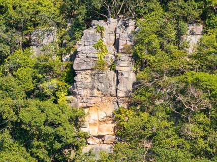
1.3. Phnom KomNob
- Summary:
-
Moulinette, Escalade traditionnelle et Bloc
Lat / Long: 13.636378, 104.024149
résumé
A small side summit just off the main bulk of Kulen.
description
Note: no climbs develloped at time of writing. Potential project site. Phnom KomNob has the major benefit of being outside the national park (so no park passes or fees) while still being basically part of the Kulen massif. It is the same red sandstone that is the hallmark of Kulen. Running north-south it has sunrise and sunset views, the east side looks down into the beautiful Kulen central valley where the main tourist sites are, the more prominent west side has clear views of endless rice fields, Siem Reap, the western length of Kulen, and on a really clear day one can even make out sites in Angkor.
Eastern rock: lots of overhanging blocks, many cracks shooting in all directions, could be a trad climb haven. Looks slightly precarious, several death blocks hanging in space. Western rock: smoother, more solid feeling, but
Limitations de l'accès
The whole mountain is under control of the Wat at the bottom. There is an ancient prasat on top and hermit monks live throughout the jungle on the hill. Need to be very careful not to distrub the peace. They are welcoming, quite happy for anyone to go for a hike. So far the monks themselves seem only bemused by our climbing gear and abseils, the security guards less so. Tread lightly. They DO NOT like people remaining after dark.
approche
Find it on google as Kom Nob Temple. The only access is through the Wat. Park next to the little shop across the large open space directly in front of you as you enter the front gate. Customary to pay 2000-5000 riel for parking. First timers should access the top via the obvious staircase at the far end opposite the entrance gate. The stairs end at some buildings mid-way up the hill, just ask anyone for the trail head to see the prasat on top, they'll steer you to an easily missed trail, follow up then left along the base of the cliff. Near the end of the cliff line is a concrete staircase up a nearly vertical cliff, then short walk to the prasat (ancient brick one room temple). Pass by the prasat, then the big flagpole and Naga statue, can't miss the main cliff/viewpoint on the left. If you continue past it there are a series of forking trails all the way back down to the main wat, it lets out behind some of the monks houses. Once you know that way it is a much faster top access. For the smaller cliffs there is a fork off the main trail just down from the main cliff, before the steepest last section of the trail turn north. That trail is less used, be careful not to get lost following a logger trail (speaking from experience).
où dormir
Only 1h15min. from Siem Reap. Though Wats are usually good about letting you stay the night if you need, and you don't mind sleeping on the floor. Just ask,
éthique
Like most climbing areas in Cambodia it is dotted with buddhist holy sites and shrines. Do not climb anything with carvings or statues, be sensitive to the monks activities, always be polite and if they say no just listen, it's their land.
1.3.1. East side
description
Red sandstone, lots of natural protection available. Could be a good trad site. Untested, many potential death blocks, and it looks geologically young, sort of "fresh" like a massive section fell off just in the last couple hundred years.
There are some worthwile boulder on the way up under the high canopy area before you meet the cliff base.
approche
Follow the stairs from the main wat at ground level, then a small hard to find trail from the mid-way wat. The main trail to the ancient wat on top follows the base of the cliffline.
1.3.2. Upper West side
- Summary:
-
4 routes in Cliff
Tous MoulinetteLat / Long: 13.632933, 104.023441
description
The highest point on the hill, and most prominent view. Only a few climbable sections of cliff, with sketchy belays since the slope is still very steep from the bottom of the actual rock face.
approche
A few steps from the shrines on top (both ancient and modern). No bottom access discovered yet.
 |
||||||||
| Route | Grade | Style | Selected ascents | |||||
|---|---|---|---|---|---|---|---|---|
| 1 |
Hidden Treasure
Straight down from the main promontory slightly to the right (south) there is a hand sized crack that is hidden by a small tree growing out from the rock. Debating the ethics of cutting the tree. Route starts from the same block as Antal's route and Nosey project, lower than that is just high angle dirt slope. | 21m | ||||||
| 2 |
Stretchy In The Dark
Starting on the same block as Hidden Treasure traverse left when the route gets overhanging, traverse back right to escape into the small notch beside the main promontory. FA: Antal Gabelics, 3 Déc 2023 | 21m | ||||||
| 3 |
★ Nosey
When standing on the promontory furthest out going down the right side is a smooth nose like corner. Below the nose is a blocky roof with a few deep ledges. Climb really starts from the block about 10m off the ground, 21m ish from the top. | 21m | ||||||
| 4 | Possible route up the side | 22m | ||||||
1.3.3. Lower West side
- Summary:
-
3 routes in Cliff
Tous Escalade traditionnelleLat / Long: 13.638681, 104.020825
description
A little more than half the height of the upper west side, much longer cliff with more potential and better belays.
approche
the last fork on the hike up (jungle trail, not eastern cliff trail) turn right (north). Trail is not well travelled or marked, be careful. There is a bottom access if you turn left at the massive tree you meet when you first see clifftop. This area is largely unexplored.
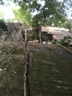
1.3.3.1. T'ngai Leyk Roof
- Summary:
-
3 routes in Sector
description
A square carved into an otherwise fairly vertical cliff. Beautiful white sandstone stained red from the higher layers make a sunburst pattern, also it's a perfect ledge to sit and watch the sunset, which it face directly. ដំបូលថ្ងៃលិច (T'ngai Leyk) means sunset.
approche
Middle of the lower west side. Access bottom using the stone staircase near the big tree. Access top byt continuing past the stone staircase.
 |
||||||||
| Route | Grade | Style | Selected ascents | |||||
|---|---|---|---|---|---|---|---|---|
| 1 |
Sunset roof left
Unknown length. Can be belayed from the ground or from the ledge inside the roof (which would shorten the route by 5 ish meters.) Flat green mossy face from the ground to the ledge. Thin crack in the dihedral to the roof. Decent looking hand crack out of the roof. Haven't see above it yet. | |||||||
| 2 |
Sunset roof right
Unknown height. Can be belayed from the ground or the ledge under the rood (that would remove 5ish meters). On the right side of the square where the ledge continues out of the square. Either dihedral face climb to the roof then hand? crack out, or climb the arete direcctly to the edge of the roof. Hand crack up from the roof. | |||||||
| 3 |
Sunset roof right arete
Same as Sunset roof right but climb the arrete to avoid the roof. | |||||||
1.3.4. Entrance Road Boulders
- Summary:
-
3 routes in Field
Tous BlocLat / Long: 13.649700, 104.021929
résumé
The boulders along the road into the Phnom Kom Nob wat.
description
Dark grey/red sandstone blobs. Very slopey. A few nice lines accesible right off the road. Downclimbs are sketchy.
1.3.4.1. Crescent Boulder
- Summary:
-
3 routes in Boulder
Lat / Long: 13.649702, 104.021608
description
Leaning into the road, obvious line on the front with crescent moon like feature near the top.
approche
Stop the car/motorbike, step out, climb
| Route | Grade | Style | Selected ascents | |||
|---|---|---|---|---|---|---|
| 1 |
★★★ Crescent
Very obvious line on the boulder that juts out into the road. Cannot get to Phnom KomNob without passing by this beauty. Start low feet hands in crater at chest height. Step into crater with strong undercling in the top to move within reach of the crescent shape up to the left. Dyno option very cool, maybe harder than static move, but maybe not. FA: Bale Huy & Asai, 13 Jan | V5 | 4m | |||
| 2 |
Downclimb side
There are nice footholds, and general smeary slabs to go up the right side of the boulder. It's also the easiest way down, though it takes some nerve. | 4m | ||||
1.3.4.2. Midroad boulder
- Summary:
-
1 route in Boulder
Lat / Long: 13.649698, 104.022253
description
Big boulder in the middle of the road
approche
Park car, walk to the middle of the road
| Route | Grade | Style | Selected ascents | |||
|---|---|---|---|---|---|---|
| 1 |
Toward the wat side
Seems like some pockets on the side of the boulder towards the wat would yield a line. No known attempts yet. | 4m | ||||
1.4. Poeung Dak Preah
- Summary:
-
4 routes in Crag
Escalade traditionnelle et MoulinetteLat / Long: 13.545130, 104.224501
résumé
The highest cliff in Kulen (we think) with direct eastern views and amazing sunrise.
description
Huge sandtone cliff formed as massive blocks broke away from the mound that is Kulen. Several deep cracks run along the cliff top showing that more blocks will fall away some day, revealing a whole new cliff again. Let's just hope it's not while we're climbing it. The sandstone is very succeptible to water smoothing it out, and so is mostly festurless, except for the amazing red and black streaks. Occasional off width cracks go the whole way, but at time of writing no awesome splitters have been found.
Limitations de l'accès
Jungle covers the bottom, bring a machete. Privatisation of the National Park, police, farmlands, and local tourguides cover the top. Access is tenuous. And land mines, suposedly this area is all clear, but you never know.
approche
From Svay leu follow the switchback road up (it's the only road, can't miss it). First time out hire a guide, you will get lost in the cashew farmers weaving trails. Top is beautiful, but dangerous. Huge deep cracks drop down between the blocks well back from the actual cliff edge. There is a "trail" along the entire base of the cliff, a access point drops into it not far from the main road. Many caves, some not visible becuase of underbrush, be careful, bring a guide.
où dormir
Svay Leu. Kulen Basecamp. Word on the street is there is a deal being made with a farmer a the cliff base for a climbers camp.
| Route | Grade | Style | Selected ascents | |||
|---|---|---|---|---|---|---|
| 1 |
Solid Maybe - open project
Beneath the extremely overhung roof that tops the cliff about 50-60m to the south-west of the main prow. Starts with a traverse right along a ledge to a hand crack that leads to a small roof, then another traverse left? or right? to a face climb top out. The headwall is a big question mark. Face climbing, maybe goes. looks liek there could be another crack up high but hard to see from the bottom. | 25m | ||||
| 2 |
Freedom from Java
Off the North side of the main prow (left when looking from the top toward the edge) there is a line that might go, sort of follows a banyan tree that has exploited the same weakness in the rock. Could sling the tree at points if pro becomes sparse. There is a big rock on top of the flat outlook portion of the cliff, if you wrap it it could be a suitabe anchor to project this climb. Not sure if the pro goes or if bolts will be involved. | 30m | ||||
| 3 |
The abseil corner - Open project
Alternating from a cave entrance to a chimney to a flaring offwidth and back through it all again maybe twice. It's not a great looking climb, but it looks do-able. maybe not protectable though. (Marked as top rope project, not sure if it's protectable). Tree at the top is our usual abseil anchor for accessing the bottom. | 30m | ||||
| 4 |
Too leafy, for now - Open project
Length can vary depending if you start down in the pit, or from the lip of the pit. Maybe 5m longer. Looks o be a full continuous crack up a dihedral all the way from bottom to top. At least what we can see of it, needs some gardening. Needs big cams (unsure what size). | 25m | ||||
1.5. Blue house boulders
résumé
Boulder field next to a farmers house at the base of Poeung Dak Preah. The owners name is Soem Savy.
description
Lovely little sandstone boulders that rolled down from the cliff eons ago. Very much shaped by the rain. Mostly short. Savy, the farmer, keeps the grass cut around them and has a ladder or two for top access.
Limitations de l'accès
Private land, talk to the Savy first. To get in touch with him contact Kingdom Climbign Gym in Siem Reap.
approche
Beside Svay Leu High School, to the south, is a red dirt road. Follow it all the way to the end.
où dormir
Savy, the farmer, allows camping among the boulders, pay him a few dollars. Only 1.5h drive from Siem Reap. Guest houses in Svay Leu.
éthique
Remember it's private land, right now the farmer is happy to let us access it, just ask permission first.
historique
Looking over photos from his first trip to Peoung Dak Preah James noticed a little boulder field that had been cleared of jungle but not dynamited to make farmlands. A bright blue roof was clear in the photos, and on google satelite search. Seam Rorn and James set out to meet the locals and start dicussions about access, possible camping, even building some bamboo huts came up. A promising partnership was born.
1.6. Peung Tanon
résumé
Red sandstone pillars dot a field on a high point at the far west end of the Kulen massif.
description
The stone is extremely rounded by centuries of rain, creating odd bulbous shapes, and hard slopey routes.
Limitations de l'accès
Access is open, but the area is under the supervision of the local wat. Don't climb above shrines.
approche
Follow google maps to the Peung Tanon Resort at the north side of the hill, continue up the dirt road. Park cars near the wat, continue on foot. Dirt bikes can go all the way up. Alternatively from the south on motorbike you can take the road through all the farm fields. The "road" becomes less and less a road and more a trail as you go.
où dormir
Peung Tanon resort. About 1.5h from Siem Reap.
éthique
The usual protocols and ethics around wat land.
1.7. Peung Kom Nuo
résumé
A vast boulder field with ancient carvings on some of the boulders.
description
Lots of talus from Kulen that got pretty far from the main cliff was the site of some impressive carving from the Angkor era. These carvings are protected DO NOT CLIMB ON THEM. The best climbable boulders are to the north end beside a farmers house. He burns the grass around them to keep grazing space for his cattle. Several extreme overhangs, but the sandstone is mostly slopey and not idea for roof climbing.
Limitations de l'accès
A wat exists to protect the carvings. Be respectful. Do not climb any boulders with carvings on them. Many boulders are on private land, if you see a farmer be friendly and ask permission to be there.
approche
Park cars by the corner store on the main road, motos can go in all the way to the boulders. The young lad at the corner store will show you the way in, tip him $1-$2.