A Crag Guide gives an extensive view of all sub areas and climbs at a point in the index. It shows a snapshot of the index heirachy, up to 300 climbs (or areas) on a single web page. It shows selected comments climbers have made on a recently submitted ascent.
At a minor crag level this should be suitable for printing and taking with you on a climbing trip as an adjunct to your guidebook.
This guide was generated anonymously. Login to show your logged ascents against each route.
Warning
Rock climbing is extremely dangerous and can result in serious injury or death. Users acting on any information directly or indirectly available from this site do so at their own risk.
This guide is compiled from a community of users and is presented without verification that the information is accurate or complete and is subject to system errors. By using this guide you acknowledge that the material described in this document is extremely dangerous, and that the content may be misleading or wrong. In particular there may be misdescriptions of routes, incorrectly drawn topo lines, incorrect difficulty ratings or incorrect or missing protection ratings. This includes both errors from the content and system errors.
Nobody has checked this particlular guide so you cannot rely on it's accuracy like you would a store bought guide.
You should not depend on any information gleaned from this guide for your personal safety.
You must keep this warning with the guide. For more information refer to our:
Usage policy
Contributors
Thanks to the following people who have contributed to this crag guide:
The size of a person's name reflects their Crag Karma, which is their level of contribution. You can help contribute to your local crag by adding descriptions, photos, topos and more.
Table of contents
- 1. Kefala 7 in Sector
- 2. Index by grade
1. Kefala
- Summary:
-
All Escalada esportiva
Lat / Long: 37.039137, 26.920177
- PREPARE to leave nothing behind (trashbag, etc).
- Use your own gear for toproping. Use fixed gear only for lowering. (See first section of guidebook for details.)
- Minimize single-use plastic. No recycling on the island (yet).
- Use established paths and close gates behind you.
- Consider a donation to the rescue team (red boxes).
descrição
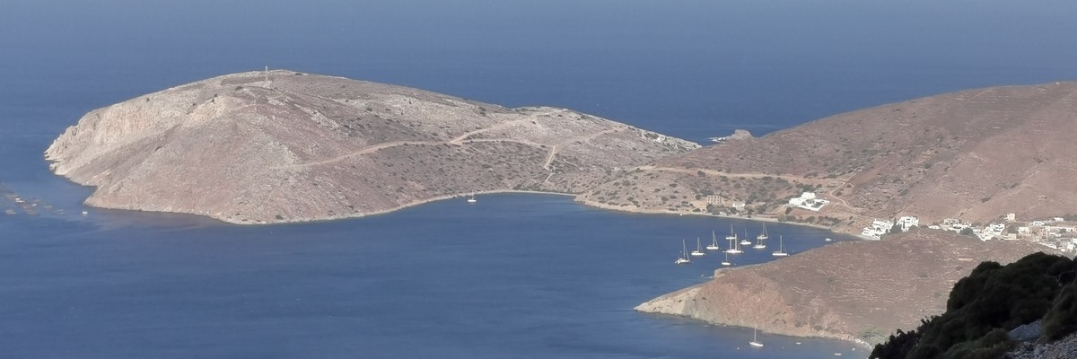
A small rarely visited crag, located on Kefala Cape, the small offshore peninsula in front of Emporios village.
 In the shade only after 18:00.
acesso
 Drive all the way through Emporios. After passing St George Church at the village, take the dirt road to the right, leading towards Kefala peninsula (37.0461654, 26.9266189). Continue for about 900 m, passing the intersection to two small beaches on the left and right. At the next T intersection, take the sharp turn to left and continue for another 600 m. Park at the end of the road end (37.0401709, 26.9239061).
 Walk right around the hillside for about 300 m to the cliff.
ética
história
Equipped in 2015 by Luca Salsotto, Thierry Bionda and André Langenbach.
 |
||||||||
| Route | Grade | Style | Selected ascents | |||||
|---|---|---|---|---|---|---|---|---|
| 1 |
Aucune Idée
Set: Thierry Bionda, 2015 | 5b | 25m | |||||
| 2 |
Gorges Pompidou
Set: Thierry Bionda, 2015 | 6a+ | 25m | |||||
| 3 |
J'Équipe l'Île
Leads up the groove on the right wall. Set: Luca Salsotto & André Langenbach, 2015 | 6a | 42m | |||||
| 4 |
No Name
New route. Name, length and grade unknown (2023). Set: Christian Lemrich | |||||||
| 5 |
Fuori Programma
Set: Luca Salsotto, Thierry Bionda & André Langenbach, 2015 | 5c | 30m | |||||
| 6 |
Tomy Superstar
Set: Luca Salsotto, Thierry Bionda & André Langenbach, 2015 | 5c | 30m | |||||
| 7 |
Festival Off
Set: Luca Salsotto, Thierry Bionda & André Langenbach, 2015 | 6a+ | 25m | |||||
2. Index by grade
| Grade | Stars | Name | Style | Pop | |
|---|---|---|---|---|---|
| 5b | Aucune Idée | 25m | |||
| 5c | Fuori Programma | 30m | |||
| Tomy Superstar | 30m | ||||
| 6a | J'Équipe l'Île | 42m | |||
| 6a+ | Festival Off | 25m | |||
| Gorges Pompidou | 25m | ||||
| ? | No Name |