Use this Region Guide to easily find and compare Crags.
Table of contents
- 1.
North Shore
2092 in Region
-
1.1.
Blues Point 56 in Crag
- 1.1.1. Life Aquatic Wall 39 in Cliff
- 1.1.2. Kung Fu Captin Wall 9 in Cliff
- 1.1.3. Peeking Patch 8 in Cliff
-
1.2.
Kurraba Point 26 in Area
- 1.2.1. Harbour Side Slabs 26 in Crag
-
1.3.
The Spit 84 in Area
- 1.3.1. Sandy Bay 43 in Crag
- 1.3.2. Pearl Bay 35 in Crag
- 1.3.3. Castle Rock Beach 4 in Crag
- 1.3.4. Parriwi Road Mosman 2 in Crag
-
1.4.
Clifton Gardens 6 in Crag
- 1.4.1. Northwest Overhanging Cave 3 in Crag
- 1.4.2. Southwest wall 3 in Crag
- 1.5. Obelisk Beach 10 in Crag
-
1.6.
Balmoral 14 in Crag
- 1.6.1. Lawry Plunkett Reserve 10 in Crag
- 1.6.2. Balmoral Island 1 in Boulder
-
1.7.
Cremorne 30 in Region
- 1.7.1. Brightmore Reserve 17 in Crag
- 1.7.2. Primrose Park 13 in Unknown
-
1.8.
Cammeray 36 in Area
- 1.8.1. Tunks Park 36 in Crag
-
1.9.
Bicentennial Reserve / Henry Lawson Cave 14 in Crag
- 1.9.1. Left of Cave 5 in Boulder
- 1.9.2. Far Left 1 in Area
- 1.9.3. Right of Cave 7 in Boulder
- 1.9.4. Gouda Rocks 1 in Area
-
1.10.
St Leonards 39 in Area
- 1.10.1. Climb-Fit 39 in Gym
-
1.11.
Castlecrag 7 in Area
- 1.11.1. Sunnyside 7 in Crag
-
1.12.
Middle Cove 99 in Area
- 1.12.1. The Chief's 23 in Boulder
- 1.12.2. Gleno Gate 0 in Boulder
- 1.12.3. Harold Reid Reserve 75 in Area
- 1.12.4. Three Brewskis 1 in Crag
-
1.13.
Castle Cove 12 in Area
- 1.13.1. Castle Cove crag / Right of Way Crag 11 in Crag
- 1.13.2. Echo Point 1 in Area
-
1.14.
West Roseville 13 in Crag
- 1.14.1. Graffiti Wall 5 in Sector
-
1.15.
Lindfield Rocks 230 in Crag
- 1.15.1. Trail Boulders 17 in Area
- 1.15.2. Very First Wall 2 in Area
- 1.15.3. First Wall 10 in Cliff
- 1.15.4. Walkdown Wall 17 in Cliff
- 1.15.5. Kenny Boulder 30 in Boulder
- 1.15.6. The Downclimb Slab 2 in Cliff
- 1.15.7. Four Cracks Wall 19 in Cliff
- 1.15.8. Abseil Wall 15 in Cliff
- 1.15.9. Black Wall/Wide Crack Area 13 in Cliff
- 1.15.10. One Hold Wall 12 in Cliff
- 1.15.11. Pipeline Wall 22 in Cliff
- 1.15.12. Bum Crack/Pocketed Face 8 in Boulder
- 1.15.13. Orange Face/Slab Side 9 in Boulder
- 1.15.14. She-Oak Wall 17 in Cliff
- 1.15.15. Isolated Rock/Overhang 15 in Boulder
- 1.15.16. The Overhangs 12 in Cliff
- 1.15.17. Pipe Dreams 10 in Cliff
- 1.16. Lindfield West 24 in Crag
-
1.17.
Chatswood West 36 in Region
- 1.17.1. The Deli 36 in Crag
-
1.18.
Killara 88 in Area
- 1.18.1. The Big Pump / Mummy Dust Cave 32 in Crag
- 1.18.2. The Block 37 in Crag
- 1.18.3. The vape cave 7 in Boulder
- 1.18.4. Sterlo 12 in Area
-
1.19.
St Ives 17 in Area
- 1.19.1. Fragmented Heart 6 in Crag
- 1.19.2. Bottle Neck 11 in Cliff
-
1.20.
East Killara 294 in Area
- 1.20.1. The Promised Land / Crispy 213 in Crag
- 1.20.2. The Queen's Hang Out 11 in Area
- 1.20.3. Queen's Country 37 in Crag
- 1.20.4. God's Country 33 in Crag
-
1.21.
Killarney Heights 45 in Crag
- 1.21.1. Project Wall 8 in Crag
- 1.21.2. Crumbly 37 in Crag
-
1.22.
Forestville 316 in Area
- 1.22.1. Sissy Crag 166 in Crag
- 1.22.2. The Wall 13 in Crag
- 1.22.3. Fox Cave 25 in Crag
- 1.22.4. The Frontyard 49 in Crag
- 1.22.5. The Backyard 0 in Crag
- 1.22.6. Upper Sissy 63 in Area
-
1.23.
Wahroonga 106 in Area
- 1.23.1. Browns Road 85 in Crag
- 1.23.2. Comenarra Parkway 1 in Crag
- 1.23.3. Lorna Pass 20 in Crag
-
1.24.
North Wahroonga 102 in Unknown
- 1.24.1. Wahroonga Rocks 102 in Cliff
- 1.25. Greenwich 12 in Crag
-
1.26.
Lane Cove 49 in Area
- 1.26.1. 9 Degrees Lane Cove 0 in Gym
- 1.26.2. Blackman Park 14 in Crag
- 1.26.3. 8 Degrees Lane Cove 18 in Crag
- 1.26.4. Southern Terrace 17 in Crag
-
1.27.
Riverview 58 in Unknown
- 1.27.1. Tambourine Bay 58 in Area
-
1.28.
Waverton 9 in Crag
- 1.28.1. Main Wall 5 in Sector
- 1.28.2. Stair side 4 in Sector
-
1.29.
Belrose 91 in Area
- 1.29.1. Belrose Crag 40 in Crag
- 1.29.2. Davidson 1 in Crag
- 1.29.3. Satan / Happy Valley 21 in Area
- 1.29.4. 616 29 in Crag
-
1.30.
Twin Creeks 26 in Crag
- 1.30.1. The chips 3 in Area
-
1.31.
Timbarra Boulders 46 in Crag
- 1.31.1. The Throne 16 in Boulder
- 1.31.2. Flagship Boulder 4 in Boulder
- 1.31.3. Stranger Things 10 in Boulder
- 1.31.4. Man of Steel 8 in Boulder
- 1.31.5. The Castanet 1 in Cliff
- 1.31.6. Overhangs 7 in Area
-
1.32.
Balls Head 96 in Crag
- 1.32.1. The Big Block 7 in Cliff
- 1.32.2. Central Buttress 7 in Cliff
- 1.32.3. When Crags Collide 82 in Crag
- 1.33. Get Bent 0 in Boulder
-
1.34.
Berry Island Reserve 1 in Area
- 1.34.1. Deep Bush 1 in Area
- 1.34.2. West Side Beach Boulders 0 in Area
-
1.1.
Blues Point 56 in Crag
1. North Shore 2,092 routes in Region
- Summary:
-
La plupart Bloc
Lat / Long: -33.775265, 151.355410
résumé
Bouldering, lead and trad on good quality sandstone.
description
The North Shore has something on offer for all lovers of chalk and rock. There's the Old classic spots like the amazing highballs at Lindfield Rocks, Pumpy much loved problems of Sissy Crag and some brilliant trad at Brown's Road.
New to the Area is the Lindfield-like When Crags Collide, the diverse, unappreciated Blues Point and some Slab-tastic climbing at Harbour Side Slabs.
Limitations de l'accès
If you have benefited from climbing infrastructure in NSW, please consider making a donation towards maintenance costs. The Sydney Rockclimbing Club Rebolting Fund finances the replacement of old bolts on existing climbs and the maintenance of other hardware such as fixed ropes and anchors. The SRC purchases hardware, such as bolts and glue, and distributes them to volunteer rebolters across the state of New South Wales. For more information, including donation details, visit https://sydneyrockies.org.au/rebolting/
éthique
Respecting the enviroment and keeping crags clean will maintain a healthy and important relationship between the climbing community, local councils and National Parks. Carry out what you take in and enjoy what the North Shore has to offer.
If you come across an area that is being developed or you think could be under development, please show all due respect to the developers and do not climb the projects listed on thecrag.com.
historique
The North Shore has seen some amazing climbs and problems put up over time with a slump in its development during the early 2000s.
However that all changed with the turn of the decade seeing the start of the Great Bouldering Boom with the North Shore getting some much needed development attention by a group of enthusiastic lovers of rock.
The word on the street is that this attention will only increase as the years go by, making the North Shore a strong epicenter of climbing in Sydney
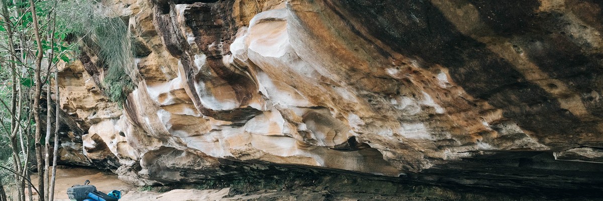
1.1. Blues Point 56 routes in Crag
- Summary:
-
La plupart Bloc
Lat / Long: -33.849978, 151.203218
description
A 35m long quarried cliff that has a mass of good, unappreciated boulder problems on it. A few great mantles and some V1's makes this place good for beginners, with a few harder problems scattered throughout.
We all started out as beginners so some VERY easy problems have been developed for those just discovering the love of rock. Become comfortable with the rock, then face the battle of the psychological challange.
With the Harbour Bridge to your right and the harbours water's lapping behind you, this crag will offer you more than just a good climb, it'll offer you some amazing views as well!
Most problems finish halfway up the wall. Of course if one wants to, all problems can be topped out, with more highballs being developed all the time.
News Flash: Blues Point now new and improved with added top rope problems! Gear not included.
Council have also placed a permanent wheelie bin at the base of the crag next to Letterbox Crack. Ensure care is taken when traversing I Can See The Clock But I Don't Know What The Time Is .
approche
Drive, ride or walk down to the end of Blues Point Road where you'll hit a car park with an awesome view of the Harbour Bridge and city.
Walk through Blues Point Reserve, past the play ground and toilets and then round the point past all the fishermen. In under 2 minutes you've come across the first wall with two more only meters away.
historique
Well hello there I'm glad you stopped by. Why don't you take a seat and I'll tell you a story of how it all began.
Now being so close to the city and with the iconic over hang of Balls Head on the opposing shore, Blues Point has been crawled over for years but until recently very few routes had been developed with almost no beta being placed in guide books or online.
Blues Point was first develoepd by Brendon Allan Flanagan in early 2011 and was his first ever 'crag project'. Then in 2012 from sunny Queensland came Ranger Dave who found Blues Point on another climbing web site which will not be mentioned because as we know thecrag.com is the best!
Ranger Daves keen eye for detail could see that Blues Point had so much more to offer the climbing community than what Brendon Allan Flanagan had revealed. Tirelessly Ranger Dave toiled, and toil did Ranger Dave until all the wonders hidden in every crimper, pocket and jug were discovered.
It was at this point Brendon Allan Flanagan and Ranger Dave joined forces to use their powers to persue world domination...they then decided developing more problems and climbs would be a far better idea instead. So like two giddy school girls the night before the school dance (Daves quote, not Brendons), together they focused their excitment on the undeveloped rock in Sydney.
And the Sydney climbing community lived happily ever after.
Ranger Dave and Brendon Flanagan developed this crag so that all chalk bearers could share the love of Blues Point.
Blues Point was the epicentre for the Gret Bouldering Boom.
Chalk up, climb on and live the dream!
1.1.1. Life Aquatic Wall 39 routes in Cliff
- Summary:
-
Bloc, Moulinette et Escalade sportive
Lat / Long: -33.850174, 151.203343
description
Life is all about the water! Or is it all about the land? Many have struggled with this dilemma and here you can too. Do you watch the hordes of city folk and their flotilla or does the rock and its intricacies consume you?
This wall is characterised by a massive cave to the left hand side and boasts some rewarding problems and challenging highballs.
Prepare to answer the questions of many elderly/tourists/sailor/dog walkers/fisher people of all types on all manner of topics (but mainly on what you are doing).
approche
The first chunk of rock you come across as you round the corner of Blues Point. Climbs move from right to left and start at the boarder of the garden where the wall meets the grass and where the skies the limit!
informations pour la descente
To set up the top rope problems either take the stairs past the toilet block to make your way up to the top of the crag or climb the sandstone block wall Half way between the two main walls
historique
Blues Point love and attention revivd by Brendon Flanagan and Ranger Dave Archer. Brendon and Dave's first united crag development. Rusted remains of old expansion bolts bear witness to past activities.
1.1.2. Kung Fu Captin Wall 9 routes in Cliff
- Summary:
-
Tous Bloc
Lat / Long: -33.849903, 151.203192
description
Just 20 or so meters from the left side of the Life Aquatic wall, this smallish cliff boast 6 sweet technical problems incorporating all manner of high kicks, super human pinches and some bad ass out of sync voice overs!
Panda's are not welcome...
approche
Hit the Life Aquatic Wall, walk left from the last part of the face (with the large cave above) until the cliff line takes better form (not so staggered and crumbly). Begin your ancient nose breaking art!
1.1.3. Peeking Patch 8 routes in Cliff
- Summary:
-
Tous Bloc
Lat / Long: -33.849786, 151.203071
description
Also known as the perverts wall, this pocketed cliff keeps you partially hidden in the undergrowth. Be prepared for surprise and shock as passersby respond to your shirtless figure grunting on the cliff face. Maybe you'll be so lucky as for them to be young, good looking girls, who didn't call the cops, but instead called you over to drink wine at their picnic (good part of a true story - bad part is that their boy friends soon joined them)
Not suitable for real perverts or people wanting to have a coal BBQ...
If you are going for an Onsite or your first send it is recommended that you climb the Jurassic tree root and give the top out to each problem a clean.
approche
Hit the Life Aquatic Wall, walk left from the last part of the face (with the large cave above) untill the cliff line moves into the garden. Enter and begin your dubious practice! Climbs are from right to left and start just left of the Giant Jurassic Park Vines/Roots.
1.2. Kurraba Point 26 routes in Area
- Summary:
-
Tous Bloc
Lat / Long: -33.845754, 151.223333
1.2.1. Harbour Side Slabs 26 routes in Crag
- Summary:
-
Lat / Long: -33.845732, 151.223340
résumé
Who knew there was some slab bouldering right on the harbour!? Whether or not you love friction and tiny crimps, this is one spot worth checking out especially for "Oh Man, Oh Man, Oh Man" V4 *
description
As the old saying goes "Friends don't let friends climb slab". Wrong! Slab is amazing to climb on and with only one other slab bouldering crag in Sydney (Pearl Bay) this crag will certainly rival it!
Whether you want the balancing pinches and smears of "The First Cuts The Deepest" or some serious core strength and laybacking in "Oh Man, Oh Man, Oh Man", Harbour Side Slabs can give you a satisfying experience!
Once an old quarry the rock is reasonable quality as long as it has traffic.
Limitations de l'accès
All Climbs are open with no access problems (just inquisitive locals).
approche
Driving down Kurraba Rd it becomes one way (a giant loop). After Baden Rd head off to the left and park by the lookout that faces towards the Harbour.
Walk to the left of where you parked, down the gravel/tar path towards the water.
With the water on your left and a cliff line developing on your right you'll come to slab city before you know it.
All routes are described from right to left facing the cliff line.
historique
Developed and Documented in June 2013 but no doubt this area has been crawled all over for years, though there are no records of routes, grades or descriptions.
The first documented climbs here were done on a drizzly day equipped with Steel Cap Boots - true to the history of this Sandstone Quarry!
Cleaned, gardened and documented by Ranger Dave and Brendon Flanagan during the Great Bouldering Boom!
1.3. The Spit 84 routes in Area
- Summary:
-
La plupart Bloc
Lat / Long: -33.807328, 151.248664
1.3.1. Sandy Bay 43 routes in Crag
- Summary:
-
Tous Bloc
Lat / Long: -33.803665, 151.252721
résumé
Numerous historical problems here in good quality sandstone; however the region requires documentation on thecrag.com
description
Climbs described right to left
approche
Drive into Sandy Bay Road from Peronne Avenue/Amiens Road, continue past the marina until the roundabout. Park anywhere near the roundabout, boulders line the eastern side of the road approximately 100m either side of the roundabout.
1.3.2. Pearl Bay 35 routes in Crag
- Summary:
-
La plupart Bloc
Lat / Long: -33.809885, 151.243981
description
Pearl Bay is made up of three areas. Two areas offering some excellent bouldering and one area offering climbing on rusted out protection.
The main bouldering site, The Pearl Bay Quarry, is a quarry from the 1800's offering quite a few interesting vertical problems of both the slab and face variety. The Pearl Bay Quarry offers soft flat grassy landings, is protected from the wind and faces north east so gets the sun from morning til early/mid afternoon.
The second bouldering area is a 5 minute walk along the path past the boat houses heading towards the rowing club. This big boulder offers a good, juggy overhang problem with potential for variants.
Caution: Local council have erected a permanent sign stating that climbing is not permitted on the Overhanging Boulder. As tempting as it may be please respect this sign and keep the climbing community in good light with the local council.
The climbing area ranges along the base of the cliff starting from The Overhanging Boulder to the pedestrian path connecting to Pearl Bay Avenue.
approche
Drive north bound along the Spit Road and you'll come to the S bend preceding the down hill approach to the Spit Bridge. Set yourself up in the far left hand lane no later than after the S bend. Very soon after the S bend you'll see a bus shelter. Turn left here into Pearl Bay Avenue and park at the bottom of the hill near number 30. If you miss Pearl Bay Avenue you can take the next left at the bottom of the hill and park at the rowing club but this'll cost you money. Feed the meters and avoid a hefty parking fine. It'll be more convenient if you make your way back up past the S bend and start your approach to Pearl Bay Avenue again.
If you're quick enough to get the Pearl Bay Avenue turn off, park opposite number 30 where you'll see Fig Tree Walk, the pedestrian access for Pearl Bay. Following this path you'll come to the beach that the amazing quarried bouldering overlooks. Turn left into the park at the beach and you'll discover the main wall hidden behind the large Fig tree.
For The Overhanging Boulder continue walking along the path past the house boats and it'll be on your right.
For the rope climbing crag in Pearl Bay, turn right at the beach and follow the trail following the base of the cliff line below all the houses. Look VERY hard to see the limited, yet rusted protection. The protection is not safe to use! This climbing area has seen better days.
historique
Original problem beta derived from the 2011 Sydney Bouldering Guide written by Peter Balint.
1.3.3. Castle Rock Beach 4 routes in Crag
- Summary:
-
Psicobloc et Bloc
Lat / Long: -33.812655, 151.259721
1.3.4. Parriwi Road Mosman 2 routes in Crag
- Summary:
-
Tous Escalade traditionnelle
Lat / Long: -33.808991, 151.247587
résumé
A couple of small pieces of rock with a couple of extinct routes.
approche
Turn onto Parriwi Road, Mosman, and park anywhere along the straight section with a steep drop on one side and cutting on the other.
1.4. Clifton Gardens 6 routes in Crag
- Summary:
-
Tous Bloc
Lat / Long: -33.839793, 151.252907
description
Decent overhanging boulder. All problems are sit starts. Assume that the pebble-shaped supporting boulder is out for feet. Topos and problems to be added soon
1.4.1. Northwest Overhanging Cave 3 routes in Crag
- Summary:
-
Lat / Long: -33.838442, 151.253813
résumé
Small overhanging cave with some heel hookability
approche
Walk in on the sand.
1.4.2. Southwest wall 3 routes in Crag
- Summary:
-
Lat / Long: -33.840296, 151.252286
résumé
A few small walls on the western end of the beach. Some are a bit bushy but a few are alright.
description
A few small walls on the western end of the beach. Some are a bit bushy but a few are alright.
approche
Park and the west end carpark, walk across the park, down the trail and you'll be there.
1.5. Obelisk Beach 10 routes in Crag
- Summary:
-
Tous Bloc
Lat / Long: -33.830052, 151.261094
résumé
Harbourside bouldering with a few steep climbs on the East side of the beach and a few more straight wall climbs to the south of the beach. Pretty spot with good rock quality.
description
Harbourside bouldering with a few steep climbs on the East side of the beach and a few more straight wall climbs to the south of the beach. Pretty spot with good rock quality.
approche
Drive to Chowder Bay Road and park in a pay and display area. For the roof climbs east of Obelisk beach take the trail down to Obelisk beach and walk 40m along the rocks past the east end of the beach. For the orange straight wall area, park on chowder bay road at the third parking area counting from the Obelisk Beach track. Then walk down the track at the southern most end of this parking area and follow the track to the right at each splitting. Wen you reach the rocks, turn left until you see the orange wall.
1.6. Balmoral 14 routes in Crag
- Summary:
-
Tous Bloc
Lat / Long: -33.826183, 151.251446
description
Vertical Beach climbing. You'd be better off going for a swim or grabbing a cappuccino Couple of roof problems just off the beach in Lawry Plunkett Reserve.
approche
It's the "island" right in the middle of Balmoral Beach. Or park in Botanic Road for Lovers Tiff.
1.6.1. Lawry Plunkett Reserve 10 routes in Crag
- Summary:
-
Lat / Long: -33.828567, 151.250522
résumé
Home of the uber-classic 'Lovers Tiff' (V10) and a couple of other good variations.
description
A few good problems in a sweet location. Flat, grassy landing, no approach, kids friendly and just 200m from the beach.
approche
Park on Botanic Road opposite of houses number 36-40 (8$/hour on weekends or $25/day). Caves are visible from the road.
1.6.2. Balmoral Island 1 route in Boulder
- Summary:
-
Lat / Long: -33.823159, 151.252192
description
Northern face of Balmoral Island, left side of the bridge
1.7. Cremorne 30 routes in Region
- Summary:
-
Tous Bloc
Lat / Long: -33.823341, 151.223341
résumé
Currently one listed crag, but there's surely more rock around this steep suburb.
1.7.1. Brightmore Reserve 17 routes in Crag
- Summary:
-
Lat / Long: -33.823665, 151.226701
résumé
A small crag with a few great problems mostly on freestanding boulders.
description
At the base of a small, bracken fern covered hill is a great freestanding boulder with just a few slopey problems. Up the hill is a short but decent cliff line with a few good problems and projects. The rock ranges from good to decent and will improve with traffic.
Limitations de l'accès
The crag lies within the lovely Brightmore Reserve.
approche
Park in allocated parking spot (Primrose Park is easier to find, but Brightmore is on the other side of the road). Walk towards the back of the park, as far from the road as you can get, where stairs go up a steep hill. Just before the stairs is a great boulder on the left (Cair Paravel Boulder), not far off the grass. Cliff line is behind it up the hill. There's also another cliff (Calormen) on the other side of the valley up the steep hill.
éthique
For most routes the landing is decent. Where the bracken ferns are thick, please avoid using a mat if you can. The landings are mostly decent.
historique
Surely people have climbed here before! But worth listing so that others can come and enjoy. After a few trips to the park to take the little boys riding, Ned (5) and I saw the first boulder, he climbed one problem ('Jesus, the long promised Son'), and we came back later for more.
1.7.2. Primrose Park 13 routes in Unknown
- Summary:
-
Lat / Long: -33.823447, 151.222224
description
The bushland around Primrose Park, Cremorne.
1.8. Cammeray 36 routes in Area
- Summary:
-
La plupart Bloc
Lat / Long: -33.818691, 151.217874
1.8.1. Tunks Park 36 routes in Crag
- Summary:
-
La plupart Bloc
Lat / Long: -33.816891, 151.216563
description
A beautiful part of Sydney. Bouldering is not epic but it is worth an afternoon, with some easy stuff if you are starting out, plus a few harder problems.
approche
Park at the Tunks Park oval on Brothers Ave. There is climbing near the boat ramp, near the green door on the opposite crag and on both sides of the oval.
historique
Has been previously described here, so FA probably already done http://routes.sydneyrockies.org.au/confluence/display/nswrock/Tunks+Park Chips evident in shady side near pipe.
1.9. Bicentennial Reserve 14 routes in Crag
- Summary:
-
Tous Bloc
Lat / Long: -33.813895, 151.204835
résumé
Henry Lawson Cave's nearby boulders. Very easy access and plenty of boulder problems to be cleaned up and sent.
Limitations de l'accès
Council permission has been granted to climb at Bicentennial Reserve, Climbing must be done in a way which damages the features least, stay away from crumbly stuff and brush away chalk.
approche
Park at the bottom carpark at willoughby leisure centre, walk down the steps of the amphitheater down the path below the basketball courts and you'll end up at the cave. Boulders are immediately left and right of this.
1.9.1. Left of Cave 5 routes in Boulder
- Summary:
-
Lat / Long: -33.813283, 151.203052
description
First boulder immediately left of HLC
approche
Walk 5m left of cave
1.9.2. Far Left 1 route in Area
- Summary:
-
Lat / Long: -33.813813, 151.204775
résumé
Along the track from HLC to tunnel
1.9.3. Right of Cave 7 routes in Boulder
- Summary:
-
Lat / Long: -33.813086, 151.202175
approche
Immediately right of HLC.
1.9.4. Gouda Rocks 1 route in Area
- Summary:
-
Lat / Long: -33.814753, 151.205703
description
Cheesy wall with some possibility for lovely routes.
approche
Further on from "Far Left". Easiest access is from Garland Road cauldersack, down the steps behind the apartments.
1.10. St Leonards 39 routes in Area
- Summary:
-
Escalade sportive et Bloc
Lat / Long: -33.817846, 151.189303
1.10.1. Climb-Fit 39 routes in Gym
- Summary:
-
Escalade sportive et Bloc
Lat / Long: -33.817846, 151.189285
description
If you climb at Climb-Fit you can use the generic routes below to keep your training logbook up to date.
approche
4/12 Frederick St, St Leonards
1.11. Castlecrag 7 routes in Area
- Summary:
-
Tous Bloc
Lat / Long: -33.802138, 151.221043
1.11.1. Sunnyside 7 routes in Crag
- Summary:
-
Lat / Long: -33.799130, 151.217345
description
Climbing is banned in this area as it is registered as an aboriginal shelter.
Limitations de l'accès
This is a registered aboriginal shelter. It is illegal to climb within a shelter which is recorded under the NP&W Act 1974.
1.12. Middle Cove 99 routes in Area
- Summary:
-
Bloc, Escalade sportive et autres styles
Lat / Long: -33.793196, 151.214633
description
Situated in the leafy and peaceful North Shore of Sydney this hidden gem has lots on offer.
The crags located in Middle Cove offer many top rope climbs with some trad, sport and bouldering.
1.12.1. The Chief's 23 routes in Boulder
- Summary:
-
Tous Bloc
Lat / Long: -33.792460, 151.215244
description
< BOULDER GUIDE IN DEVELOPMENT - Thanks for your patience>
Set in a suburban area connected to Harold Reid Reserve, two medium sized boulders sit as a reminder to the Geological movements of the past!
Get in touch with your ancestors at this Sit Start Only Bouldering area containing a fun range of problems between V1 and V4.
All Problems are Sit Start, with excellent landings.
approche
As soon as you enter the park you'll see a path heading left from the road. Following this for about 5mins you will be heading down hill towards the water. Head left when you hit the cul de sac of North Arm Road. Follow this road for 3min and you will see the two Boulders, one on each side of the road!
OR
You could drive there (check the map). There is plenty of parking by the boulder
historique
During the Great Bouldering Boom of Sydney, Ranger Dave discovered this spot in August 2013, while he was on a nice walk with his woman. Needless to say the walk and the woman dropped in importance...
The Chief's are yet another proof of all the undeveloped rock waiting around the inlets and nature reserves of Sydney!
1.12.2. Gleno Gate 0 routes in Boulder
description
Just a small boulder problem up a sand stone pillar gate. Start from a sitting position. Good time killer when waiting for the bus.
1.12.3. Harold Reid Reserve 75 routes in Area
- Summary:
-
Bloc, Escalade sportive et autres styles
Lat / Long: -33.794713, 151.218452
description
An amazing reserve tucked away in the backstreets of Middle Cove. Harold Reid Reserve offers some fun lead climbing at the original Middle Cove crag as well as some amazing and challanging top rope problems at the new School Yard.
approche
From Eastern Valley Road, turn into Cawarrah Road, then right into Rembrandt Drive. Follow this around until you come across two driveways right next to each other on the right side after a dog leg to the left. The first driveway is the entrance into Harold Reid Reserve which has a white gate. Note: Harold Reid Reserve is a loop road and the reserves gate is closed at 5:30pm sharp. So if you want to stay later park outside in Rembrandt Drive.
1.12.4. Three Brewskis 1 route in Crag
- Summary:
-
Tous Bloc
Lat / Long: -33.790142, 151.212331
résumé
A small and sketchy traverse area
description
Sketchy
Limitations de l'accès
Mud
approche
Walk down to Scotts Creek, there is a bridge crossing the creek. Once you cross the bridge or before you cross the bridge there is a little path leading away from the sewage pipe bridge, which is either on your left or right depending on access direction. The path follows the left bank of the creek as it flows out into the harbor, follow this to the crag.
éthique
Don't leave rubbish, if there are school kids down by the creek don't snitch.
1.13. Castle Cove 12 routes in Area
- Summary:
-
La plupart Escalade sportive
Lat / Long: -33.786562, 151.216176
1.13.1. Castle Cove crag 11 routes in Crag
- Summary:
-
La plupart Escalade sportive
Lat / Long: -33.782823, 151.210988
description
A.K.A Right of Way. A crag in H.D. Robb Reserve, Castle Cove. You'll find it lurking directly beneath No. 45 Neerim Rd (opposite Parnoo St). The south wall can easily be seen across the water at Killarney Heights (e.g. from Crumbly). Has 2 areas of cliff with large undercut bases, one with a large grey headwall and one very imposing, with black and beige streaks. There are also a number of mainly slab areas providing a range of easier climbs, with a similar style to Narrabeen Slabs. There is also some limited potential for short routes on the upper-walls (at the top of Aria)
From the access gulley, turn right (facing downhill) and follow a faint path for about 20m.
Continue walking into the overhanging section with a sandy base.
From the spikey roof, walk across through the ferns, going parallel to the cliff, then up to the cave at the base of the cliff. At the right of the cave, walk up the faint path to get to the base of Aria.
The enormous streaked orange wall to the south of the crag. Has many sections rich in impressive looking slopers, but many bare patches and overgrown starts. Any route that goes up here is likely to be epic, 26+ and require a bit of gardening (or a batman start) to establish.
Certain patches of this wall are prone to prolonged seeping.
approche
To access this crag, you have a choice of the public right of way between No. 41 and No. 45 Neerim Rd, or bashing in from the west end of Willowie St. The right of way is 30m long and takes you to the top of the crag, but the owners of the house have done a good job hiding the right of way as part of their garden! The local council has hinted at 'improving public access' here in the future. At the end of the grassed area, follow the faint path left, skirting around the bottom of the house's backyard. Follow the short faint trail down between some boulders until you reach a small ledge, follow it a few metres right and around the banksia, then continue downhill and left to the access gulley with a length of old poly-rope around it. Otherwise, starting from Willowie St, there is a public path down to the water. Follow this down the concrete stairs almost to the water then begin a long scrub-bash west and slightly uphill to the obvious wall.
1.13.2. Echo Point 1 route in Area
- Summary:
-
Tous Escalade sportive
Lat / Long: -33.778971, 151.208841
1.14. West Roseville 13 routes in Crag
- Summary:
-
Bloc, Escalade sportive et autres styles
Lat / Long: -33.791012, 151.164943
résumé
A small North Shore crag that rises up over a choss band. An interesting range of moderate to difficult sport, bouldering, trad and toprope routes.
description
A North Shore zero access sport crag! Has a number of cool little lines, including a great little 24 that busts through a roof! Climbs described left to right.
Limitations de l'accès
The crag is in Lane Cove National Park so no dogs, fires or rubbish. Also be mindful of the neighbors as it is quite close to their back yard.
approche
Park on the corner of Shirley Rd and Valleyview Close, Roseville. Wander down hill into the bush trending left and you'll find the crag. Or take a faint track between number 130 and a light pole, past a boulder on your left, then veer right then back left to the top of the cliff to come out directly above Thunderbird. Descend to the right via chopped steps and boulder scramble.
historique
Heavily chipped and now overgrown
1.14.1. Graffiti Wall 5 routes in Sector
- Summary:
-
Tous Bloc
Lat / Long: -33.790841, 151.164934
1.15. Lindfield Rocks 230 routes in Crag
- Summary:
-
Tous Bloc
Lat / Long: -33.768556, 151.178951
description
Highly popular, historic bouldering destination. Mostly vertical, with some steeper stuff, some highball, some safe.
Millions of variations on the described problems exist, and everything's been done. Have fun and explore.
Comments on grades and star ratings are welcomed.
Useful Info: Problems are described right-to-left. Take care with landings. Most high problems have toprope bolts in place to save erosion and tree damage - use them if you're toproping! If it's damp/sandy, try to stay off to minimise wear.
Problem selection based on 'Sydney Bouldering', 2001 Peter Balint et al, which you really should buy as a Sydney boulderer.
approche
Near the corner of Archbold Road and Tryon Road in Lindfield is a small driveway (turn right off Archbold before it becomes Eastern Arterial Road and it's immediately after).
Park up and follow the trail to the right of the tennis courts for two minutes to the crag. Convenience!
1.15.1. Trail Boulders 17 routes in Area
- Summary:
-
Lat / Long: -33.769410, 151.178505
description
Definitely more lines to be put up.
approche
When walking through the track, take a left turn into the bush before the stairs. The boulder will be obvious.
historique
These two boulders have been climbed before as chalk marks can be seen.
1.15.2. Very First Wall 2 routes in Area
- Summary:
-
Lat / Long: -33.769216, 151.178526
approche
Before First Wall
1.15.3. First Wall 10 routes in Cliff
- Summary:
-
Lat / Long: -33.769203, 151.178599
description
Short, fingery problems, some sharp.
approche
Immediately left of the steps as you enter the crag.
1.15.4. Walkdown Wall 17 routes in Cliff
- Summary:
-
Lat / Long: -33.769131, 151.178640
description
Some nice little problems on this wall.
approche
Immediately left of First Wall is the common descent for this area. To the left of that is a vertical wall with prominent breaks and a big crack towards its left hand end (Problem #9).
1.15.5. Kenny Boulder 30 routes in Boulder
- Summary:
-
Lat / Long: -33.769012, 151.178607
description
Also known as Layback slabs, this boulder is the obvious stand-alone boulder on the left of the path.
approche
Right opposite Four Cracks Wall and obvious as you walk in. Problems described anticlockwise round the boulder from the descent route (problem #1).
1.15.6. The Downclimb Slab 2 routes in Cliff
- Summary:
-
Lat / Long: -33.769087, 151.178668
1.15.7. Four Cracks Wall 19 routes in Cliff
- Summary:
-
Lat / Long: -33.769048, 151.178724
description
It's getting taller!
A popular wall with easy classics. Bolts available at the top of the cliff to protect the trees.
approche
Obvious wall with cracks opposite the Kenny Boulder.
1.15.8. Abseil Wall 15 routes in Cliff
- Summary:
-
Lat / Long: -33.768960, 151.178794
description
Taller again. A couple of classics here, though they're a little necky. Toprope bolts exist, you might want to consider using them if you're pushing your grade here.
approche
Prominent vertical wall with a tree on the right hand side, left of Four Cracks Wall.
1.15.9. Black Wall/Wide Crack Area 13 routes in Cliff
- Summary:
-
Lat / Long: -33.768911, 151.178825
description
Again, high. Not the greatest of landings.
approche
Obvious bay left of Abseil Wall.
1.15.10. One Hold Wall 12 routes in Cliff
- Summary:
-
Lat / Long: -33.768859, 151.178879
description
aka Eagle's Head, this wall is high, and the landings aren't the best. then again they're not as bad as some!
Potential descent route in the ledgy corner.
approche
Left of Black Wall/Wide Crack, another small bay.
1.15.11. Pipeline Wall 22 routes in Cliff
- Summary:
-
Lat / Long: -33.768785, 151.178956
description
Fun problems with great variability. However, not the best landing, and subject to more seepage than other walls.
approche
Behind Bum Crack/Pocketed Face.
1.15.12. Bum Crack/Pocketed Face 8 routes in Boulder
- Summary:
-
Lat / Long: -33.768786, 151.178904
description
Standalone boulder shaped like a bum! Some fun problems with reasonable landings on most.
approche
Left of the One Hold Wall.
1.15.13. Orange Face/Slab Side 9 routes in Boulder
- Summary:
-
Lat / Long: -33.768771, 151.178907
description
Some fun dynos on this boulder, with pretty sketchy landings.
approche
Left hand side of Bum Crack/Pocketed Face.
1.15.14. She-Oak Wall 17 routes in Cliff
- Summary:
-
Lat / Long: -33.768682, 151.179003
description
Home to The Blank Wall, a classic V4, and She-Oak Crack, a classic easier crack. The eponymous She-Oak was gone by the early 1990s.
approche
Immediately left of Snout Rock and Corals, a steep slab with a ripply top marks The Blank Wall, abutted by a pair of diverging cracks on the left.
1.15.15. Isolated Rock/Overhang 15 routes in Boulder
- Summary:
-
Lat / Long: -33.768615, 151.178968
description
Tall, demanding attention and much talked-of. "The Overhang" at Lindfield is one of those "have you done..." problems.
approche
A standalone rock left of the Blank Wall, marking the end of the crag proper. Problems described are on the face directly opposite snout rock. Tons of variants of course exist.
1.15.16. The Overhangs 12 routes in Cliff
- Summary:
-
Lat / Long: -33.768292, 151.179257
description
Not to be confused with The Overhang.
approche
30m to the left and slightly separate from the main crag, an area of overhanging sandstone 10m up off the path.
1.15.17. Pipe Dreams 10 routes in Cliff
- Summary:
-
Lat / Long: -33.767872, 151.178796
description
Steep, thuggy bouldering and a classic traverse.
approche
Follow the track past the overhangs to some steps, turn left and walk for about 100m to find the area on your right. Climbs described left to right.
1.16. Lindfield West 24 routes in Crag
- Summary:
-
Tous Bloc
Lat / Long: -33.769625, 151.175883
résumé
Short cliff and boulders in Seven Little Australians Park.
description
Short cliff with slabs and cracks next to path with pleasant bush valley outlook. A bit of leaf litter and lichen as well.
approche
Park opposite 17 Slade Ave Lindfield at the entrance to Seven Little Australians Park. Follow the track through the stone archway about 120m downhill until it turns left and passes under the lookout and some short walls. Climbs described from left to right facing cliff.
historique
Probably climbed and abseiled in the past by 1st Lindfield Scouts as their hut is in sight, and Sun, Surf and Sandstone - A Rockclimber's Guide to Sydney mentions "there are some old manky bolts to be found about the place" (on Bunty's Block).
1.17. Chatswood West 36 routes in Region
- Summary:
-
Tous Bloc
Lat / Long: -33.792787, 151.155564
résumé
Scattered low volume crags.
description
There are plenty of boulders and small cliff lines along the lane cove river valley and its tributaries. Most are low volume.
1.17.1. The Deli 36 routes in Crag
- Summary:
-
Lat / Long: -33.792787, 151.155564
résumé
A growing number of problems perched above Delhi Rd.
description
This is a fun little spot with a touch of serious. Falling from some problems could see you drop off off a second tier. If the drop doesn't hurt you the cars will! Scattered cliff lines are all around this outcrop. Definitely more problems around.
approche
Park on River Ave just off Delhi Rd. Follow The Great North Walk (part of Lane Cove Valley Walk on Google Maps) up the hill. After about 100 m it flattens somewhat to the right of the track. Walk right and the edges of decent cliff lines are clear from here, this is the 'Front counter'.
historique
This must have been climbed before! So obvious from the road. Dan is documenting it here after a lovely day there so others can enjoy it too.
1.18. Killara 88 routes in Area
- Summary:
-
La plupart Bloc
Lat / Long: -33.768138, 151.141433
1.18.1. The Big Pump 32 routes in Crag
- Summary:
-
La plupart Bloc
Lat / Long: -33.775108, 151.136951
résumé
This area consists of overhangs and ceilings. Generally the main cave stays perfectly dry in the wet.
description
An overhanging cave with a fine red dust that sticks to everything. Has a high grunge factor. It used to be a favourite training ground in the 80's for developing endurance. The traverse from left to right - The Big Pump - is around 28.
Only a few of the main problems are shown and there are zillion variants.
Excellent in summer and also in wet weather. For some obscure reason the main cave doesn't tend to suffer from seepage after rain.
All sport routes are designed to be stick clipped to keep the bolts out of the boulder problems. A lot of the starts are problems in their own right, so definitely consider doing this.
Limitations de l'accès
In 2021 The Big Pump has been identified as a significant enclosed shelter which is a highly cultural, scientific, and archaeological site. The Aboriginal Heritage Information Management System (AHIMS) identifies the site as “De Burghs Bridge”.
approche
From the corner of Blaxland Rd and Terrace Rd Killara walk through Allen Park and follow the track down to the creek. Take care crossing the creek and immediately follow the shore line to your right. The first cave you get to is the Lower Cave with some ceiling problems to master.
From the Lower Cave you can see the main attraction if you look up and to your right. Walk and scramble up to it.
Be prepared for two things...red dust and The Big Pump.
Keep in mind, if you crossed the river to get to the crag and it's raining the water levels tend to rise quickly. An alternative approach/exit is to continue to follow the walking trail (which you turned off to get to the caves) up behind the climbing area until it passes under the large bridge. From here it is not too hard to walk back around to your car.
historique
Steve Knight discovered this in the early 80's. Geoff Weigand used to train here with a weight belt which is how he probably destroyed his elbows.
1.18.2. The Block 37 routes in Crag
- Summary:
-
Tous Bloc
Lat / Long: -33.775280, 151.139851
résumé
Boulder right on the Great North Walk
description
Bush boulder with some highballs and slopers.
Limitations de l'accès
The boulder is right on the Great North Walk which has significant pedestrian traffic on either side. Trackside climbs are on top of walkers.
approche
Park at the corner of Blaxland and Terrace Roads, West Killara. Enter through the gate on that corner, walk directly across the small, grassy clearing and on to the service trail. Keep walking past the "Lane Cove National Park" sign for about 150m until you see the small Great North Walk marker on the left (the track ahead goes to 'The Big Pump'). Turn left onto the GNW and proceed 300m, past a rising cliff, a complete overhang, and a waterfall. The boulder is right in the middle of the Great North Walk.
1.18.3. The vape cave 7 routes in Boulder
- Summary:
-
Tous Bloc
Lat / Long: -33.776377, 151.140631
description
Nice cave with some hard problems
approche
100m further along the track than the block. You won’t miss it.
historique
no known history
1.18.4. Sterlo 12 routes in Area
- Summary:
-
Tous Bloc
Lat / Long: -33.775164, 151.139758
résumé
Potential for awesome lines.
description
Boulder near river before the block.
approche
Down hill before the block near river.
1.19. St Ives 17 routes in Area
- Summary:
-
Bloc, Escalade sportive et Moulinette
Lat / Long: -33.722167, 151.171443
description
St Ives has a few possible scattered Bouldering and Sport walls, which touch into the Garigal National Park.
approche
The crag is located on the northern side of Grevillea Ave. There are a few not so obvious paves that lead towards the base of the cliff along here. Check the approach for each section for more detail.
éthique
This is a very new area, so use tracks and paths which have already been established and created. Try and use the most obvious paths and tracks.
1.19.1. Fragmented Heart 6 routes in Crag
- Summary:
-
Bloc, Escalade sportive et Moulinette
Lat / Long: -33.733260, 151.173324
description
These high overhung walls on sandstone are great for potential Sport, Trad and Bouldering routes. This is a new crag, and routes will be established accordingly!
approche
As you curve around Grevillea Ave, the entrance is a small path on the north side of the road, which leads straight and slightly right to the large walls.
Another path is located at the intersection of Grevillea Ave and Cassandra Ave head NW (left) to until you come to the base of the cliff
0-5 Mins Approach Time
1.19.2. Bottle Neck 11 routes in Cliff
- Summary:
-
Tous Bloc
Lat / Long: -33.732218, 151.170930
description
A small little collection of walls. Some Solid Bouldering with some possibilities of short, steep overhung routes.
approche
Head Straight up from the 'Dingley Dell' Sign on Grevillea Ave, located just before the large curve in the road on the west side. Head straight up the path until you see a creek on your right, cross it and the walls are 100m slightly right.
1.20. East Killara 294 routes in Area
- Summary:
-
La plupart Bloc
Lat / Long: -33.754775, 151.179514
description
This small Suburb has a lot of forested areas with many boulders and cliffs. Home to 'The Promised Land' and located a short drive from 'Linfield Rocks' means that this area is well worth the visit
historique
Documented development first started here in 2004 though there is a high chance that climbing occurred in this area long before that.
All respect is paid to the traditional developers of this area and any information on historic routes and problems is appreciated
1.20.1. The Promised Land 213 routes in Crag
- Summary:
-
La plupart Bloc
Lat / Long: -33.755023, 151.169216
résumé
An amazing location of high & low overhangs, high balls, slabs, aretes, face climbs and traverses. Classics include 'Thy Mighty Right Hand' (V4) and 'Church Of The Eternal Hug' (V6)
description
A boulderer's playground of biblical proportions! This crag provides the sacred rock lover with everything they could ever pray to lay their chalked up calloused hands on.
Access to and around the crag is user friendly with easy gullies and tracks connecting all 3 tiers. Brendon made some garden trails and cairns to mark your merry way through the labyrinth.
Split up into three separate tiers you'll find this crag has everything on offer.
Best of all this crag has been developed with all levels of boulderers in mind. There'll be open projects left by Geoff Marshall and Ranger Dave Archer to tease and tantalise the masses!
The developers are pleased to announce that this crag is now tic AND leech free. We suffered the hard yards battling these unholy beasts so you could boulder without the risk of any unwanted demons.
Limitations de l'accès
Please respect the Houses as you walk into the crag. We have established a good relationship with the locals, including the teachers at the nearby school. Please continue to be a good example of the climbing community
approche
Park on Koola Ave closest to the start of the playing field. Follow the footpath with the houses on your left for two minuets until you come to the Cricket nets.
Go right of the nets and follow the path for a few more minutes until you find a sloping rocky section to hit Purgatory. Follow the path in the same direction to hit the middle tier.
Recent vandalism from local kids making a dirt bike track with jumps.
éthique
Development is still open in this area, but please make sure your new line is reasonably different to those existing. If you have any questions or concerns don't hesitate to contact the main developers - Brendon Flanagan or Ranger Dave.
Please respect the crag and clean up an trash you see. Sadly teenage punks from the local school mess this place up.
historique
This area was initially discovered and developed in the early 00s by Phil Ritchie and Chris Ritchie. Originally named the crag "Crispy".
This amazing multi tiered crag has everything a boulderer has ever wanted. Ranger Dave Archer, Brendon Flanagan, Geoff Marshall and many other developers were blessed by a power greater than gravity to be able to have free reign over the development of a crag with such an extensive selection of problems.
Over a 9mth period the crag was developed much to the anticipation of the climbing community
Discovered by Ranger Dave Archer in July 2013 during the Great Bouldering Boom!
1.20.2. The Queen's Hang Out 11 routes in Area
- Summary:
-
Bloc, Moulinette et Escalade traditionnelle
Lat / Long: -33.749872, 151.168411
résumé
Mini crag with slab climbing, overhangs and cracks.
description
A small area with some quality mostly highball boulders, and short trad or toprope routes.
approche
Original approach is from Darnley Oval in Gordon. Walk into park past toilet block, down into the bush and once past the first broken cliff line, you hit a well worn track. Turn right and follow this for 15-20m then turn off to continue down hill, passing down another two small broken cliff lines. The crag is on the third broken cliff line, level with Skull Rock. Straight down hill behind the toilet also gets there.
Alternately, continue right several hundred metres from Skull Rock along the same broken cliff line.
éthique
Clean! Plenty of rubbish from teenage drinking sessions so leave no more.
1.20.3. Queen's Country 37 routes in Crag
- Summary:
-
Tous Bloc
Lat / Long: -33.751649, 151.168837
description
A bouldering area located in the bushland of Killara. There is heaps of rock scattered throughout the bush and only a small amount of it has seen any development, so for intrepid boulderers who don't mind a bit of bushbashing there is plenty of potential for new problems.
The grades of the current problems are entirely subjective and depend on what the developers found hard or easy on any given day so don't take them as gospel.
approche
There is parking on the left hand side just after the speed camera on Eastern Arterial Road when heading north from the city.
After parking walk into the bush and cross over the creek and turn left to follow the path along the creek bank.
Continue straight when the path veers off to the right and cross over the small side stream and continue following the creek bank.
When you see a green household garbage bin that has become wedged amongst some trees turn right and bash up through the bush.
Continue uphill and you should see 'Mossrock boulder' ahead.
historique
I don't believe there has been any climbing here previously but if anyone knows some history for the area let me know.
One of the developers Scott Lacey, often saw rock through the bush when driving along Eastern Arterial Road but it was while before he bothered to actually check it out.
One day off he bushbashed his way in and discovered a heap of scattered rock and bouldering potential so he recruited his brother James Lacey to start development.
A handful of boulders were discovered and cleaned and problems were sent. Now that one of the developers, James has joined the army the sole remaining developer, Scott has decided that it's best if the area is public so it can see further traffic and development!
1.20.4. God's Country 33 routes in Crag
- Summary:
-
La plupart Bloc
Lat / Long: -33.753043, 151.170614
description
Sadly this crag possessing 29 problems is now 100% overgrown with trees, dense shrubs, bushes, vines, ferns and reeds. There's leeches and tics galore and the rocks are covered in slimy moss and run off from up above. Access around the crag is near impossible. The rock has not been exposed and thus has not weathered and is prominently choss.
A mix of vertical and slightly overhanging hard sandstone wall, this crag offers a variety of nice slab problems and great beyond vertical "power walls" in the V0 to V8 range. Take care when cranking on small holds - some of the rock is quite friable.
approche
To get to the crag, park 50 metres south of the speed cameras on the eastern side of Arterial Road in Killara. Climb up 50 or so metres to find the first, extensive row of cliffs and head further up the hill for more. Be aware that there is a serious lack of car parking space (only a few spots to the left and right of the speed camera area). As a result, please try to minimise the number of cars you bring to the crag.
1.21. Killarney Heights 45 routes in Crag
- Summary:
-
La plupart Bloc
Lat / Long: -33.773745, 151.218333
1.21.1. Project Wall 8 routes in Crag
- Summary:
-
Bloc, Escalade sportive et Escalade traditionnelle
Lat / Long: -33.777635, 151.214277
résumé
Bush cliff in Killarney Heights with a nice view over Middle Harbour.
description
May be potential projects but cliff is quite mossy and broken.
approche
Access from above from Killarney Dr, Killarney Heights, or from below from track between Roseville Bridge reserve and Flat Rock beach.
1.21.2. Crumbly 37 routes in Crag
- Summary:
-
Tous Bloc
Lat / Long: -33.779884, 151.215637
description
The cave faces SSW so it never actually gets the sun on it making it great for summer and winter alike. The cave is so large that it never gets wet in the rain but it does seep occasionally. While there is one "crumbly" section of rock the majority of the crag is some of the best quality sandstone in Sydney. There are lovely sandy landings under every problem but beware of the broken glass - the sand has been completely raked twice by the developers but local hooligans ensure it returns every time!
approche
Turn into Starkey St, Killarney Heights, off Warringah Rd and follow it for about a km then turn right into Connemara Rd. At the end turn right again into Killarney Dr, follow it for 100m and park on the grass on the left at the top of the Mosman Rowing Club steps. Just to the right of these steps is an ugly man made driveway cut right through the natural sandstone. Follow this driveway down for quicker access or alternatively, follow the Rowing Club steps down for about 50m to the Flat Rock walking track and turn right along the track. After about 50m you'll see the headwall of a big cave up on your right and a faint track heading up the hill to it. This is it.
There are more direct paths that can be taken from the parking but with a crashpad they are pretty dangerous so the above approach is suggested.
historique
Crumbly was first developed as a climbing crag by Peter Martin et al but they overlooked the big horizontal roof starts to all the routes opting for cheater stones and jump starts. It was so named because of a large crumbly section on the right where there was no climbing possible. Then Mike and Dave Kellermann independently discovered the crag on one of their regular boat trips up middle harbour and with the help of Tim O'Neill they realised the potential it held for great boulder problems. There are about 10 problems now ranging from V5 to V13. All the problems are steep and the best are actually horizontal - Chaos and Disorder V11? and Anorexic V5 are arguably the best problems for their style and grade in Sydney!
1.22. Forestville 316 routes in Area
- Summary:
-
La plupart Bloc
Lat / Long: -33.758168, 151.213840
1.22.1. Sissy Crag 166 routes in Crag
- Summary:
-
La plupart Bloc
Lat / Long: -33.764344, 151.201369
résumé
Big, orange, chalky wave of Sandstone. The obvious main wall is about 30m long.
description
Sissy is one of the best steep bouldering venues in Sydney. It has been bouldered on for years resulting in some great problems and eliminates. The crag is at its best in winter as in summer the spooge sets in and things can become more than a little greasy. The crag is sheltered during bad weather and whilst many parts stay dry during and immediately after rain, seepage starts a few hours afterwards, so it's not the ideal wet weather venue. However, the Travis area always seems to be dry. There are some excellent test-pieces here, most of which are short and powerful.
Many problems were established with a 'no heel hooking' rule and have been graded based on this rule. For problems established with this rule the description includes the note "🚫 Originally done as a 'no heels' problem."
In the descriptions "L" denotes left-hand, "R" denotes R hand and "M" denotes match, only so far as to help understand where the problem starts (specific holds!) and finishes (always matched!) and as a guide for the easiest (original?) way to do the problem. Feel free to use any sequence (or holds) that you desire in-between. The numbering of individual holds is not always found in the topos here on thecrag; until someone adds them they can be found at https://www.australianbouldering.com/guides/sydney/sissy/sissy_guide.html
approche
Turn off Warringah Rd, Forestville, into Ryrie Ave and then take the first left which is Bridgeview Crescent. Park at the end of Bridgeview Crescent and follow the track down the hill just right of the gate. After dropping through the small escarpment 100m from the road, the track doubles back to the left along the base for 50m to a big south-west facing cave, this is it.
1.22.2. The Wall 13 routes in Crag
- Summary:
-
Tous Bloc
Lat / Long: -33.766900, 151.203700
résumé
Small face and roof climbing venue close by 'Sissy Crag'.
description
The Wall is a small but worthwhile crag. Notable climbs include 'Nina' (V6), a powerful roof crack and 'Frank' (V8), a crimpfest test-piece. The worst part about it is probably the walk in/out along the A38 road.
approche
Park on valley Road (first left North of Roseville Bridge). Take the footpath on Roseville bridge heading south for about 200 m. Take a right on a grassy path (just after the 'Forestville' sign and where an electric box is). Follow this for around 50 m until you reach the cliff line. There’s a ramp on the right to get down.
1.22.3. Fox Cave 25 routes in Crag
- Summary:
-
Tous Bloc
Lat / Long: -33.755126, 151.208044
description
Approach requires bit more work as lots of trees have fallen down. Cave still seeps after days of no rain.
approche
Park at the culdesac at the end of ferguson street that comes off of edinburgh rd in forestville. Walk down the small set of stairs and straight into the bush, you will see a small cairn halfway until you reach a small cliff line from above. Walk rightwards on top of this cliff line until you find a downward scramble which has two white tags on the trees and then keep walking so that the cliff line is on your right-hand side. The cave with be all the way at the end of the cliff line.
1.22.4. The Frontyard 49 routes in Crag
- Summary:
-
Tous Bloc
Lat / Long: -33.759310, 151.228263
résumé
Great all-day crag with quick access and some classic high balls.
description
Although rock quality can be a little poor, there are a lot of really good problems at The Frontyard. The stand out lines have to be “Stevie I Wonder” (V9), “Running on Empty" (V7) and "Clobbering Time" (V8). The climbing is varied ranging from slabs to overhung faces and grades vary from V2 to V12. There are still a few projects yet to be done at the 'Strong Mans Wall'. Bring a good set of brushes as some problems can be quite sandy and/or covered in moss, especially those slopey top outs...
Limitations de l'accès
Please be mindfull of and courteous with MTB riders.
approche
Park at the corner of Rangers Retreat Rd and Yarraman Rd. Follow the fenceline west to the obvious clearing near where the houses stop, just beyond the tree stump and 'creek' (term used loosely; read a trickle of water with two stones placed atop, resembling a 'bridge' (again, term used loosely)). Turning left at the obvious clearing you will come to a T intersection of sorts. This is the mountain bike trail. Choose carefully. 'Left' may lead to a wealth of treasures but many a punter has found this choice beset with its fair share of horrors. May I suggest heading right and following the mountain bike trail down to Sector 1. Further along the track is 'Ashtray Wall'. Down through the bush and then left is "Soft Mans Area". Even further down (or South) are 'Delicate Lady' and "Strong Mans Wall".
historique
"The Frontyard was discovered shortly after the Backyard in early 2010. At the time our crew were getting bored of bouldering at the same old spots and were super psyched to discover new areas to develop. Normally when we went on boulder hunts we would search for hours and come back empty handed, surprisingly the Frontyard was really easy to find. One day I was procrastinating at work and was looking on Google maps and found a large rocky area close to the Backyard. That weekend my wife Karina and I went to check it out. Initially, we thought it was a little too high and were put off by all of the bongs and broken beer bottles. We came back a couple of days later with our friend Brad Le and he went mental. He was instantly drawn to all of the high balls at the “Ashtray Wall” and “Strong Mans Wall” and so the development of the Frontyard began. The members of our crew consisted of myself, Karina Lim, Brad Le, Denise Yik, Jason Lam, Leigh Mackie, Cassie King, Neil Wallace, Steve Tai, Joanne Low, and little Tara. We must have spent around 4 months developing the crag." Alistair Choie.
1.22.5. The Backyard 0 routes in Crag
résumé
Not as noteworthy compared to it's newer and better brother, The Frontyard.
approche
Park at the east end of cannons parade and follow the trail for about 50m until a mini path goes right into the bush. This will be the top of the boulder.
1.22.6. Upper Sissy 63 routes in Area
- Summary:
-
Tous Bloc
Lat / Long: -33.764434, 151.201610
résumé
Line of large boulders above sissy crag cliffline. Free for anyone to put some lines up.
approche
Same approach as for sissy crag however take left trail along top of cliffline before rock steps.
1.23. Wahroonga 106 routes in Area
- Summary:
-
Bloc, Escalade traditionnelle et autres styles
Lat / Long: -33.735270, 151.091839
1.23.1. Browns Road 85 routes in Crag
- Summary:
-
Bloc, Escalade traditionnelle et autres styles
Lat / Long: -33.735400, 151.090703
description
Overlooking Upper Lane Cove River in a nice bushland setting this area has a mix of boulder top rope and lead climbs. The area is worth a visit as there is something for everyone. There are numerous possibilities for new moderate sport routes.
Its probably worth mentioning that most of the rock here has seen some form of climbing at some point. Much of it is not recorded. So if you do put up a new route, record the details for future reference.
approche
Park at the end of Browns Rd Wahroonga and take the track on the left end of the barrier fence. This brings you to a large, exposed stone platform which is the top of The Courtyard. Head down through the gully at the north end.
historique
Recently some names have been mentioned about the origional developers. First ascents include Jon Reilly, who put the first bolts in, Rob Saunders, Hira Verick. Other names mentioned are Mike Myers, Justin Kennedy, Tim O'Neill and Libby Illy.
Many of the courtyard lines were apparently top roped and eventually soloed without crash mats many years back.
In recent years some sport routes went up in a cave down near the aid walls.
2013,2014 saw the replacement and additions of many of the tope rope anchors to back up or replace the manky fixed gear.
Early 2014 and some new easier routes on the lower cliff established with a mixed route approach.
A lot of the lines have old initials at the base.
1.23.2. Comenarra Parkway 1 route in Crag
- Summary:
-
Tous Escalade traditionnelle
Lat / Long: -33.733326, 151.090515
résumé
Old south-facing cutting of dubious quality.
description
The shady south side of the main Comenarra Parkway cutting. Tall for Sydney standards, but generally poor quality rock covered in red lichen. Has some old lines of rusty carrots and a couple of trad routes.
approche
Park at the south-east end of the main Comenarra Parkway cutting and enter the Lorna Pass Track / National Park gate. The crag is on the right for about 50m.
To get to the top, walk up the west end. Walk back off or rap from a tree.
éthique
Beware rusty carrots and suspect loose rock.
historique
No doubt abseiled by Scouts and bolted by others in the dark ages.
1.23.3. Lorna Pass 20 routes in Crag
- Summary:
-
Tous Bloc
Lat / Long: -33.733351, 151.089000
résumé
Some bush boulders.
approche
Park at the south-east end of the main Comenarra Parkway cutting at the entrance to the Lorna Pass Track. Follow the track in (taking a left/downhill at the fork) and you'll see the boulders on the track. Many more boulders to be discovered as some awesome ones can be seen.
1.24. North Wahroonga 102 routes in Unknown
- Summary:
-
Escalade traditionnelle, Moulinette et autres styles
Lat / Long: -33.700208, 151.132362
1.24.1. Wahroonga Rocks 102 routes in Cliff
- Summary:
-
Escalade traditionnelle, Moulinette et autres styles
Lat / Long: -33.701492, 151.132922
description
An area with a long and extensive history, which cannot be found any where on the interwebs. so all names and grades are up for scrutiny. I have named what is already marked on the rock. despite some vandalism there are actually some decent lines here, albeit long and forgotton.
A Crag that's got it all, Trad, Mixed, Sport, Top rope and bouldering. Not much in the Higher grades but plenty low to mid grade routes! Classic Sydney sandstone.
approche
Park at the Cliff Oval car park and head west inside chain fence along top of cliff.
"South West Wall" - turn sharp left at the 10 km/h speed sign just before the carpark, and follow the track to stone steps that come out at the right end of the cliff.
"Abseil Wall/Main Wall" - follow trail starting at the north corner of the carpark.
historique
The area has been climbed since the early 1960s, when it was regarded as a practice area, better for easier, longer climbs compared to Lindfield. Bryden Allen's 1963 Rock Climbs of NSW records it as "A place often used for Search and Rescue practises" as it is still used today.
The range of old bolts visible in situ - from the earliest sleeved "Terriers", to expansions, mild steel coach bolts, home made hangers, death-spikes and rusty carrots - proves interest over the years. As do clean cracks free of piton scars. If it's there, it's probably already been climbed and claimed, so just rope up, rediscover and enjoy.
For numerous years the overhanging prow, the most prominent feature of the crag, was used for leader belay practice. The second would be belayed beneath the prow on the small ledge, a ‘runner’ was set up such that the load bearing crab was just hanging over the lip of the prow, and the belayer would jump from a standing position on the top of the prow with slack or not, depending how much they felt the belayer could handle. It was a good experience for everyone to experience real falls and understand the loads involved.
1.25. Greenwich 12 routes in Crag
- Summary:
-
Tous Bloc
Lat / Long: -33.834131, 151.187621
description
Unless you want to give the crag a MASSIVE thorough clean, I wouldn't bother going here. Info from: www.australianbouldering.com/guides/sydney/greenwich/greenwich_guide.html More projects and basic topos there.
Limitations de l'accès
Please DON'T boulder directly off the end of Vista St just below the house, access, access, access...
approche
Either park in Vista Street or walk through from Wollstonecraft station.
éthique
Please DON'T boulder directly off the end of Vista St just below the house, access, access, access...
1.26. Lane Cove 49 routes in Area
- Summary:
-
Tous Bloc
Lat / Long: -33.809107, 151.153553
1.26.1. 9 Degrees Lane Cove 0 routes in Gym
résumé
Bouldering Gym in Lane Cove
description
Sydney's premier bouldering. Now open on the North Shore.
approche
1A/21 Mars Rd, Lane Cove West NSW 2066 Just past Storage King
1.26.2. Blackman Park 14 routes in Crag
- Summary:
-
Lat / Long: -33.813547, 151.146873
résumé
Highball overhangs, lowball quarry and more.
description
Bush cliff, boulders and an old quarry.
approche
Access directly from Lloyd Rees Drive (off Wood St), Lane Cove West.
éthique
Be safe, be clean, be considerate.
historique
Chips on the rock and descriptions in the Other North Shore Crags section of sydneyclimbing.com show it has been climbed previously.
1.26.3. 8 Degrees Lane Cove 18 routes in Crag
- Summary:
-
Lat / Long: -33.805371, 151.148654
résumé
Some cool boulders very close to 9 Degrees Lane Cove. Still more potential down here if you are psyched on Cleaning!
description
Two main boulders right next to each other and a wall futher down with many more problems.
approche
There is usually street parking on an unnamed road behind the Meriton apartments on Epping Road. Punch in directions to 166 Epping Road LANE COVE, take the exit after the apartments, and park in front of the Johnson and Johnson Gates.
There is a path which takes you through a shared BBQ area (fill up your water) and past a signpost for Yangoora bushland walk. The crag is 200m up this trail parallel to the road.
éthique
Respecting the enviroment and keeping crags clean will maintain a healthy and important relationship between the climbing community, local councils and National Parks. Carry out what you take in and enjoy what the North Shore has to offer.
If you come across an area that is being developed or you think could be under development, please show all due respect to the developers and do not climb the projects listed on thecrag.com.
1.26.4. Southern Terrace 17 routes in Crag
- Summary:
-
Lat / Long: -33.815461, 151.147616
résumé
A collection of walls just below the trail running parallel to Penrose St.
description
Several separate walls offering bouldering up to 4-5m on generally good rock. Many walls gets sandy after rain and some walls are susceptible to lichen. Generally good landings.
Limitations de l'accès
No known issues however this crag is right next to a popular walking trail and above a busy playing field.
approche
Park near the play equipment on Penrose St and follow the trail into the bush, turning left when you hit the main trail. The crag is directly below the main trail. Easiest access is to head west until the trail drops down to the level of the base of the crag (shortly after the pipe) then follow the base of the crag. Alternative it's possible to access the crag from small gullies and drop downs just off the main trail.
éthique
Don't damage any of the figs at all.
historique
Has seen come ascents in the past, but the history of this area is unknown.
1.27. Riverview 58 routes in Unknown
- Summary:
-
Bloc, Moulinette et Escalade traditionnelle
Lat / Long: -33.828552, 151.390549
1.27.1. Tambourine Bay 58 routes in Area
- Summary:
-
Bloc, Moulinette et Escalade traditionnelle
Lat / Long: -33.828482, 151.390978
description
A fun play area somewhat reminiscent of Lindfield, but less extensive. The moderate grades, easy access and toproping facilities will surely appeal. The area is popular with non-climbers and has a bushcare group, so don't screw up access and retrobolt the walls (which are too short to be worthwhile anyway). Most of the crags are shaded and cool and have some moss or lichen.
approche
Park or leave your bike at Tambourine Bay Reserve car park.
historique
The recorded climbs at the main crag were first written up by Ian Ryan. Most of these routes were either soloed or led, however most are probably better described as toprope or boulder problems. Information on routes at the eastern sector is sketchy, and most details have been determined by locating old bolts and climb initials, plus notes from Scott Campbell published in Peter Balint's bouldering guide.
1.28. Waverton 9 routes in Crag
- Summary:
-
Tous Bloc
Lat / Long: -33.840863, 151.199822
Limitations de l'accès
There is now a lovely garden growing beneath the main wall, making it unclimbable.
1.28.1. Main Wall 5 routes in Sector
- Summary:
-
description
The main section, a long wall with several climbable sections, and a lot of otherwise.
1.28.2. Stair side 4 routes in Sector
- Summary:
-
description
Below the stairs. Part of the same block.
1.29. Belrose 91 routes in Area
- Summary:
-
Tous Bloc
Lat / Long: -33.736411, 151.203589
1.29.1. Belrose Crag 40 routes in Crag
- Summary:
-
Lat / Long: -33.723701, 151.207274
résumé
West-facing highball slabs and other problems.
description
A 4-5m slabby crag with lots of scary, technical problems on friction and pockets. Definitely a winter crag, as it faces due west and gets sun all day except for very early morning. A must do is the super classic highball 'The Owl'.
Some gritty rock needs to be brushed, but there's a nice green lawn at the base unlike the burnt photos. Climbs described from right to left.
Limitations de l'accès
Heath Trail is heavily used by mountain bikers.
approche
Park at the locked gate at the end of Ralston Ave, Belrose. Go 200m along the dirt road to a right turn at an isolated house. Continue with the house on the left and comms tower on the right, until another locked gate signposted Heath Trail. Head right down Heath Trail for 200m until a watercourse and another gate. Trend right at possible cairn about 30m to the crag.
historique
Quite possibly John Smart could have climbed here with others. The exact details are unknown though. Neil Wallace walked passed this crag in about 1995-1996 and thought that maybe some bouldering could be done. He was looking for a Sissy Crag though and Belrose didn't quite fit the description. It took almost ten years before he returned to claim the prize. Scott Cambell had some how got wind of it and the two of them went to work. Matt Wrigley also made a little appearance, seriously damaging his coccyx when Ben Barin dropped him while we were climbing in the rain! Several years after this phase, the crag was rediscovered by Al Choie, Brad Le, Martin Brown and Steve Tai. The most significant ascent being the stupendous, 'The Fracture'. So named after it had claimed Martin Browns ankle.
1.29.2. Davidson 1 route in Crag
- Summary:
-
1.29.3. Satan 21 routes in Area
- Summary:
-
Lat / Long: -33.751383, 151.206938
résumé
A small crag to answer your evil needs.
description
A 'user-friendly' (flat landing, not too high) crag offering a handful of short, powerful problems on frictiony rock. Sharp crimps, slopers and pinches are on the menu. However, the place has now become fully overgrown and a mess with many fallen trees and branches.
Mostly stays dry in the rain
approche
Park at the end of Farrer Place, Davidson. Keep on walking through the cul-de-sac, turn right at the bottom of the hill, walk 150 across a rock platform and past a tennis court. Past the tennis court the track narrows. Walk down the rock platform. The crag is under this and accessed from the left.
Same approach as Satan, only you turn left just over 5m past the tennis court. Drop down from the rock you are standing on and you will see the long length of flakey overhangs
historique
Discovered by Michael Myers in 1994. Developed by Peter Balint, Angela Connolly and Neil Wallace.
1.29.4. 616 29 routes in Crag
- Summary:
-
Lat / Long: -33.728856, 151.204011
résumé
A Large swath of rock with some tall and committing problem.
description
located just South of Belrose Crag, this area complements the already amazing slab lines there with a few of its own. There are also many free standing blocks and overhung walls. As this is a new area, rock can be brittle and will need lots of cleaning.
take bug spray, there are leeches.
approche
Same parking as Belrose, but instead of going uo the path next to the house, walk straight past the closed gate at the end of the road. about 40m past the gate there is a small path on the left, near a blooming wattle tree. Follow this down till you reach a clearing with a small deserted rave site. from here you can go straight down on a well worn path to reach another larger deserted rave site. continue down hill and this is the start of the Unkown and known Area, home of Sakaar. Alternatively you can turn right just as you enter the first clearing, make your way down a very easy gully till you reach a well worn path. Walk past the path down hill till you reach a cliff line, this is New Asgard, home of the Bifrost.
éthique
same as any other crag,
1.30. Twin Creeks 26 routes in Crag
- Summary:
-
Tous Bloc
Lat / Long: -33.739349, 151.111124
résumé
Bush boulders and walls to 4m.
description
Some boulders and short walls in a plesant bush setting. Rock tends to be coarse-grained.
approche
Park in Mitchell Crescent, Warrawee. Follow the footpath at the rear right corner of the dog park a short distance to the top of the cliff line.
historique
Crag being updated and reodered left to right. Not sure where routes with no topos are located.
1.30.1. The chips 3 routes in Area
- Summary:
-
Lat / Long: -33.740537, 151.112723
description
Interesting wavy sandstone formations which makes for interesting viewing and huge climbing potential.
approche
From Mitchell Crescent, Head down the fire trail until you reach a foot track of to the left. Follow along until you reach a cliff edge. Before the trail turn's to head away from the cliff head down left to broken off slab.
éthique
Undeveloped area so please stay existing trails and if you need to make a new one please have as minimal impact of the native plants as possible
historique
Spotted along the side of the fire trail and the surrounding walking tracks you can find sandstone quarries. There appears to be some untouched rock on the south east side of the trail. Any indigenous history of the area is unknown and therefore car should be taken when establishing new routes.
1.31. Timbarra Boulders 46 routes in Crag
- Summary:
-
Tous Bloc
Lat / Long: -33.701284, 151.160944
résumé
Bush boulders.
description
A range of bush boulders with 5 minute access.
approche
Park near the west end of Timbarra Rd, St Ives Chase, just before it turns south near a pylon. Walk along the signposted Timbarra Trail about 50m under the power line, until you can see The Throne from above, then scramble down.
1.31.1. The Throne 16 routes in Boulder
- Summary:
-
Lat / Long: -33.700342, 151.161061
1.31.2. Flagship Boulder 4 routes in Boulder
- Summary:
-
Lat / Long: -33.700545, 151.161145
1.31.3. Stranger Things 10 routes in Boulder
- Summary:
-
Lat / Long: -33.700805, 151.161142
1.31.4. Man of Steel 8 routes in Boulder
- Summary:
-
Lat / Long: -33.701316, 151.161309
1.31.5. The Castanet 1 route in Cliff
- Summary:
-
Lat / Long: -33.701697, 151.161660
description
A quality addition to the Timbarra Boulders
approche
From Man Of Steel continue heading right to the gently overhanging cliff band beginning 50m to the right ( facing cliff )
1.31.6. Overhangs 7 routes in Area
- Summary:
-
Lat / Long: -33.702796, 151.161740
résumé
Large number of overhang and vertical boulders along cliff line past man of steel.
description
Open for development.
approche
Range of boulders further right from man of steel.
1.32. Balls Head 96 routes in Crag
- Summary:
-
La plupart Bloc
description
The local council has BANNED CLIMBING AND BOULDERING HERE! Signs have been erected by North Sydney Council.
Limitations de l'accès
Climbing of any kind (including bouldering) has been banned by North Sydney City Council throughout the Ball's Head Reserve since 1996. If you climbing here you are breaking the law, and risk being prosecuted. Don't do it.
Please read the link below provided by council about climbing and areas of cultural significance in Sydney:
http://www.aboriginalheritage.org/sites/rock-climbing-aboriginal-sites/
1.32.1. The Big Block 7 routes in Cliff
- Summary:
-
Escalade sportive et Escalade traditionnelle
description
Home to most photographed climb in Sydney, maybe even NSW?
A great roof and some dank, mouldy, shitty climbs with fabulous views across the harbour to the bridge, opera house and city skyline.
Useful Info: The local council has banned climbing and bouldering at Balls Head Reserve. Signs have been placed at When Crags Collide indicating this. A photo of the sign has been placed in the Balls Head Gallery.
There are 7 climbs on The Big Block down by the water.
1.32.2. Central Buttress 7 routes in Cliff
- Summary:
-
Escalade traditionnelle et Escalade sportive
description
Some of these climbs were OK about 20 years ago, but now that the track is closed and is an overgrown jungle requiring machetes and napalm to breach it's just not worth the effort. All fixed pro is now nothing more than rusted blobs of history.
The first set of climbs are about 100m left of The Big Block.
Navel Research is another 100m further left.
70 further left, near the point, is also home to the most evil looking crack - C is a large hand sized roof-crack with evil black coloured rock.
1.32.3. When Crags Collide 82 routes in Crag
- Summary:
-
Tous Bloc
résumé
Amazing rock, brilliant views and stunning sunsets. Sadly North Sydney Council have placed a ban on all climbing and bouldering at Balls Head Reserve. Signs have been erected at When Crags Collide.
description
The Council has a "no climbing or bouldering" sign up but that is not stopping the chalk from growing - check the discussion for more details
The focal point of When Crags Collide mirrors that of the legendary Lindfield Rocks, offering some brilliant high ball problems on choss free sensational rock.The remainder of the crag offers bouldering resembling that of The Frontline with overhangs, aretes and sit starts.
So there's no need to travel between Lindfield Rocks and The Frontline to boulder what they've got on offer because When Crags Collide has everything a boulderer needs.
Batteries may not be included, but this crag does come with a cool breeze from the harbour on a hot summers afternoon with amazing views to boot! Boulder until the end and enjoy the seriously stunning sun sets out to the west. Come for the bouldering, stay for the sunsets!
approche
-
éthique
When Crags Collide is a bolt free environment. Bolting will not be tolerated by the developers and more than likely North Sydney Council as well.
When Crags Collide was developed as pure bouldering for the love of bouldering. The developers want it to remain this way.
It may be tempting to bolt the highballs or even put some sneaky carrots in at the top. The developers did discuss this as an option and decided seeing this is a popular look out, and the base is on a very popular hiking track, that bolts would only detract from the natural beauty of the area that non-climbers come to enjoy.
There's one rusted forgotten bolt at the top of Lindfield With A Water View from several decades ago. This is a mark oh history but if any other bolts are found here they'll be chopped by either the developers or once again, more than likely North Sydney Council.
historique
This area has had a well documented history of climbing since at least the 1970s, and given its convenient and popular location was probably climbed on for at least a decade or two before that (during the period before guidebooks became popular).
What is known with certainty is that this area was included in Mike Law's "Sydney Suburbs and Sea Cliffs Guidebook" (1987), Mike Law's "Sydney and the Sea Cliffs" guidebook (1991), Peter Monks' "Sun, Surf and Sandstone" online guidebook (1997), and Peter Balint's "Sydney Bouldering" guidebook (2001).
None of these publications included detailed route information, and we can thank a motivated group of local climbers for retrospectively adding names and grades to many of the existing problems during 2013, as well as providing the detailed route information found here.
1.33. Get Bent 0 routes in Boulder
description
Just an area where the road was cut into sandstone. Nothing fancy, just a little area to play around on your lunch break. The crag is on the footpath side of the road ONLY, no one wants to fall into on-coming traffic. Please make sure you don't fall on any pedestrians. The routes aren't all that hard, it just depends on how brave you're feeling.
The sandstone is quite rubbish in some places, especially in the chimney.
approche
From the South, park on Alfred St North, and walk North road until you come across a small vertical rock face on the footpath side of the road just past Eaton St.
From the North, park on Bent St and walk south until you come across the road cut in. If you go past Eaton St, you've gone too far.
Beware! Bent St is a one way street.
historique
While working in North Sydney I had a craving to play around on some real sandstone on my lunch break from 2010 - 2011.
1.34. Berry Island Reserve 1 route in Area
- Summary:
-
Tous Escalade sportive
Lat / Long: -33.839754, 151.188637
Limitations de l'accès
Climbing is not permitted at the Berry Island Reserve: //www.northsydney.nsw.gov.au/Recreation_Facilities/Parks_Reserves/Parks_Reserves_Information
1.34.1. Deep Bush 1 route in Area
- Summary:
-
Limitations de l'accès
Climbing is not permitted at the Berry Island Reserve: //www.northsydney.nsw.gov.au/Recreation_Facilities/Parks_Reserves/Parks_Reserves_Information
1.34.2. West Side Beach Boulders 0 routes in Area
Limitations de l'accès
Climbing is not permitted at the Berry Island Reserve: //www.northsydney.nsw.gov.au/Recreation_Facilities/Parks_Reserves/Parks_Reserves_Information