Seasonality
Description
Access issues inherited from France
Some privately owned climbing areas may have restricted access. Check with https://www.ffme.fr/
Ethic inherited from France
Park where indicated, take care of the environment, buy the local guidebook when possible (this is one of the ways you can help local route setters), clean up your shoes before climbing, don't spray beta, be polite.
Plan your Trip
Information needed
This crag does not have approach information. Could you describe the approach to this crag?
If you can help provide a better quality resource for the climbing community then please click 'edit this crag' button near the top of the page.


Selected Guidebooks more Hide
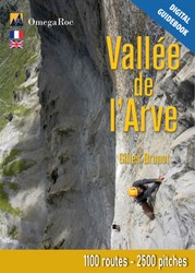
Author(s): Gilles Brunot
Date: 2024
This guidebook is the bible of the Arve Valley. It presents most of the sport crags and multi-pitch routes in the valley, between Cluses and Les Contamines-Montjoie. Predominantly on limestone cliffs (with some gneiss cliffs on the side of Les Contamines) you'll find varied climbing, both in styles and levels.
With 1260 routes spread across 51 sites, there's something for everyone: from single-pitch routes to much taller cliffs, and even some very adventurous sectors (only the most classic routes are detailed here).
The guidebook is produced by Gilles Brunot and the profits generated from the sales of these guidebooks are donated to the EKIPROC association, which funds a significant amount of the equipment used to bolt or re-bolt routes in Haute-Savoie.
The main cliffs in the valley are:
- Sport crags
- Balmette and Superbalmette, Bionnassay, Cascade de Doran, La Duchère, Le Clis, La Frasse, Sous les glaciers
- Multi-pitch sites
- Pointe d’Ayère, Balme, La Croix de Fer, La Maladière, Tête Louis-Philippe, Tours d’Areu, Les Vuardes.
ⓘ

Author(s): Georges Brenas & Gilles Brunot
Date: 2024
This guide is the digital version of the Giffre, Risse, Foron guidebook, with the exception of a few sites that the author has decided not to include due to their limited interest. It includes 900 single-pitch routes and nearly 80 multi-pitch routes spread across 27 sites in the Giffre and Risse valleys north of Cluses, and in the Morzine region.
While most of the cliffs featured are sport crags (between one and three pitches), you will also find some cliffs with bolted multi-pitch routes.
The main cliffs included in this guidebook are: Anthon, Chapelle Saint-Grat, Le Cruz, Le Foron, Le Suet et Le Tuet.
Gilles Brunot and Georges Brenas, the authors of the guidebook, have climbed almost all the routes to provide very detailed information.
The profits generated from the sale of this guidebook are donated to the EKIPROC association, which funds a significant amount of gear for equipping or re-equipping routes in Haute-Savoie.
ⓘ
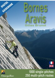
Author(s): Gilles Brunot
Date: 2024
Ce topo numérique regroupe les deux tomes des guides Bornes – Aravis. Seuls quelques sites de moindre intérêt ont volontairement été omis. Il présente les sites compris dans le triangle Cluses – la Roche-sur-Foron – Ugine c’est-à-dire les massifs du Bargy, des Aravis et des Bornes.
Avec 250 grandes voies et 23 falaises sportives (1000 couennes) dont la majorité se trouvent en altitude, Bornes – Aravis est le plus « montagnard » des trois topos de Gilles Brunot. La plupart des sites dominent la vallée, offrant un panorama ouvert exceptionnel.
Les principales falaises de la région sont: Les sites de couennes : La Colombière, Le Maquis, Malsaire, Le Rocher des Aravis, La Forclaz Les sites de grandes voies : La dalle de la Rosière, Le Jallouvre, Rocher de Leschaux, La Mamule , La Paroi de Gramusset, Le Petit Bargy, La Pointe Percée, Pointe Dzérat, Le Sappey
Gilles Brunot, les auteurs du topo, a grimpé quasiment toutes les voies pour fournir des informations très détaillées. Les bénéfices générés par la vente de ce topo sont reversés à l'association EKIPROC qui finance une importante quantité de matériel pour équiper ou rééquiper des voies en Haute-Savoie.
ⓘ
Accommodations nearby more Hide
Share this
Thu 27 Jul
Check out what is happening in La Frasse et Treydon.
Get a detailed insight with a timeline showing
- Ticks by climbers like you
- Discussions of the community
- Updates to the index by our users
- and many more things.
Login to see the timeline!