A Crag Guide gives an extensive view of all sub areas and climbs at a point in the index. It shows a snapshot of the index heirachy, up to 300 climbs (or areas) on a single web page. It shows selected comments climbers have made on a recently submitted ascent.
At a minor crag level this should be suitable for printing and taking with you on a climbing trip as an adjunct to your guidebook.
This guide was generated anonymously. Login to show your logged ascents against each route.
Warning
Rock climbing is extremely dangerous and can result in serious injury or death. Users acting on any information directly or indirectly available from this site do so at their own risk.
This guide is compiled from a community of users and is presented without verification that the information is accurate or complete and is subject to system errors. By using this guide you acknowledge that the material described in this document is extremely dangerous, and that the content may be misleading or wrong. In particular there may be misdescriptions of routes, incorrectly drawn topo lines, incorrect difficulty ratings or incorrect or missing protection ratings. This includes both errors from the content and system errors.
Nobody has checked this particlular guide so you cannot rely on it's accuracy like you would a store bought guide.
You should not depend on any information gleaned from this guide for your personal safety.
You must keep this warning with the guide. For more information refer to our:
Usage policy
Contributors
Thanks to the following people who have contributed to this crag guide:
The size of a person's name reflects their Crag Karma, which is their level of contribution. You can help contribute to your local crag by adding descriptions, photos, topos and more.
Table of contents
- 1. Maw Boulder 1 in Boulder
- 2. Index by grade
1. Maw Boulder 1 route in Boulder
- Summary:
-
All Bouldering
Lat / Long: -27.318640, 152.768618
- Respect the landowners
- Take your rubbish (as always)
- Bring containers for removing public rubbish if you can
- Do not contribute to the graffiti
- Bring poo-bags for your crag pup
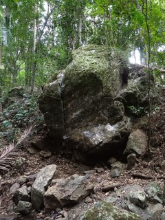
description
Overhanging boulder with a finger crack running up its face
access issues
Rainfall/Flooding/Raised Water Levels
'Cedar Creek' is prone to flash flooding after heavy rainfall and general flooding or regular high water levels during/after rainfall which significantly impacts access to boulders and areas.
Check local community pages if unsure.
Private Property
Toward the end of Cedar Creek Rd are several private properties inaccessible to the public. Ensure no gates are passed (even if open).
approach
15-20 min walk up creek from the Moonchild Area. When the creek splits in 2 take the left creek (going to Greenes Falls). The boulder is on the right, 50m up from the fork.
ethic
'Cedar Creek' has been in the news due to its popularity with the public; namely rubbish and conflicts with landowners. As climbers we must set an example for ourselves:
 |
||||||||
| Route | Grade | Style | Selected ascents | |||||
|---|---|---|---|---|---|---|---|---|
| 1 |
Mamelon Crack
Start with Right hand in crack and left on side pull. Up crack and out, only use the pinch at the top, the crimps on the face are OUT FA: Tim Janetzki, 28 Apr 2021 | V3 | 3m | |||||
2. Index by grade
| Grade | Stars | Name | Style | Pop | |
|---|---|---|---|---|---|
| V3 | Mamelon Crack | 3m |