| Grade | Route | Gear style | Popularity | Crag | |
|---|---|---|---|---|---|
| 4a D II | ★★★ Arete des Cosmiques
Too popular. | 240m | Massif du Mont Blanc | ||
| 3+ | ★★★ Stüdlgrat
https://www.bergsteigen.com/touren/klettern/stuedlgrat-grossglockner/ https://www.youtube.com/watch?v=-Q4iLK8ADbE FA: J. Kerer & P. Groder, 1864 | 550m, 10 | Grossglockner | ||
| 5a | ★★ Edelgrat | 160m, 9 | Solothurner Jura | ||
| 2 | ★★ Normalweg
Der Normalweg auf den Großglockner beginnt beim großen Parkplatz Lucknerhaus bei Kals und führt über die Lucknerhütte zur Stüdlhütte, über das Ködnitzkees zur Erzherzog-Johann-Hütte und von dort auf den Gipfel des Großglockners. Genaue Tourenbeschreibung findet ihr auf Bergsteigen.com. | 1900m | Grossglockner | ||
| {UIAA} 4 | ★★★ Normal Route-West Face
FA: E. Allegra, L, L.Crox, P. Dayne & A. Brocherel, 1900 | 180m | Massif du Mont Blanc | ||
| {UIAA} 3- | ★★★ Hörnligrat
Information: https://www.bergsteigen.com/touren/klettern/matterhorn-hoernligrat/ FA: Peter Taugwalder Jr., Edward Whymper, Peter Taugwalder Sr., Charles Hudson, Lord Francis Douglas & Douglas Robert Hadow, 1865 | 1200m | Matterhorngruppe | ||
| 5 | ★★★ Arête des Papillons
| 250m | Massif du Mont Blanc | ||
| 4b | ★★★ Schildkröten-Grat
1
4a
2
3b
3
2b
4
4a
5
4b
6
3b
7
2b
8
4a
9
3c
10
3b
11
3a
Schöne Gratkleterei die sich als Einsteigertour eignet. Zum Teil sehr exponierte Stellen. Zudem lässt der Fels das Legen von Schlingen, Keilen und Friends zu. Die schwierigste Seillänge an der Klagemauer ist 4b 2p.a. (6c+) und wird meist mit Hilfe der Haken/artificial climbing mit Schlingen (Leiter) bewältigt. Unmittelbar links bietet sich eine leichtere aber exponierte Umgehungsvariante an. Material: 8 Expressschlingen, ein Satz Keile (5-8), 2er Friend, 2-4 120cm Bandschlingen, 2-4 60cm Bandschlingen. (Klar, es kann auch weniger Material mitgenommen und auf das Legen von Zwischensicherungen verzichtet werden). | 280m, 11 | Chli Bielenhorn | ||
| D | ★★★ Chere Couloir
Ice couloir, narrow and up to 80 degrees. Very popular all year round. Belays for rappel down route if you turn around at top of couloir. | 350m | Massif du Mont Blanc | ||
| 6a+ | ★★★ Voie Contamine
1
5c
30m
2
5c
30m
3
5c
30m
4
5c
25m
5
6a+
20m
6
6a+
20m
7
4c
35m
8
4c
15m
9
5b
25m
Best accessed from Aiguille du Midi ca. 1h over glacier. Need to have skills for glacier travel. | 230m, 9 | Massif du Mont Blanc | ||
| PD | ★★ Traverse S-N
Climbing the ridge S to N involves some 4 climbing and 2 rappels along the ridge. Very scenic. Some loose rocks in places. | 150m, 7 | Massif du Mont Blanc | ||
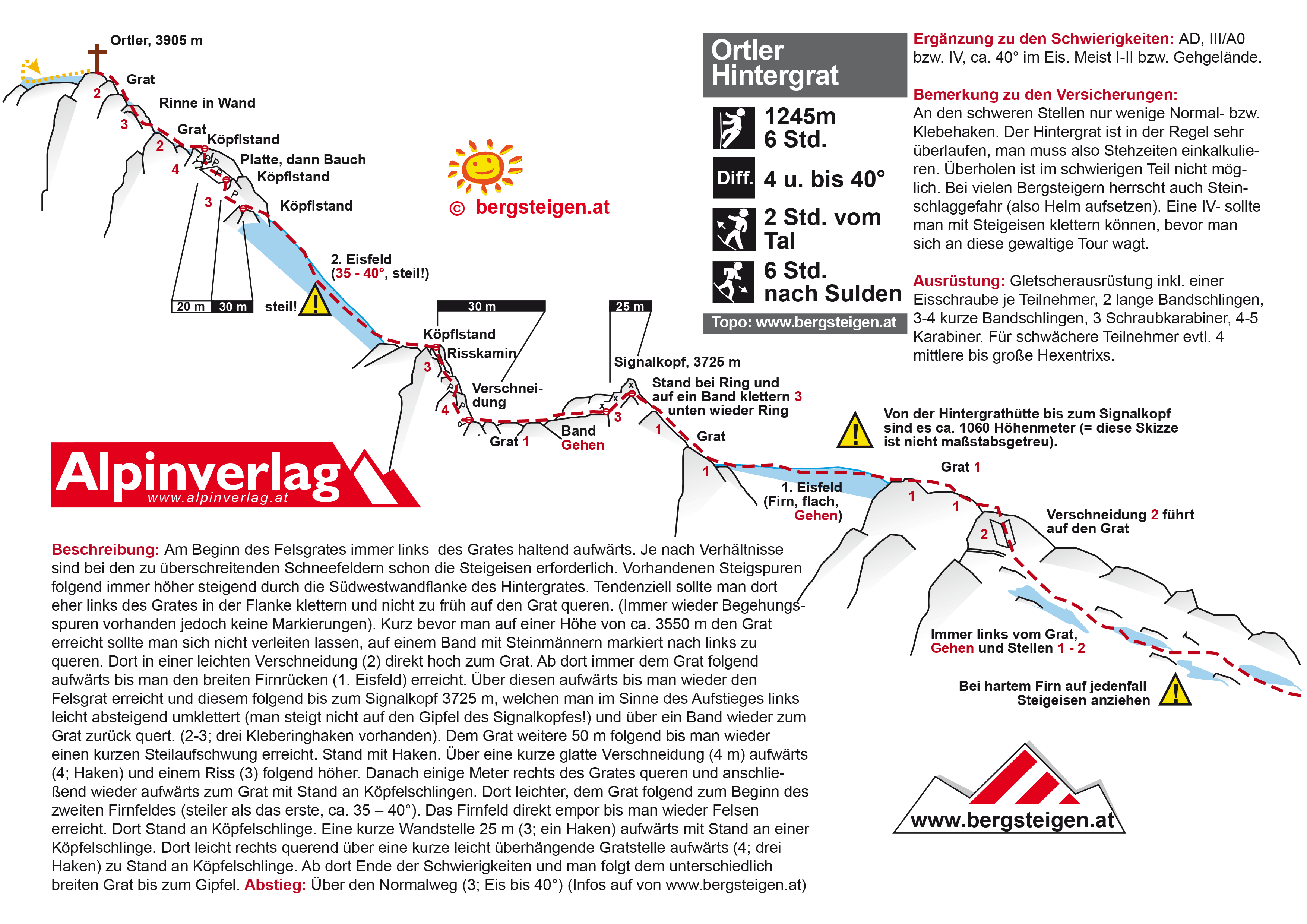
| {UIAA} 4 | ★★ Hintergrat | 900m, 4 | Ortler | ||
| PD | ★★★ SW Ridge
Walk across several kilometers of crevasses on the Geant Glacier to reach Col d'Entrève. Then climb and follow the ridge to the summit. Traverse to the northern summit, then scramble down the northeast ridge. Descend for a while then, angling left reconnect with the traces leading to Col d'Entrèves. Use ice screws to protect a long steep traverse. Turn right to return to Rifugio Torino. | 400m | Massif du Mont Blanc | ||
| 6a D | ★★★ Voie Rebuffat/ Pierre
FA: Bernard Pierre & Gaston Rébuffat, 1956 | 120m, 6 | Massif du Mont Blanc | ||
| F | ★★ SSW Flank | 700m | Monte Rosa Gruppe | ||
| 5c | ★★★ Nabot Léon
FA: Michel Piola & Thierry Cerdan, 1985 | 180m, 5 | Massif du Mont Blanc | ||
| 4+ | ★★ Arête NNE
| 200m | Massif du Mont Blanc | ||
| {UIAA} 4+ | ★★ Alpina | 300m | Gkiona | ||
| PD | ★★ Goûter Route via arete des Bosses
The normal way up Mt Blanc and used in descent for most cases. Normal starting point is Les Houches where you take the cable car and then train to Nid d'Aigle 2372m. There is a couloir below refuge Gouter that is exposed to stonefall, caution. From refuge Gouter 3817m follow rigde to Dome du Goûter then ridge to summit. | 1200m | Massif du Mont Blanc | ||
| 3- | ★★★ Jubiläumsgrat
The Jubiläumsgrat ("Jubilee Ridge") or Jubiläumsweg ("Jubilee Way"), also nicknamed Jubi among mountaineers, is the name given to the climbing route along the ridge between the Zugspitze (2,962 m) and the Hochblassen (2,706 m) (hence it is also called the Blassenkamm which means "Blassen Crest"). In front of its northwestern end, at the wind gap known as Falsche Grießkarscharte, climbers normally cross over to the Alpspitze (2,628 m) or down to the Mathaisenkar. Along the ridge the three peaks of the Höllentalspitzen (2,740 m), the Vollkarspitze (2,630 m) and several rises have to be assailed or circumnavigated. The route is a serious, high Alpine tour and not, as often described, a Via Ferrata. Source Wikipedia FA: Emil Diehl, 1896 FA: Ferdinand Henning, 1897 FA: W. Hofmeier, Karl von Kraus & Karl Wien, 1927 | 8100m | Zugspitze | ||
| 1 - 4 | ★ Promenadengrat
Alpine Mehrseillängentour, Wird auch gerne solo begangen; Begehung nur bei trockenen Verhältnissen ratsam. In der leichtesten Wegführung I - II; kurzeVarianten bis ca. IV möglich. Für den Schwierigkeitsgrad fester Fels. Material: 3 Express, einige Schlingen, Keile u. Friends. Zustieg: Wie zum Glocknergrat, nach ca. 50 m führt ein schmaler Steig nach links auf einen Sattel. Beschreibung bei den Fotos rechts! FA: Unbekannt | 5 | Mödlinger Klause | ||
| 5b | ★★ Brunat-Perroux
| 250m, 7 | Les Aiguilles Rouges | ||
| PD | ★★ WSW Ridge
The normal route. | 1300m | unknown | ||
| {UIAA} 3+ | ★★★ Liongrat
FA: Jean-Antoine Carrel & Jean-Baptiste Bich, 1865 | 640m | Matterhorngruppe | ||
| PD | ★★★ Trois Monts Route
A long and classic way to ascend Mt Blanc. Route is technically easy but a long glacial outing exposed to Serac fall which makes chosing good conditions and timing important. From Col du Midi some 600m up to Mt Blanc du Tacul. Then descending to Col Maudit 4029 and from here som 300m to pass around Mont Maudit and then finally 500m from here to summit. | 1400m | Massif du Mont Blanc | ||
| 3 WI1 | ★★★ Biancograt | 1500m | Bernina Gruppe | ||
| 5+ | ★★ Pilier Cordier / Cordier Pillar
| 660m | Massif du Mont Blanc | ||
| 6b | ★★★ Voie des Suisses
FA: C. Asper, M. Bron, M. Grossi & M. Morel, 1956 | 300m, 11 | Massif du Mont Blanc | ||
| AD | ★★★ Pointe Lachenal Traverse
| 100m | Massif du Mont Blanc | ||
| 7- | ★★ Doktor Ziegenbock
Mainly UIAA 5 FA: N. Fritz, A. Klinger & S. Haag, 2012 | 250m, 6, 3 | Kresperspitze | ||
| 5+ | ★★★ Baderführe
1
5+
35m
2
4+
25m
3
4+
25m
4
5-
30m
5 und 5- (je eine Stelle), Rest 3 bis 4+ | Klemmkeile sinnvoll Easiest route up the "Plattenwand", bolted but bringing some nuts is recommended. FA: Hans Bader, 1930 | 120m, 4 | Wolfebnerspitzen | ||
| 6a | ★★★ Salluard Route
1
4a
30m
2
6a
25m
3
5c
25m
4
5b
25m
5
5c
35m
6
5a
35m
7
5b
30m
8
5c
40m
All the belays are equipped with two bolts. If you climb to top of first tower it is possible to abseil down the route. If you continue the easy pitches to summit you need to abseil / down climb south face (bring approach kit). FA: Toni Busi & Franco Salluard, 1951 | 250m, 8 | Massif du Mont Blanc | ||
| 4c AD | ★★ Arête est (east ridge) - voie normale
| 250m, 9 | Massif du Mont Blanc | ||
| 4 1B | ★★ Valea Gălbinelelor (principal)
| 2 | Coștila | ||
| 5+ | ★★★ Amistad con el Diablo
1
3+
40m
2
3+
30m
3
4
20m
4
5+
25m
5
5
30m
6
5
50m
7
60m
La vía tiene dos pasos clave: la placa del cuarto largo (dos chapas) y el "diedro rompetobillos" del último largo (un clavo). Esta vía es de las mas divertidas y clásicas del Picu Urriellu. Es necesario llevar dos cuerdas ya que en los rapelles las ocuparemos para alcanzar las reuniones (anclajes). Es una vía más mental que física, ya que hay zonas que los posibles seguros alejan bastante. Son 8 largos pero se puede hacer un largo 9 adicional si al llegar a la reunión 8 queremos seguir por el espolón (largo facilillo). | 260m, 6, 6 | Naranjo de Bulnes | ||
| PD | ★★★ Voie normale
From the Gnifetti hut, walk on the Lys glacier and then on the North face of the Pyramide Vincent. | 600m | Monte Rosa Gruppe | ||
| 2 WI1 | ★★★ Spalla-Grat | Bernina Gruppe | |||
| F | ★★ via Breithorn West Summit | 150m | Monte Rosa Gruppe | ||
| {UIAA} IFAS:AD | ★★ SW Ridge | 290m | Monte Rosa Gruppe | ||
| S VI | ★★★ Eagle Ridge | 280m | The Cairngorms | ||
| PD | ★★★ Crochues Traverse
From Rockfax: 6 - 8 hours. One of the most popular routes in the valley. The scrambling is excellent throughout and the rock quality is consistently good until the initial part of the descent, but this is low-angled and brief. Other than the pegs on the first pitch and bolts on the abseil, the route is unequipped so you'll need a rack, albeit a fairly small one. Approach: From the top of the Index chairlift, descend towards Lac Blanc for 50m then take the jeep track on the left which takes you up towards the Grande Floria and Aiguillette de la Floria. Just after the path branches off to the Grande Floria, the jeep track crests a small col and begins to descend rightwards. When it does this, cut off left and pass under the Aiguillette de la Floria and then climb up to the top of the Floria drag lift. 20m past the drag lift take a path off left, across the scree slope and under the foot of Pointe Gaspard before climbing the gully above, on the left initially, following a grassy path. Continue up the path to the col. The final rocky step to the col is up a left-slanting crack which may feel a bit tricky if wet, so you may be glad of a rope on this section. From the col, go east over 50m of easy ground, along a vague ledge system up and rightwards, underneath the Crochues west ridge to reach the foot of the chimney which marks the start of the route - around 1 hour from the chairlift.
Descent: From the north summit, descend to Lac Blanc by scrambling down the Crochues North Ridge for 100m to where the ridge widens out and becomes less solid. Drop off the ridge rightwards and descend a scree/snow slope eastwards towards Lac Blanc. This slope is often snowy well into the summer season but it is the ideal angle for glissading so you can normally get away without crampons. If you leave the crampons behind and realise you need them for the descent, it is possible to carry on along the Crochues north ridge towards the Col du Dards. Shortly before reaching this the ridge drops steeply away and from here, make a 20m abseil east to reach the scree/snow slope where the angle is much lower. Continue down to Lac Blanc and either return to the Index chairlift (45 minutes from Lac Blanc) on an undulating path or descend down to the Flégère cable car (90 minutes). FA: P.le Bec & T.de Lépiney, 1920 | 500m | Les Aiguilles Rouges | ||
| {UIAA} 3 | ★★ Normalweg
FA: M. Innerkofler & G. Ploner, 1879 | 600m | Tre Cime di Lavaredo | ||
| {UIAA} 1 | ★★ WNW Ridge | 590m | Allalinhorn | ||
| 5c | ★★ Voie des Dalles
A classic slab climb with some tricky route finding. A few bolts guiding the way over the slabs, otherwise small cams and nuts. Depending on season you may need crampons and axe for approach & descent. FA: Kintzeler, Mallon & Marutzi, 1967 | 400m, 15 | Les Aiguilles Rouges | ||
| 6a | ★★★ Voie Contamine - Vaucher
A classic varied climb with cracks, corners and chimneys on sound solid rock. FA: André Contamine, Pierre Labrunie & Michel Vaucher, 1957 | 400m, 15 | Massif du Mont Blanc | ||
| 2A | ★★★ Albişoara Gemenelor | Caraiman | |||
| 2A | ★★ Albişoara Crucii | Caraiman | |||
| {UIAA} 7- | ★★ Aioniotita kai mia mera
1
6+
2
4+
3
6-
4
7-
5
6+
6
7-
7
4+
Lots of permanent protection (bolts and wedged nuts) in place. Some additional would be useful but not absolutely necessary if the grade is well within your limit. The original difficulty grades feel significantly lighter and have therefore been adapted here. Loose rock at the end of the 4th and beginning of 5th pitch. More info: http://www.routes.gr/?Page=el/Climbing/Routes/AioniotitaKaiMiaMera | 270m, 7 | unknown | ||
| 1A | Valea Priponului
| Coștila | |||
| III 4 | ★★★ Left Twin | 120m | West Highlands | ||
| 5c D | ★★ Le Lifting du Roi
An excellent route with varied climbing. Rock is mostly excellent, however pitch 3 and 4 have some loose rock. The last pitch is the crux and ended on a small summit. The belays are bolted and there are numerous pitons through out the climb. A standard rack will get you up. FA: M. Datrino & M Spernoe, 2001 | 200m, 10 | Massif du Mont Blanc | ||
| PD | ★★★ SE-ridge
A nice route with spectacular views. The final ridge is very narrow and exposed. The climb starts up the base of the rocky spur descending south from SE ridge follow this until pt. 3885m. From there the ridge becomes narrow with snow and rock. Some small steps with easy climbing leads ton a snow field which lead up to ridge itself around at 4040m. (on the ridge and snow field there are iron bars placed for protection) Follow ridge to summit 4107m. 1,5h FA: Macdonald, Almer & Anderegg, 1863 | 490m | Jungfrau Region | ||
| 4 | ★★★ Nordostgrat
In der Nähe eines kleinen Sees befindet sich der Einstieg. Im ersten Abnschnitt der Tour zum Maningkogel finden sich die klettertechnisch schweren Stellen. Der Gratübergang zum Gipfel des Acherkogels ist leichter, aber ausgesetzter. Der Abstieg über die Nordflanke ist wegen des schuttbedeckten Gesteins anspruchsvoll und mitunter eisig. In der Tour finden sich einige Bohrhaken, zur Absicherung sind einige Friens, Keile und Schlingen sinnvoll. Auf bergsteigen.com findet sich ein Topo. | 570m | Acherkogel | ||
| 1A | Valea Albă | Caraiman | |||
| 6a+ | ★★★ Guy-Anne l'insolite
1
5c
20m
2
5c
30m
3
6a+
35m
4
6a+
40m
5
5c
35m
6
6a
30m
7
6a
35m
8
6a
40m
9
5c
35m
10
6a
30m
11
6a
30m
12
6a
35m
| 400m, 12, 14 | Massif du Mont Blanc | ||
| 5b | ★ Esperó Doppelmayer
1
4c
2
5b
3
5b
| 100m, 3 | Arcalís | ||
| PD | ★★ NW Flank and upper SW Ridge
The normal route. | 1100m | unknown | ||
| 3a PD | ★★★ Via Normale - South Face
This is the Hiker's route on the south face and the typical way to descent from the summit. The start of the route begins at the "Andreotti" bivouac, a hut used only for emergency. This hut can be approached from either Varaita Valley or Quintino Sella Hut, over the Sagnettes Pass. The best time to attempt this climb is between early August and mid September, where ice and snow have disappeared and the rock is stabilized. In this period crampons and ice gear are generally not necessary but parties usually start the route roped and wearing helmets. The route is signed by yellow marks and it takes normally 3 hours from the emergency hut to reach the cross on the summit. FA: William Mathews, Frederick Jacomb, Jean-Baptiste Croz & Michel Croz, 1861 | 600m | Monviso | ||
| 4b | ★★★ Gratüberschreitung
1
3a
2
3b
3
3a
4
4a
5
3a
6
2b
7
3b
8
2a
9
4b
10
3a
| 10 | Dri Horlini | ||
| D | ★★★ Arête Kuffner
FA: Alexandre Burgener, Josef Furrer & Moritz von Kuffner, 1887 | 900m | Massif du Mont Blanc | ||
| 7- | ★★ Hirschbrunft | 110m, 4 | Hochwiesler | ||
| 4b | ★★★ Ostgipfel Nordpfeiler
Eine sehr schöne Kletterei in solidem Fels, welche zusammen mit dem Gletscher Zu-und Abstieg eine komplette Hochtour mit allen Facetten ergibt. Es sind einzelne Bohrhaken in der Route, gerade an der schwierigen Schlüsselstelle, welche auch links umgangen werden kann. Nach der Kletterei gelangt man über den Firngrat auf den Palü Ostgipfel. Falls keine Spur vorhanden ist erfordert der Zu- und Abstieg gute Fähigkeiten in der Wegfindung durch die Gletscherspalten. Zustieg: Auf der Palü Normalroute bis auf ca 3280 m.ü.M. und von dort nach rechts an den Einstieg auf ca. 3320 m.ü.M. queren. Abstieg: Der kürzeste Abstieg führt über den Normalweg runter zur Diavolezza. Minimales Material für Kletterei: Seil 30m, 3 Friends 0.5-1(BD), 3 Keile, 4 Expressen, 2 Zackenschlingen. Zudem übliche Hochtourenausrüstung. | 400m | Bernina Gruppe | ||
| PD | ★★ SE-ridge
easy mixed snow rock ridge climb. Crampons and ice axe | 250m | Massif du Mont Blanc | ||
| {UIAA} 3+ | ★★ Hauptgipfel - Normalweg
Climbing mainly "on the short rope" with some pitches at the steepest places. Duration: 4-5 hours. Equipment: trad + crampons, if selecting the ice chute. | 1500m | Sassolungo | ||
| 5c TD | ★★★ Pilier Gervasutti
FA: P. Formelli & G. Mauro, 1951 | 850m | Massif du Mont Blanc | ||
| 3 | ★★★ Stadlwandgrat
1
3-
45m
2
2+
20m
3
1
30m
4
3-
30m
5
2
15m
6
2+
35m
7
3
40m
8
3-
45m
9
1+
35m
10
2
25m
11
1+
30m
12
2+
35m
| 390m, 12 | Höllental | ||
| 4 | ★★★ Gamsgartlgrat
1
3
30m
2
4-
25m
3
4-
25m
4
1
50m
5
3
25m
6
2
40m
7
3+
20m
8
4-
25m
9
4
40m
10
2
100m
11
4
40m
FA: B.Engau, F.Siebenheitl & S.Steiner, 1931 | 420m, 11, 5 | Schneeberg | ||
| PD | ★★★ via Col du Midi and Mt Maudit
| 1200m | Massif du Mont Blanc | ||
| {FR} D | ★★ S-face (Siluetten) route
A classic climb in the area. Takes the siloutte as seen from Kebnekaise mountain hut. | 500m | Kebnekaise massif | ||
| ★★ La Normal
Einfachster Aufstieg ohne Seilbahnbenutzung | 1400m | Tenerife | |||
| {UIAA} 5 | ★★★ Verso nuove stagioni | 200m, 4 | Lazio | ||
| 6b+ V | Intxusmis | 20m | Arboli | ||
| 6b+ | ★★ Fragel Rock | 270m, 7 | Montserrat | ||
| 1A | Brâul Mare al Jepilor | Jepii Mici | |||
| 4 2B | ★★★ Olperer Nordgrat | 350m, 6 | Valsertal | ||
| D | ★★★ N-face
Classic initiation to larger ice climbs. Up to 50 degrees ice. | 330m, 7 | Massif du Mont Blanc | ||
| PD D VF_NUM:3 | ★★ Via Normale
Starts at Rifugio Pian dei Fiacconi, crosses a small glacier to Forcella de la Marmolada, then follows the Marmolada Cresta Ovest (Marmolada West Ridge) via ferrata from to the Punta Penia summit. | 700m | Marmolada | ||
| 6b | ★★★ Majorette Thatcher
FA: Michel Piola & Pierre-Alain Steiner, 1984 | 180m | Massif du Mont Blanc | ||
| II | ★★ Right Twin | 120m | West Highlands | ||
| 4b | ★★★ Класика
1
4b
2
4b
3
4b
Перша мотузка: по діагоналі до полички на якій вільно розміщаються 3-5 людей. Друга мотузка: 10-15 метровий траверс. Третя мотузка: вертикальний підйом до ще більш зручної полички\станції. Дюльфер з верхньої станції відразу до низу лише при наявності двох мотузок, або у вас 100м | 40m, 3, 6 | Dovbush Rocks | ||
| 5+ | ★★ Pavlín - Kračalík
| Mengusovská dolina | |||
| 1 | ★★★ Normal
Some exposed scrambling and hiking to the highest peak of greece. | Olympus | |||
| {FR} 4b | ★★ Südschluchtkante
1
4a
35m
2
4b
40m
| 75m, 2 | Höllengebirge | ||
| 4c AD | ★★ Table du Roc spur
| 440m | Massif du Mont Blanc | ||
| {UIAA} 3+ | ★★★ Normalweg
The normal route via Payer Hut. Short 3+ section, lots of scrambling, Ice up to 40° | 880m | Ortler | ||
| 7 | ★★★ Little Norway
Mainly UIAA 6/6+, eine Stelle 7 / 6+ A0. Sehr lohnende Route, der Einstieg befindet sich 2m links der Doktor Ziegenbock! | 250m, 7 | Kresperspitze | ||
| 6+ | ★★★ Han-Ton
| Totalphütte | |||
| ED | ★★★ North face / Walker spur
Long alpine climb mainly on rock. Crux, 75m dihedral 5+ FA: R. Cassin, B. Esposito & U. Tizzioni, 1938 | 1200m | Massif du Mont Blanc | ||
| 4+ | Bluatschink | 350m, 10 | Wolfebnerspitzen | ||
| {UIAA} 6 A0 | ★★★ DIEDRO DEGLI ELFI
1
6 A0
40m
2
5
20m
3
5+
35m
4
3
30m
5
6- A0
35m
6
3
25m
TURAN | 190m, 6 | Turan - GEM85 e Preabocco | ||
| D | ★★★ NW-spur, Nollen-route
A long alpine climb with one ice crux (Nollen) half way up. Crux is 2-3 pitches ice climbing of around 50 degrees with shorter passge of 60-70 depending on conditions. After passing Nollen retreat is difficult. Start from Guggi hut 2791m which is reached by hiking from Eiger gletscher train station. Descent via SE-ridge. FA: von Fellenberg, Michel & Egger, 1866 | 1300m | Jungfrau Region | ||
| PD | ★★★ Crossing North-East/West
From the Gnifetti hut, walk on the Lys glacier toward the Lysjoch pass. Then join the North-East face of Parrotspitze. Descend by the West face. | 810m | Monte Rosa Gruppe | ||
| PD | ★★★ From Parrotspitze
After descending from the West face of Parrotspitze, climb the North-East face of Ludwigshohe. Descend to the Lys pass by the North-West face. | 20m | Monte Rosa Gruppe | ||
| 6b+ | ★★★ Bonatti - Tabou combination
Combination of the Old Bonnati route first 4 pitches and the last 2 pitches of Tabou makes for a good 5c to 6b+ climb. This avoids the harder pitches of the other routes. | 200m, 6 | Massif du Mont Blanc | ||
| 5a | ★★ Modern Times
A nice bolted climb with great views. Start altitude: 2,225m Approach: From the top of the Index chairlift, head slightly left towards the buttress. The route is on the wall facing you. Enter the route from the right of the buttress, up where the terrain gets noticeably more vertical.
Descent: Scramble down a route off the back of the buttress towards a loose gully between you and l’Index. Scramble generally leftwards down the gully towards an equipped 28m abseil. At the foot of the abseil walk directly back to the chairlift. FA: R.Grindley, E.Grindley & M.Johnson, 2007 | 190m, 6 | Les Aiguilles Rouges | ||
| PD | ★★ Arête à Laurence
| 100m | Massif du Mont Blanc | ||
| 6b | ★★★ L'Eau Rance D'Arabie
FA: Michel Piola & Pierre-Alain Steiner, 1985 | 250m | Massif du Mont Blanc | ||
| PD | ★ North-West Face (Tacul)
Normal route on Mt Blanc du Tacul. The NW-face may some years have hanging glaciers that are difficult to cross. Also the first part of the "3 montes route" to ascend Mt Blanc. | 700m | Massif du Mont Blanc | ||
| 2 | ★ Wilderersteig + Var. Gustl
Leichter Anstieg mit viel Gehgelände, öfters Solo begangen. Einige Schlingen f. Bäume mitnehmen! Die Variante 4a "Gustl III+" in der zweiten SL führt nach der Verschneidung über einen festen, kurzen Grat. Danach ( 2 Baumschlingen ) mit einer lustigen Hangelquerung nach Li. zur Org. - Route. | 60m, 2, 8 | Friedrichswand | ||
| ★ Ordinary Route | 480m | Jegihorn |
")