A Crag Guide gives an extensive view of all sub areas and climbs at a point in the index. It shows a snapshot of the index heirachy, up to 300 climbs (or areas) on a single web page. It shows selected comments climbers have made on a recently submitted ascent.
At a minor crag level this should be suitable for printing and taking with you on a climbing trip as an adjunct to your guidebook.
This guide was generated anonymously. Login to show your logged ascents against each route.
Warning
Rock climbing is extremely dangerous and can result in serious injury or death. Users acting on any information directly or indirectly available from this site do so at their own risk.
This guide is compiled from a community of users and is presented without verification that the information is accurate or complete and is subject to system errors. By using this guide you acknowledge that the material described in this document is extremely dangerous, and that the content may be misleading or wrong. In particular there may be misdescriptions of routes, incorrectly drawn topo lines, incorrect difficulty ratings or incorrect or missing protection ratings. This includes both errors from the content and system errors.
Nobody has checked this particlular guide so you cannot rely on it's accuracy like you would a store bought guide.
You should not depend on any information gleaned from this guide for your personal safety.
You must keep this warning with the guide. For more information refer to our:
Usage policy
Contributors
Thanks to the following people who have contributed to this crag guide:
The size of a person's name reflects their Crag Karma, which is their level of contribution. You can help contribute to your local crag by adding descriptions, photos, topos and more.
Some content has been provided under license from: © Matt Battani (Matt Battani)
Table of contents
- 1. Kilibi / Shard 2 in Area
- 2. Index by grade
1. Kilibi
- Summary:
-
All Trad climbing
Lat / Long: 3.112686, 33.412518
summary
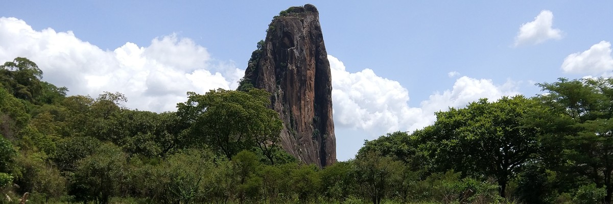
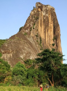
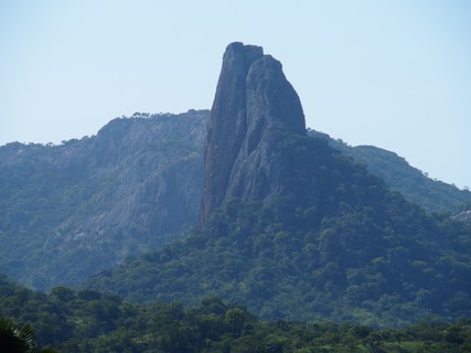
This shard looking tower is one of the most impressive and intimidating rocks you'll see anywhere in Uganda. There are two known routes to the top and potential for more.
description
Near the village of Akwang in the Paimol sub-area of Agago District, there is great climbing potential. We only climbed Kilibi Rock. (see Deep in the Village and Normal Route) A drive around the area to/from Kalongo will yield other impressive rocks and possible climbs. Mt. Kokil is next to Kilibi and looks hikeable. There may be a number of quality lines there and in the adjacent rocks . This area is very near the climbs of Amiel and Mt. Oret. About an hour’s drive will get you to Rwot and Loyoroit.
The map shows the Kilibi inside the shape in the west. The shape in the east shows the parking and the line on the map links the parking and the rock showing the approximate hike in.
access issues
Free and unrestricted. This area sees very little interaction with the outside world. It is like going back in time! People are very friendly. They ask for money. We usually give a small give gift like a bag of salt or rice.
approach
Drive through Paimol and then through Akwang. Just a couple hundred meters after Akwang, there is a easily missed left turn just before a bridge. You’ll need a 4WD because this turn goes down into a ditch and up to a very poor road. Follow that road as far as you can past the huts, trending to the right to Joseph’s house (3.11523, 33.42742). You’ll be about 200m off the main Akwang road when you park. You’ll be unable to see Kilibi from here, but tell locals you want Kilibi and they will all point you in the right direction. A couple hundred meters past the parking at Joseph’s you’ll see Kilibi.
If unsure, you can ask around for Joseph and should ask permission to park there. He's a very nice/friendly guy.
If you don't have a strong car, or prefer a better road, you could also park at Akwang on the main road and walk in. The hike from Joseph's is about 40 mins. Locals can show you the way or follow your gps or the map.
where to stay
This is easily reachable from guest houses in Kalongo.
ethic
Nobody lives at the foot of this rock, so nobody is likely to ask money for climbing it. Locals live a few hundred meters away. This also means that trails run out a bit near Kilibi. Some bushwhacking is necessary to reach the rock itself in rainy season, however the approach is less bushy than Amiel and Mt. Oret. Please be friendly and kind to the local people. They have let us climb in the past but as this is their community, please play by their rules.
history
I first saw this rock in 2016 and hunted around for the best approach. We returned and climbed two routes on Kilibi in 2017. Deep in the Village has only been climbed once. There is no mentioned of this rock in either the 1962/63 guidebook or the 1991 guidebook. It is also not mentioned on any other climbing websites.
   |
||||||||
| Route | Grade | Style | Selected ascents | |||||
|---|---|---|---|---|---|---|---|---|
| 1 |
★★★ Deep in the Village
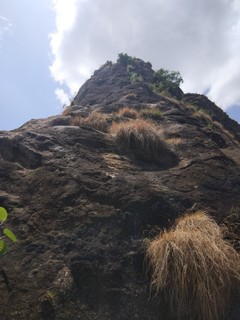
Deep in the village 20 (Descrition by M Battani and U Pitsch) (approximately N3.11206° E33.40837°) Get up early for this one as it is a full day with the drive from Kalongo, parking, hiking, rapping, and getting home. We left our guest house in Kalongo at 6:15am. You may want to carry your boots/shoes on the climb because the descent is on the opposite side of the climb. We hiked barefoot back to our gear at the base of the first pitch. It hurt. The route starts on the north east side of Kilibi Rock. You can see a big ramp leading up Kilibi. The first pitch starts up this ramp. Aim for the large flake about 60m up for your first stance.
FFA: Matt Battani, U Pitsch & W Rutowski, 23 Jun 2017 | 20 PROT:X | 280m, 6 | |||||
| 2 |
★ Normal Route
Description by Uwe Pitsch The route starts on the west side of Kilibi Rock.
FFA: Uwe Pitsch, 22 Jun 2017 | 14 | 120m, 3 | |||||
2. Index by grade
| Grade | Stars | Name | Style | Pop | |
|---|---|---|---|---|---|
| 14 | ★ | Normal Route | 120m, 3 | ||
| 20 X | ★★★ | Deep in the Village | 280m, 6 |