A Crag Guide gives an extensive view of all sub areas and climbs at a point in the index. It shows a snapshot of the index heirachy, up to 300 climbs (or areas) on a single web page. It shows selected comments climbers have made on a recently submitted ascent.
At a minor crag level this should be suitable for printing and taking with you on a climbing trip as an adjunct to your guidebook.
This guide was generated anonymously. Login to show your logged ascents against each route.
Warning
Rock climbing is extremely dangerous and can result in serious injury or death. Users acting on any information directly or indirectly available from this site do so at their own risk.
This guide is compiled from a community of users and is presented without verification that the information is accurate or complete and is subject to system errors. By using this guide you acknowledge that the material described in this document is extremely dangerous, and that the content may be misleading or wrong. In particular there may be misdescriptions of routes, incorrectly drawn topo lines, incorrect difficulty ratings or incorrect or missing protection ratings. This includes both errors from the content and system errors.
Nobody has checked this particlular guide so you cannot rely on it's accuracy like you would a store bought guide.
You should not depend on any information gleaned from this guide for your personal safety.
You must keep this warning with the guide. For more information refer to our:
Usage policy
Contributors
Thanks to the following people who have contributed to this crag guide:
Aayush Tripathi
Kai
Thomas Huber
The size of a person's name reflects their Crag Karma, which is their level of contribution. You can help contribute to your local crag by adding descriptions, photos, topos and more.
Table of contents
- 1.
Garhwal Himalaya
12 in Area
- 1.1. Satopanth 1 in Cliff
-
1.2.
Maldevta Rock Climbing Area 8 in Area
- 1.2.1. Maldevta Intermediate Crag 8 in Crag
- 1.2.2. Maldevta Beginner Crag 0 in Crag
-
1.3.
Gangotri Group 3 in Area
- 1.3.1. Mt. Shivling 3 in Crag
- 2. Index by grade
1. Garhwal Himalaya 12 routes in Area
- Summary:
-
Sport climbing and Alpine climbing
Lat / Long: 30.371008, 78.757876
summary
Home to the Gangotri National Park which covers 2390 square km and home to some of the most iconic and distinct peaks such as Shivling, Meru, Bhagirathi, Thalay Sagar, etc.
description
The Garhwal Himalayas are mountain ranges located in the state of Uttrakhand, India.
access issues
The road to Gangotri can be blocked by landslides and floods.
approach
Access to Gangotri National Park is via the holy town of Gangotri. If approaching from Delhi, take an overnight train from Delhi to Dehradun and then travel by road to Gangotri (3415m) via Musoori (2005m). Most people choose to overnight in Musoori and then continue to Gangotri the next day. The road ends at Gangotri after which access to all the peaks in the Gangotri National Park are via foot.
where to stay
Gangotri (3415m)
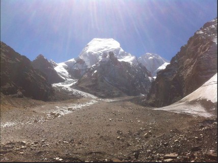
1.1. Satopanth 1 route in Cliff
- Summary:
-
All Alpine climbing
Lat / Long: 30.846746, 79.210272
description
Mount Satopanth (7075m) is one of the most prominent peaks of the Garhwal of Himalayas and the second highest peak in Gangotri National Park.
approach
Gangotri -> Chirbasa -> Bhojbasa -> Nandanvan -> Vasuki Tal (BC) -> ABC (optional) -> C1 -> C2 -> C3 (optional) -> Summit
history
First climbed along the northeast ridge by a Swiss party in 1947 consisting of André Roch, René Ditterit, Alexander Graven and Alfred Sutter
 |
||||||||
| Route | Grade | Style | Selected ascents | |||||
|---|---|---|---|---|---|---|---|---|
| 1 |
★★ Northeast Ridge
The standard ascent route on Satopanth follows the Northeast ridge which was the same route climbed by the first ascent. The route consists of glacier travel to the base of the peak and then climbing over a rock face (which, depending on the time of year could be mixed ice and snow) to get onto the lower slopes of the peak. The route includes a knife ridge between 6100m and 6500m consisting of exposure at both sides. FA: André Roch, René Ditterit, Alexander Graven & Alfred Sutter, 1947 | {FR} AD | 2200m | |||||
1.2. Maldevta Rock Climbing Area 8 routes in Area
- Summary:
-
All Sport climbing
Lat / Long: 30.380507, 78.160457
summary
Maldevta Rock Climbing Area- Two crags have been developed near Maldeveta, Dehradun for sport climbing. The crags are right next to the Song river having river-washed Shale rock.
description
The routes are well protected with bolts and anchors having chains/crane-hooks/rings. A 50-meter rope is sufficient. Don't forget your helmet as sheep and monkeys frequent the trails above the crag. You don't need any permission to climb in this area. The summer season does attract Dehradun locals to the riverside where they drink, cook and party. If they choose to party around the rocks then you can request them to move a little away.
access issues
The summer season does attract Dehradun locals to the riverside where they drink, cook and party. If they choose to party around the rocks then you can request them to move a little away.
Season: All months of the year except Monsoon months ie. July, August, and September. Don't try your luck on rainy days, as the chances of rockfall Post-monsoon crossing the river is challenging, so be careful.
approach
How to reach The climbing area is about 15 km from the Dehradun city centre. lIt's best to have a private vehicle to reach the crag. The Maldevta Temple Reniwala They still conduct their training on weekdays at the is your first landmark, which is 5 km away from the crags. Drive straight from the temple keeping the river on the right and do not cross any bridge. The 'GoStops' hostel which is 1.5 km before the climbing area is a good landmark. Once you reach the crag, cross the river by jumping across boulders. Location Coordinates: 30.378680, 78.159411
where to stay
Pitching a tent on top of the intermediate area is nice. 'GoStops' hostel which is 1.5 km before the climbing area is a good landmark
history
BSF- Indian armed forces called Border Security Force had first explored these faces and marked them in 2013. They still conduct their training on weekdays at the beginner climbing location. However, they don't use the intermediate area so much. They are very much okay with climbers climbing the rock they have marked.
Early exploration were made by Nitesh, Loki and Shekhar by top roping some of the routes on trad anchors. Yash with the help of Himanshu is responsible for bolting and cleaning up most routes in this area. Special thanks to Tony Da for initiating the development, he bolted the routes-1, 2, and 3. And Mohit Oberoi for his guidance and hardware support.
1.2.1. Maldevta Intermediate Crag 8 routes in Crag
- Summary:
-
Lat / Long: 30.378676, 78.159465
summary
Maldevta Intermediate Crag
description
The crag is next to the Song river having river-washed Shale rock. It has a mix of overhang and vertical climbing with huge jugs and sloper holds, along with some crack climbing in the mix.
approach
How to reach The climbing area is about 15 km from the Dehradun city centre. lIt's best to have a private vehicle to reach the crag. The Maldevta Temple. Drive straight from the temple keeping the river on the right and do not cross any bridge. The 'GoStops' hostel which is 1.5 km before the climbing area is a good landmark. Once you reach the crag, cross the river by jumping across boulders.
| Route | Grade | Style | Selected ascents | |||
|---|---|---|---|---|---|---|
| 1 | Pragati | {FR} 5c+ | 12m, 4 | |||
| 2 | Naram-Garam | {FR} 5b | 16m, 5 | |||
| 3 | Punarjanma | {FR} 6c | 18m, 8 | |||
| 4 | ★★ Punya-Paap | {FR} 6b | 17m, 5 | |||
| 5 | Krantiveer | {FR} 6b+ | 23m, 11 | |||
| 6 | ★★ Shilajit | {FR} 6a+ | 10m, 3 | |||
| 7 | YYY | {FR} 7a | 12m, 5 | |||
| 8 | XXX | {FR} 7a+ | 12m, 5 | |||
1.2.2. Maldevta Beginner Crag 0 routes in Crag
summary
Maldevta Beginner Crag
1.3. Gangotri Group 3 routes in Area
- Summary:
-
All Alpine climbing
Lat / Long: 30.817456, 79.150645
description
The Gangotri Group of mountains is a subdivision of the Garhwal Himalaya in the northern Indian state of Uttarakhand. It rings the Gangotri Glacier, and contains peaks that are notable either for their religious significance to Hindus, for their difficult climbing routes, or both. Climbs on three of the peaks (Thalay Sagar, Shivling, and Meru) have resulted in the awarding of the prestigious (but controversial) climbing award, the Piolet d'Or. Source Wikipedia
1.3.1. Mt. Shivling 3 routes in Crag
- Summary:
-
Lat / Long: 30.881583, 79.066486
description
Shivling is a mountain at tapovan in the Gangotri Group of peaks in the western Garhwal Himalaya, near the snout of the Gangotri Glacier, one of the biggest glaciers in the Himalayas, and Tapovan, a beautiful lush meadows, both being also popular pilgrimage sites in Hinduism. It lies in the northern Indian state of Uttarakhand, 6 kilometres (4 mi) south of the Hindu holy site of Gaumukh (the source of the Bhagirathi River). Its name refers to its status as a sacred symbol -Shiva Linga. It was called "Matterhorn Peak" by early European visitors because of its similarity in appearance to that Alpine peak. While not of locally great elevation, it is a dramatic rock peak, and the most visually striking peak as seen from Gaumukh; that and the difficulty of the climb make it a famed prize for mountaineers. Source Wikipedia
| Route | Grade | Style | Selected ascents | |||
|---|---|---|---|---|---|---|
| 1 |
West Ridge
The ridge is the lowest-angle feature on the mountain, but still involves serious mixed climbing, and is threatened by the serac barrier noted by the Germans. The ridge leads to the col between the two summits; a steep snow/ice ridge then leads to the main summit. Source Wikipedia FA: Hukam Singh & Indo-Tibetan Border Police, 1974 | |||||
| 2 |
North Pillar
FA: Hans Kammerlander & Christoph Hainz, 1993 | |||||
| 3 |
★★★ Shiva´s Line
Direct finish to the 'North Ridge', a line climbed in part by the Japanese in 1980 and by Hans Kammerlander and Christophe Hainz in 1993. FA: Thomas Huber & Iwan Wolf, 2000 | {UIAA} 7 A4 MIXED:M6 | 1400m | |||
2. Index by grade
| Grade | Stars | Name | Style | Pop | Area | |
|---|---|---|---|---|---|---|
| 5b | Naram-Garam | 16m, 5 | 1.2.1. Maldevta Intermediate Crag | |||
| 5c+ | Pragati | 12m, 4 | 1.2.1. Maldevta Intermediate Crag | |||
| 6a+ | ★★ | Shilajit | 10m, 3 | 1.2.1. Maldevta Intermediate Crag | ||
| 6b | ★★ | Punya-Paap | 17m, 5 | 1.2.1. Maldevta Intermediate Crag | ||
| 6b+ | Krantiveer | 23m, 11 | 1.2.1. Maldevta Intermediate Crag | |||
| 7 A4 M6 | ★★★ | Shiva´s Line | 1400m | 1.3.1. Mt. Shivling | ||
| 6c | Punarjanma | 18m, 8 | 1.2.1. Maldevta Intermediate Crag | |||
| 7a | YYY | 12m, 5 | 1.2.1. Maldevta Intermediate Crag | |||
| 7a+ | XXX | 12m, 5 | 1.2.1. Maldevta Intermediate Crag | |||
| ? | North Pillar | 1.3.1. Mt. Shivling | ||||
| West Ridge | 1.3.1. Mt. Shivling | |||||
| AD | ★★ | Northeast Ridge | 2200m | 1.1. Satopanth |