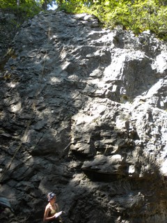
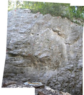
A Crag Guide gives an extensive view of all sub areas and climbs at a point in the index. It shows a snapshot of the index heirachy, up to 300 climbs (or areas) on a single web page. It shows selected comments climbers have made on a recently submitted ascent.
At a minor crag level this should be suitable for printing and taking with you on a climbing trip as an adjunct to your guidebook.
This guide was generated anonymously. Login to show your logged ascents against each route.
Warning
Rock climbing is extremely dangerous and can result in serious injury or death. Users acting on any information directly or indirectly available from this site do so at their own risk.
This guide is compiled from a community of users and is presented without verification that the information is accurate or complete and is subject to system errors. By using this guide you acknowledge that the material described in this document is extremely dangerous, and that the content may be misleading or wrong. In particular there may be misdescriptions of routes, incorrectly drawn topo lines, incorrect difficulty ratings or incorrect or missing protection ratings. This includes both errors from the content and system errors.
Nobody has checked this particlular guide so you cannot rely on it's accuracy like you would a store bought guide.
You should not depend on any information gleaned from this guide for your personal safety.
You must keep this warning with the guide. For more information refer to our:
Usage policy
Contributors
Thanks to the following people who have contributed to this crag guide:
Adam Pullen †
Melwin Quacke
Victor
Samuel Troxler
Hubert Virtos
Stefan
Nicolas Descloux
mike
Marcel Czink
Tina
The size of a person's name reflects their Crag Karma, which is their level of contribution. You can help contribute to your local crag by adding descriptions, photos, topos and more.
Table of contents
- 1. Linker Burggraben 18 in Sector
- 2. Index by grade
1. Linker Burggraben 18 routes in Sector
- Summary:
-
All Sport climbing
Lat / Long: 47.103646, 9.490229
access issues
Public car-park, paved foot path, easy walk from top of crag to climbing routes.
ethic
As your walking from the public car-park to the hiking trail you may see cars parked along the road. Please do not get tempted to park here, you will only save your self 4 mins of walking but will start to upset the locals.
  |
||||||||
| Route | Grade | Style | Selected ascents | |||||
|---|---|---|---|---|---|---|---|---|
| 1 | Plättli | 4c | 20m | |||||
| 2 | ★ Sandührli | 4c | 20m | |||||
| 3 | ★ Claudia M. | 4c | 20m | |||||
| 4 | Selva | 5c+ | 20m | |||||
| 5 | ★ Buuch | 6a | 20m | |||||
| 6 | ★★ Eggli | 5c+ | 20m | |||||
| 7 | ★ Stiigwax | 4c | 20m | |||||
| 8 | Burgkater | 4b | 20m | |||||
| 9 | Grisu | 4c | 20m | |||||
| 10 | ★ Füürwehrleitera | 4c | 20m | |||||
| 11 | Das goht ja nööd! | 4b | 20m | |||||
| 12 | Zaubertränkli | 6a | 20m | |||||
| 13 | Römerschreck | 6a+ | 20m | |||||
| 14 | Obelix | 4a | 20m | |||||
| 15 | Dagoberts $ | 4c | 20m | |||||
| 16 | ★ Lotti Kneift | 5b | 20m | |||||
| 17 | ★ Beim Teutates | 6a+ | 20m | |||||
| 18 | Wissä Sunntig | 5c+ | 20m | |||||
2. Index by grade
| Grade | Stars | Name | Style | Pop | |
|---|---|---|---|---|---|
| 4a | Obelix | 20m | |||
| 4b | Burgkater | 20m | |||
| Das goht ja nööd! | 20m | ||||
| 4c | ★ | Claudia M. | 20m | ||
| Dagoberts $ | 20m | ||||
| ★ | Füürwehrleitera | 20m | |||
| Grisu | 20m | ||||
| Plättli | 20m | ||||
| ★ | Sandührli | 20m | |||
| ★ | Stiigwax | 20m | |||
| 5b | ★ | Lotti Kneift | 20m | ||
| 5c+ | ★★ | Eggli | 20m | ||
| Selva | 20m | ||||
| Wissä Sunntig | 20m | ||||
| 6a | ★ | Buuch | 20m | ||
| Zaubertränkli | 20m | ||||
| 6a+ | ★ | Beim Teutates | 20m | ||
| Römerschreck | 20m |