Grado 4 mayormente más fácil. Probablemente ascensos prehistóricos. Todos los aseguramientos se atornillaron. 2,5-3 horas. Memoriza la ruta, ¡también es la ruta del rappel!
Aproximación: Desde el aparcamiento de la carretera (memorial de los damnificados del incendio forestal de 1986) avanzar 200m por la carretera en dirección San Sebastián hasta un punto de interrupción a la derecha en el terraplén. Desde allí, continúe por un camino estrecho a través de un bosque de matorrales hasta las escaleras estrechas hechas por el hombre visibles desde la calle y abruptamente sobre esta hasta una plataforma artificial (depósito de mochilas, punto de conexión para escalar).
Ruta: Desde la carretera sobre la cresta hasta la escalera artificial visible desde la carretera. Cruza la escalera hasta una repisa y avanza hacia la esquina grande. Esta esquina (cerrojo), al final a la izquierda para hacer rappel. Pared inclinada, esquina y pared fácil de anular. Muro de losa izquierda a repisa (anillo). Cruce a la izquierda y en la esquina grande sobre las repisas para dar la vuelta y de izquierda a la esquina. Esto y al final hacia la derecha hasta la cima. (Traducción de la descripción de la ruta en alemán)
Libro de la cumbre: desde la cumbre, baja en dirección al monumento al fuego del bosque, el libro está escondido en un cantero.
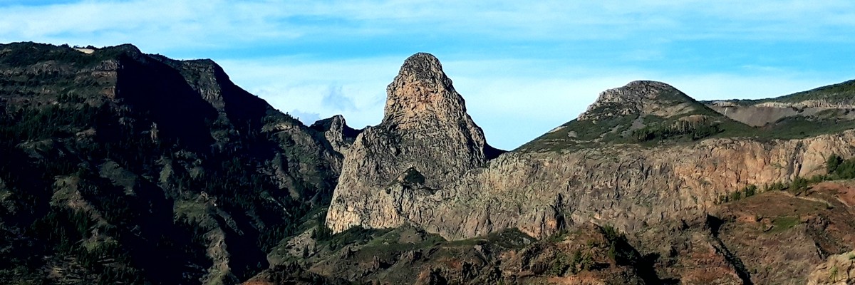
 Grade 4 mostly easier. Probably prehistoric ascents. All belays bolted. 2.5-3 hours. Memorize the route, it is also the abseil route!
Approach: From the parking on the road (memorial for the victims of the forest fire of 1986) go 200m on the road in the direction of San Sebastián to an interruption point on the right at the embankment. From there continue on a narrow path through bush forest to the narrow, man-made stairs visible from the street and steeply over this to an artificial platform (rucksack depot, attachment point for climbing).
Route: From the road over the ridge to the artificial staircase visible from the road. Cross the staircase to a ledge and traverse right upwards to the big corner. This corner (bolt), at the end left to abseil bolt. Leaning wall, corner and easy wall to ring. Left slabby wall to ledge (ring). Traverse left and in big corner over ledges to ring and left to corner. This and at the end rightwards to the top. (Translation from german route description)
Summit book: From the summit climb down in direction of the forrest fire memorial, the book is hidden at a stoneman.
Blog. Blog. Blog and topos.
FA: Siegfried Wallmann & Karl Bürtlmeier, 1967