Use this Region Guide to easily find and compare Crags.
Table of contents
- 1.
Hong Kong / Hongkong / 香港
3354 in Region
-
1.1.
Hong Kong Island / 香港島 1224 in Area
- 1.1.1. Central Crags 149 in Area
- 1.1.2. Central Nu 20 in Area
- 1.1.3. Bowen Road 7 in Area
- 1.1.4. Mount Nicholson 34 in Crag
- 1.1.5. Stubbs Road Slabs 1 in Area
- 1.1.6. Blacks Link 12 in Area
- 1.1.7. Black Crag 32 in Crag
- 1.1.8. Sunset Wall 8 in Cliff
- 1.1.9. Tai Hang Slabs 10 in Cliff
- 1.1.10. Monkey Buttress / 寶馬山 43 in Crag
- 1.1.11. Morning Buttress 19 in Cliff
- 1.1.12. Garden Buttress 8 in Cliff
- 1.1.13. Tai Koo Boulders 33 in Area
- 1.1.14. General Rock 16 in Area
- 1.1.15. Mount Parker Crags 23 in Crag
- 1.1.16. Silver Bay / 銀灣 / Ngan Wan 30 in Area
- 1.1.17. Cape Collinson 64 in Crag
- 1.1.18. Shek O / 石澳 349 in Area
- 1.1.19. To Tei Wan / 土地灣 19 in Cliff
- 1.1.20. Hok Tsui 0 in Boulder
- 1.1.21. Stanley Peninsula 78 in Area
- 1.1.22. Chung Hom Kok / 舂坎角 146 in Crag
- 1.1.23. Ap Lei Chau / 鴨脷洲 111 in Area
- 1.1.24. Pok Fu Lam 12 in Cliff
- 1.1.25. Verm City 0 in Gym
- 1.1.26. Just Climb 0 in Gym
- 1.1.27. Attic V 0 in Gym
-
1.2.
Kowloon / 九龍 499 in Area
- 1.2.1. Beacon Hill / 筆架山 79 in Crag
- 1.2.2. Lion Rock / 獅子山 55 in Cliff
- 1.2.3. Kowloon Peak / 飛鵞山 208 in Area
- 1.2.4. Devil’s Peak / 魔鬼山 99 in Crag
- 1.2.5. Tate’s Cairn / 大老山 13 in Crag
- 1.2.6. The Lion Cub 24 in Boulder
- 1.2.7. Arrow Rock 5 in Cliff
- 1.2.8. Kwun Tong Reservoir 14 in Area
- 1.2.9. Just Climb 0 in Gym
- 1.2.10. Player 1 in Gym
- 1.2.11. Crux 1 in Gym
-
1.3.
Lantau Island / 大嶼山 176 in Area
- 1.3.1. Temple Crag 121 in Area
- 1.3.2. Eagle Crag 24 in Area
- 1.3.3. Black Kite Crag 9 in Area
- 1.3.4. River Crag 10 in Crag
- 1.3.5. Yellow dragon stream 2 in Cliff
- 1.3.6. Cheung Sha Beach Boulders 10 in Field
-
1.4.
New Territories / 新界 1076 in Area
- 1.4.1. Tsuen Wan Boulders 322 in Area
- 1.4.2. Waterfall rock / Fashion Crag 10 in Crag
- 1.4.3. Salong 16 in Crag
- 1.4.4. The White Cliff 14 in Cliff
- 1.4.5. Clearwater Bay 26 in Crag
- 1.4.6. Tai Hang Tun 13 in Crag
- 1.4.7. Ma Tai Stream / 馬大石澗 297 in Crag
- 1.4.8. Spider Rock 8 in Cliff
- 1.4.9. Kai Kung Leng / 雞公嶺 113 in Area
- 1.4.10. Tai Mo Shan Boulders 170 in Field
- 1.4.11. Buffalo Boulders 23 in Field
- 1.4.12. SCL Boulder 14 in Boulder
- 1.4.13. The Watch Tower 8 in Cliff
- 1.4.14. Razor Ridge 5 in Cliff
- 1.4.15. Hong Kong Climbing Park 0 in Gym
- 1.4.16. Pak Shui Wun 37 in Area
-
1.5.
Tung Lung Chau / Tung Lung Island / 東龍洲 196 in Area
- 1.5.1. Technical Wall 43 in Crag
- 1.5.2. Sea Gully 61 in Cliff
- 1.5.3. The Far Side 15 in Unknown
- 1.5.4. Beach Bunker 1 in Area
- 1.5.5. Kite Rock / Bagpuss Boulder 6 in Crag
- 1.5.6. Big Wall 15 in Cliff
- 1.5.7. Tathung Point 48 in Crag
- 1.5.8. The Pirates Bay 7 in Field
-
1.6.
Lamma Island / 南丫島 87 in Area
- 1.6.1. Sok Kwu Wan / 索罟灣 24 in Area
- 1.6.2. Mount Stenhouse 5 in Cliff
- 1.6.3. Lamma Boulders 40 in Area
- 1.6.4. Hung Shing Yeh Boulders 5 in Field
- 1.6.5. Sham Wan Beach 13 in Field
-
1.7.
Cheung Chau / 長洲 96 in Area
- 1.7.1. Don Bosco Boulders 54 in Field
- 1.7.2. Southside 25 in Field
- 1.7.3. Reclining Rock 0 in Field
- 1.7.4. Coral Coast 17 in Field
-
1.1.
Hong Kong Island / 香港島 1224 in Area
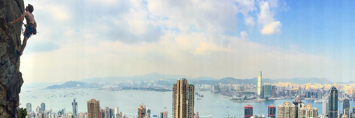
1. Hong Kong 3,354 routes in Region
- Summary:
-
Bouldern, Sportklettern und andere Stile
Lat / Long: 22.335896, 114.187048
Übersicht
Mostly granite on the inner hills and vast quartzite formations by the coastlines.
Beschreibung
With its 1000 sport routes spread over more than 30 crags, Hong Kong can be considered among the best rock climbing destinations in Asia.
Zustieg
Easy access to most crags with public transportation arriving as close as 10 minutes walk in some cases.
Geschichte
The history of rock climbing in Hong Kong starts in the 50s following the British wave of explorers.
Interesting reading, a guide to Hong Kong Rock Climbing from 1968 : http://hongkongclimbing.files.wordpress.com/2012/06/a_guide_to_rockclimbinginhongkong.pdf
1.1. Hong Kong Island 1,224 routes in Area
- Summary:
-
Sportklettern, Bouldern und andere Stile
Lat / Long: 22.247975, 114.188233
Beschreibung
Hong Kong Island - most crags are easily accessible by public transport + a short taxi ride.
1.1.1. Central Crags 149 routes in Area
- Summary:
-
Hauptsächlich Sportklettern
Lat / Long: 22.278738, 114.147899
Übersicht
Grades are easy to moderate and the route quality is high.
Beschreibung
Central crags is located right above the heart of Hong Kong, Central District.
Einschränkungen
Zustieg
The crag can be approached from either the end of Po Shan Road or Old Peak Road.
From Po Shan Road (Green minibus n°3 from IFC) : Climb up the concrete maintenance staircase to the top of the slope at the end of the road. From the top of the staircase follow an older set of stairs a meter or two higher up until you reach an old, slightly overgrown footpath. Turn left and follow this for 10 minutes until you reach a drainage line.
From Old Peak Road: Take a taxi to 23 Old Peak Road or Green minibus n°2 (from IFC). Follow the flat walking path past the small pagoda, contouring around the hill through jungle. After 5 minutes or so, just after crossing some granite slabs, the path climbs steeply up a narrow flight of stairs before continuing around the hillside to reach the same drainage channel described above. Follow the drainage channel upstream for 5 minutes until you reach the base of a small cliff.
Traverse right along the base of this (fixed rope in place) until you reach the bottom of a fixed line. The fixed line leads approximately 30m up a steep slab to the base of the crag, where a limited amount of space is available.
1.1.2. Central Nu 20 routes in Area
- Summary:
-
Alle Sportklettern
1.1.3. Bowen Road 7 routes in Area
- Summary:
-
Hauptsächlich traditionelles Klettern
Lat / Long: 22.270870, 114.176569
1.1.4. Mount Nicholson 34 routes in Crag
- Summary:
-
Hauptsächlich Sportklettern
Lat / Long: 22.260388, 114.185600
Beschreibung
Zustieg
Bus 6, 41A, 63, 66, 76 or Green Minibus 5 to Hong Kong Tennis Centre (香港網球中心).
1.1.5. Stubbs Road Slabs 1 route in Area
- Summary:
-
Alle traditionelles Klettern
Lat / Long: 22.261538, 114.188233
1.1.6. Blacks Link 12 routes in Area
- Summary:
-
traditionelles Klettern und Sportklettern
Lat / Long: 22.258131, 114.186466
Zustieg
The easiest approach to the crag is to head up Stubbs Road to Wong Nai Chung Gap/黃泥涌峽 (well served by either taxi or bus 6, 76 or Green Minibus 5). From there go along Blacks Link to the end of the road.
1.1.7. Black Crag 32 routes in Crag
- Summary:
-
Hauptsächlich Sportklettern
Lat / Long: 22.257973, 114.185705
Beschreibung
Nice slab granite climbing.
Einschränkungen
Zustieg
The easiest approach to the crag is to head up to Wong Nai Chung Gap/黃泥涌峽 (well served by either taxi or bus 6 from Central, 76 or Green Minibus 5 from Causeway Bay). From there go along Blacks Link to the end of the road. Follow the concrete trail around the hillside, beneath some engineered slopes. At the far end of the slopes a drainage channel cuts back up the hill. Jump over the fence at the marker BL63. Follow this to the top of the slope and then continue up the eroded ground above. A dirt trail leads from this to the base of the crag.
1.1.8. Sunset Wall 8 routes in Cliff
- Summary:
-
Alle Sportklettern
Lat / Long: 22.272019, 114.200127
1.1.9. Tai Hang Slabs 10 routes in Cliff
- Summary:
-
Alle Sportklettern
Lat / Long: 22.277587, 114.196901
Beschreibung
Topo : Francis Haden, Hong Kong Rock, 2020
Zustieg
Start at Serenade bus stop (11, 41A, 63) : slope steps.
2 abseils stations.
1.1.10. Monkey Buttress 43 routes in Crag
- Summary:
-
Hauptsächlich Sportklettern
Lat / Long: 22.282899, 114.197186
Übersicht
Not very tall (12/13 mt), granite with many vertical cracks all along. Hand jamming and side pulling required on many of the routes.
Beschreibung
A nice granite wall with super easy access.
Einschränkungen
Zustieg
Take bus 25, 25A, 27, 41A, 85 or Green Minibus 25, 49M to Braemar Hill (寶馬山). From the end of Braemer Hill Road take the small path on the right. Following the steps, cross the river keep following it upstream and take the left up the obvious path after 20 mt. Keeping your right and following the fixed ropes you will get to the crag in not more than 5 minutes walk.
1.1.11. Morning Buttress 19 routes in Cliff
- Summary:
-
Sportklettern und traditionelles Klettern
Lat / Long: 22.282048, 114.206088
1.1.12. Garden Buttress 8 routes in Cliff
- Summary:
-
Alle Sportklettern
Lat / Long: 22.279038, 114.206712
1.1.13. Tai Koo Boulders 33 routes in Area
- Summary:
-
Alle Bouldern
Lat / Long: 22.274291, 114.213725
Beschreibung
1.1.14. General Rock 16 routes in Area
- Summary:
-
Alle Sportklettern
Lat / Long: 22.272854, 114.222045
1.1.15. Mount Parker Crags 23 routes in Crag
- Summary:
-
Alle Sportklettern
Lat / Long: 22.267904, 114.223537
Beschreibung
1.1.16. Silver Bay 30 routes in Area
- Summary:
-
Bouldern und Sportklettern
Lat / Long: 22.260083, 114.255123
1.1.17. Cape Collinson 64 routes in Crag
- Summary:
-
Alle Sportklettern
Lat / Long: 22.254436, 114.255526
Beschreibung
Zustieg
MTR Chai Wan Station, then taxi to Cape Collinson Correctional Institution (歌連臣角懲教所) or 18M Green Minibus at 12:30. From the prison, 18M Green Minibus at 15:15 or 17:00 to Chai Wan Station.
1.1.18. Shek O 349 routes in Area
- Summary:
-
Hauptsächlich Bouldern
Lat / Long: 22.230414, 114.254469
Beschreibung
https://hongkongclimbing.com/guide/shek-o/
https://hongkongclimbing.com/guide/hong-kong/shek-o-bouldering/
1.1.19. To Tei Wan 19 routes in Cliff
- Summary:
-
Sportklettern und Bouldern
Lat / Long: 22.227996, 114.236207
Beschreibung
Topo : Francis Haden, Hong Kong Rock, 2020
Zustieg
Line 9, Bus stop To Tei Wan/土地灣 (Dragon's back entrance).
1.1.20. Hok Tsui 0 routes in Boulder
1.1.21. Stanley Peninsula 78 routes in Area
- Summary:
-
Bouldern, traditionelles Klettern und Sportklettern
Lat / Long: 22.205449, 114.217634
1.1.22. Chung Hom Kok 146 routes in Crag
- Summary:
-
Hauptsächlich Bouldern
Lat / Long: 22.213708, 114.201266
1.1.23. Ap Lei Chau 111 routes in Area
- Summary:
-
Hauptsächlich Sportklettern
Lat / Long: 22.231742, 114.160339
Beschreibung
Zustieg
Walking Approach 1 (MTR South Horizons Station Exit C, Lee Nam Road) – Walk behind the breakwater to where it meets the cliff face and climb over onto the pebble beach. From here, follow a route that contours along the coastline. It’s the start of an exposed traverse to the crag.
Walking Approach 2 (MTR Lei Tung Station Exit B, Ap Lei Chau Summit) – locate a path that leads around behind the Ap Lei Chau Service Reservoir Playground. From behind the playground, the path steepens very quickly up to the summit itself. The summit is fairly flat so quickly leads to an equally steep descent on the other side down to the beach.
1.1.24. Pok Fu Lam 12 routes in Cliff
- Summary:
-
Alle Sportklettern
Lat / Long: 22.265611, 114.138826
Beschreibung
Topo : Francis Haden, Hong Kong Rock, 2020
Routes are described right to left.
1.1.25. Verm City 0 routes in Gym
1.1.26. Just Climb 0 routes in Gym
1.1.27. Attic V 0 routes in Gym
1.2. Kowloon 499 routes in Area
- Summary:
-
Sportklettern, traditionelles Klettern und andere Stile
Lat / Long: 22.325398, 114.190203
1.2.1. Beacon Hill 79 routes in Crag
- Summary:
-
Hauptsächlich Sportklettern
Lat / Long: 22.346753, 114.169088
Beschreibung
Short, easily accessible sport routes on top quality, rough as it comes, granite make this crag almost as popular as Technical Wall, Tung Lung Chau.
Einschränkungen
Beware of monkeys, wild boars and wild dogs during the approach.
Zustieg
Take the MTR to Shek Kip Mei Station, Exit A.
From there you can take:
Minibus 32M till the last station at the end of Lung Ping road. Keep going towards Lung Kai Road(龍駒道). There is a hiking path up the stairs with green handles. Go up the stairs till reaching the reservoir (approach time 20 minutes). (The path would be shown if you search "beacon hill high level fresh water service reservoir" on google map).
Taxi to Lung Yan Road (龍欣道). Just tell the taxi driver to bring you till the end of the road till reaching the reservoir.
To the right of the reservoir a small track leads up the hill to the crag. Approach time approx. 10 minutes.
1.2.2. Lion Rock 55 routes in Cliff
- Summary:
-
Sportklettern und traditionelles Klettern
Lat / Long: 22.351034, 114.185148
Beschreibung
Probably the best view point in Hong Kong featuring the best multi pitch routes.
https://hongkongclimbing.files.wordpress.com/2013/03/lionrock1.pdf
Zustieg
45 min walk uphill from Lion Rock park
1.2.3. Kowloon Peak 208 routes in Area
- Summary:
-
Sportklettern, traditionelles Klettern und andere Stile
Lat / Long: 22.340134, 114.222466
Beschreibung
Mostly trad routes on granite rock. Enjoyable view over kowloon bay.
Zustieg
There are two approach paths depending on which crag you want to reach.
For Split Boulder, Aquila Crag, Majestic Slabs and September Crag, the approach path starts by some concrete stairs few hundred meters after the Good Hope primary school.
For all the others crags, you have to take the hiking path that brings to the peak. First get to Fei Ha Rd (a small private road turning left from the start of Fei Ngo Shan Road). From here, walking in, on your right there are two paths that goes parallel uphill and join right below the Skyline crag: the first has a fixed rope and follow an old drain canal; the second is just 20 meter further (recommended).
1.2.4. Devil’s Peak 99 routes in Crag
- Summary:
-
Hauptsächlich Sportklettern
Lat / Long: 22.294027, 114.243204
Beschreibung
Zustieg
From Yau Tong MTR station exit A2 walk straight ahead to the first intersection and turn left. Proceed past the roundabout to a road on the right that leads up the mountainside towards the Chinese Cemetery. Walk up for about 10 minutes until coming to a flight of stairs on the left side of the road. Follow the Wilson Trail to the top of the obvious slabs. It is necessary to abseil down (bolt anchor) the route of Special Forces to the bottom of the main slab (60 meters single rope minimum).
1.2.5. Tate’s Cairn 13 routes in Crag
- Summary:
-
traditionelles Klettern und Sportklettern
Lat / Long: 22.357883, 114.218048
1.2.6. The Lion Cub 24 routes in Boulder
- Summary:
-
Alle Bouldern
Lat / Long: 22.349636, 114.184212
1.2.7. Arrow Rock 5 routes in Cliff
- Summary:
-
Alle Sportklettern
Lat / Long: 22.348866, 114.187032
1.2.8. Kwun Tong Reservoir 14 routes in Area
- Summary:
-
Alle Sportklettern
Lat / Long: 22.324125, 114.223886
1.2.9. Just Climb 0 routes in Gym
1.2.10. Player 1 route in Gym
- Summary:
-
Alle Bouldern
Lat / Long: 22.341726, 114.136212
1.2.11. Crux 1 route in Gym
- Summary:
-
Alle Bouldern
Lat / Long: 22.322783, 114.167733
1.3. Lantau Island 176 routes in Area
- Summary:
-
Hauptsächlich Sportklettern
Lat / Long: 22.261234, 113.947809
1.3.1. Temple Crag 121 routes in Area
- Summary:
-
Hauptsächlich Sportklettern
Lat / Long: 22.229369, 113.984010
Beschreibung
New topo on Francis Haden, Hong Kong Rock, 2020
Zustieg
Access by the bottom of the cliff (a small path just after C1403 sign). Access from the summit or exiting onto the summit poses a real risk of rock fall onto climbers below.
1.3.2. Eagle Crag 24 routes in Area
- Summary:
-
Sportklettern und traditionelles Klettern
Lat / Long: 22.228559, 113.977823
Beschreibung
Zustieg
Abseiling in case of high tides.
1.3.3. Black Kite Crag 9 routes in Area
- Summary:
-
Sportklettern und Top Roping
Lat / Long: 22.290665, 114.020305
Zustieg
Head to Lantau’s Discovery Bay via ferries from Central or bus from Tung Chung. Once at DB ferry pier walk towards the Marina Club. At the junction where the road on your left goes up hill , stay on the right and head towards the pier. Behind the guards box, follow the footpath signposted towards Mui Wo or Nim Shue Wan. Walk past the first and second beaches to a village. Follow the concrete path uphill and then back down through an area of banana trees. Upon reaching the first white cement hut, on your right with the beach on your left, follow steps down to the beach through a vegetable plot. Turn left at the beach and walk to its end from where the crag is easily recognised.
1.3.4. River Crag 10 routes in Crag
- Summary:
-
Alle Sportklettern
Lat / Long: 22.267834, 113.960751
1.3.5. Yellow dragon stream 2 routes in Cliff
- Summary:
-
Alle Deep Water Soloing
Lat / Long: 22.267594, 113.959438
1.3.6. Cheung Sha Beach Boulders 10 routes in Field
- Summary:
-
Alle Bouldern
Lat / Long: 22.233916, 113.952982
1.4. New Territories 1,076 routes in Area
- Summary:
-
Hauptsächlich Bouldern
Lat / Long: 22.399171, 114.188621
1.4.1. Tsuen Wan Boulders 322 routes in Area
- Summary:
-
Alle Bouldern
Lat / Long: 22.380345, 114.092693
1.4.2. Waterfall rock 10 routes in Crag
- Summary:
-
Alle traditionelles Klettern
Lat / Long: 22.356012, 114.374081
Übersicht
The crag is formed by basalt columns similar to those seen at classic locations such as Giants Causeway in Ireland, only here the rock has been subjected to a little more in the way of tropical weathering. As such, the rock is mostly solid but has a thin covering of flakey weathered rock that will fall off with use. The top of the crag is very loose and the safest exit is by moving right along the ridge towards the headland. Beware of occasional very large unattached rocks. Helmets are recommended.
Beschreibung
Gear is plentiful throughout nearly all routes, small wires and small to medium cams, and as such it is requested that climbers retain a traditional ethic when climbing here.
A full ropes length is needed for the left hand side of the crag. All the routes completed so far have been up obvious crack systems, however plenty of potential remains for harder face and arête routes remains.
The bottom of the crag is located at a wave cut platform which can get covered by the sea if a big swell is running so its best to visit the crag during low tide / periods of generally calm weather.
https://hongkongclimbing.files.wordpress.com/2013/03/waterfallcrag.pdf
Einschränkungen
This approach can be made in all but high tides. However the bottom of the cliffs are washed by waves if there is a swell running so flat seas are advisable.
Zustieg
The approach will take you about an hour from the gates of the national park in a taxi.
From Sai Kung town take a bus to the country park entrance on Tai Mong Tsai Road. From here it is necessary to take a taxi to the end of the East Dam of High Island Reservoir (by the large hexagonal sea defenses.) Walk to the far end of the sea wall, passing the outcrop of Po Pin Chau, and cross over the fence before continuing along the headland on a small path.
Cross a small stream and ascend to the saddle of the hill (Fa Shan). The path splits into three when you reach the headland. Follow the steep path which cuts directly down the pebble beach (撿豬灣滾石灘 Kim Chu Wan) and carry along the coast, around two head lands (past some otherpotentially worthwhile crags) until Waterfall Rock - Fashion Crag is reached.
Ethik
Trad.
Geschichte
Developed by Matt Tranter and Ben George in 2004. Does not get much traffic because of the difficulty in getting here, the lack of bolts and the fact that most people in Hong Kong would rather be poked with sharp sticks than be seen in the New Territories!
1.4.3. Salong 16 routes in Crag
- Summary:
-
Alle Sportklettern
Lat / Long: 22.382093, 114.005725
1.4.4. The White Cliff 14 routes in Cliff
- Summary:
-
Alle Sportklettern
Lat / Long: 22.391212, 113.955412
1.4.5. Clearwater Bay 26 routes in Crag
- Summary:
-
Hauptsächlich traditionelles Klettern
Lat / Long: 22.265188, 114.301461
Einschränkungen
The Golf Club no longer permits access to Promontory Point or Clubhouse Cliffs.
1.4.6. Tai Hang Tun 13 routes in Crag
- Summary:
-
Sportklettern, traditionelles Klettern und Top Roping
Lat / Long: 22.291561, 114.305749
1.4.7. Ma Tai Stream 297 routes in Crag
- Summary:
-
Hauptsächlich Bouldern
Lat / Long: 22.407266, 114.232237
1.4.8. Spider Rock 8 routes in Cliff
- Summary:
-
Alle traditionelles Klettern
Lat / Long: 22.402915, 114.307372
1.4.9. Kai Kung Leng 113 routes in Area
- Summary:
-
Alle Bouldern
Lat / Long: 22.463671, 114.074364
1.4.10. Tai Mo Shan Boulders 170 routes in Field
- Summary:
-
Alle Bouldern
Lat / Long: 22.404192, 114.121449
1.4.11. Buffalo Boulders 23 routes in Field
- Summary:
-
Alle Bouldern
Lat / Long: 22.392758, 114.244480
Beschreibung
1.4.12. SCL Boulder 14 routes in Boulder
- Summary:
-
Alle Bouldern
Lat / Long: 22.383354, 114.241697
Beschreibung
Zustieg
The boulder is best approached via Mui Tsz Lam, which is accessed by heading south from Exit B of Tai Shui Hang MTR Station to get to Mui Tsz Lam Rd, which is followed to the village of the same name. From Mui Tsz Lam, follow the very pleasant Mau Ping Ancient Trail to get to Mau Ping San Uk. Pass through the village to reach a small bridge over the stream. The boulder itself is located just up the stream, to the south of the bridge.
1.4.13. The Watch Tower 8 routes in Cliff
- Summary:
-
Sportklettern und Bouldern
Lat / Long: 22.456684, 114.336861
1.4.14. Razor Ridge 5 routes in Cliff
- Summary:
-
Alle Sportklettern
Lat / Long: 22.298131, 114.311042
1.4.15. Hong Kong Climbing Park 0 routes in Gym
1.4.16. Pak Shui Wun 37 routes in Area
- Summary:
-
Alle Bouldern
Lat / Long: 22.339620, 114.266417
Beschreibung
The lone big bloc (and several small blocs) on the southern side of Pak Shui Wun beach near the Hong Kong University of Science and Technology (HKUST) is home to a fine collection of mid-grade gems. Originally ‘discovered’ some years ago by Chris Tang, the bloc has recently been brought kicking and screaming into the 2020’s by Gordon Hoi and Matthew Sze who have repeated most of Chris’ lines and added a few of their own too (big thanks to Gordon for the guide info herein).
Zustieg
Take bus/mini-bus to HKUST NorthGate, there is a path leading to concrete stairs nearthebus station. Follow the stairs all the way to PakShui Wun beach, walk to the south and you will see the giant Bonanza.
1.5. Tung Lung Chau 196 routes in Area
- Summary:
-
Sportklettern, traditionelles Klettern und Bouldern
Lat / Long: 22.247529, 114.291673
- Weekends and Public Holidays
- a ferry runs to Tung Lung Chau from Sai Wan Ho typhoon shelter (exit A1 from Sai Wan Ho MTR Station and walk rightwards to the coastline) at 09:00, 09:45, 10:30, 11:15, 12:00, 12:45, 15:15, 16:40.
- Weekday access
- Sampans (for up to 4 people) can usually be rented from the typhoon shelter at Sai Wan Ho by just showing up and haggling with the boat operator. A speed boat (with capacity for 10 people) can be arranged by calling Mr Cheng at: 9080 3754.
Beschreibung
Hong Kongs premiere climbing area, Tung Lung Chau, contains probably the highest concentration of quality sport climbs in the territory.
https://hongkongclimbing.files.wordpress.com/2013/03/tunglung.pdf
Einschränkungen
Public transportation is only available during weekend and public holidays.
During weekdays a private transportation can be arranged. Check the "approach" section for details.
Zustieg
A ferry also runs from the pier at Sam Ka Tsuen, Lei Yue Mun (approach by taxi from Lam Tin MTR Station) at 08:20, 09:25, 10:40, 11:50, 13:20, 14:35, 15:45, 16:55.
Upon arrival at the island follow the obvious concrete path, signposted towards Tung Lung Fort. The large boulder located atop a small hillock is Kite Rock and contains half a dozen short bolted routes. Continue along the path, past the Holiday Store (which provides free topo’s, strong coffee and excellent dumplings), to a camping ground. From here you may make your way to the different climbing areas/crags.
Übernachtung
Camping is possible all year long.
1.5.1. Technical Wall 43 routes in Crag
- Summary:
-
Alle Sportklettern
Lat / Long: 22.254468, 114.297173
Beschreibung
Single pitch sport climbs on solid volcanic rock in a highly sociable setting make Technical Wall by far Hong Kongs most popular crag. Its worth noting that Technical Wall can get very busy on Sundays and Public Holidays and crowds in excess of 50 people at the wall have been seen.
Sunny aspect in the morning and pleasant sea breeze on hot days.
Zustieg
20 minute easy approach walk from ferry pier.
1.5.2. Sea Gully 61 routes in Cliff
- Summary:
-
Hauptsächlich Sportklettern
Lat / Long: 22.253662, 114.295702
1.5.3. The Far Side 15 routes in Unknown
- Summary:
-
Alle Sportklettern
Lat / Long: 22.254151, 114.296121
1.5.4. Beach Bunker 1 route in Area
- Summary:
-
Alle Sportklettern
Lat / Long: 22.258310, 114.294666
Beschreibung
Single route on the Beach.
Zustieg
Walk from the pier.
1.5.5. Kite Rock 6 routes in Crag
- Summary:
-
Alle Sportklettern
Lat / Long: 22.254944, 114.291892
Beschreibung
Short sport climbs on a small boulder of very rough pocketed volcanic rock perched high on the hillside.
7 bolted micro-routes on a large boulder of very rough volcanic tuff. 10 minute easy approach walk from ferry pier. Sunny aspect throughout the majority of the day.
Rebolted in 2020.
1.5.6. Big Wall 15 routes in Cliff
- Summary:
-
Alle Sportklettern
Lat / Long: 22.252943, 114.295846
Beschreibung
Tung Lung’s Big Wall is a multi pitch sport climbs in a stunning situation, especially when a big swell is running.
WARNING: This wall contains many loose blocks, although most routes (particularly those in the higher grades) are on relatively solid rock. It should therefore only be approached by a competent party. If there are any signs of other parties already on the wall extreme caution should be taken when abseiling in. Please do not attempt to clean the blocks off this wall, there’s too many, it’s too dangerous, and it could seriously alter the character of many of the routes as falling blocks smash into them.
Please also note that, other than jumaring up a fixed line or swimming around into Sea Gully (neither of which are particularly desirable), the routes described are the only means of escape once you’ve abseiled in. If you have any doubts of your ability to safely climb the routes please do not attempt to climb on the wall.
Zustieg
Abseiling
1.5.7. Tathung Point 48 routes in Crag
- Summary:
-
Hauptsächlich traditionelles Klettern
Lat / Long: 22.239309, 114.288606
Ethik
Trad place, do not bolt.
1.5.8. The Pirates Bay 7 routes in Field
- Summary:
-
Alle Bouldern
Lat / Long: 22.257823, 114.295403
1.6. Lamma Island 87 routes in Area
- Summary:
-
Bouldern, Sportklettern und traditionelles Klettern
Lat / Long: 22.203620, 114.130384
1.6.1. Sok Kwu Wan 24 routes in Area
- Summary:
-
Hauptsächlich Sportklettern
Lat / Long: 22.207335, 114.135706
Zustieg
Ferry timetable : http://www.hkkf.com.hk/index.php?op=timetable&page=sokkwuwan&style=en
1.6.2. Mount Stenhouse 5 routes in Cliff
- Summary:
-
Alle traditionelles Klettern
Lat / Long: 22.192809, 114.125522
1.6.3. Lamma Boulders 40 routes in Area
- Summary:
-
Alle Bouldern
Lat / Long: 22.200548, 114.137813
Beschreibung
Einschränkungen
From Central Ferry Pier No. 4 take the ferry to Sok Kwu Wan, which departs from the left side of the ferry pier (check schedules). The ferries from right side go to Yung Shue Wan and add about 45 minutes to the approach walk so avoid these!
From the ferry pier in Sok Kwu Wan head right and follow the main path past all the sea food restaurants to a small open area. At the far left corner of this square is a staircase and footpath which lead up the hill (signposted to Tung O). Follow this path uphill until a small shelter is reached, approximately 20 minutes. Taking the right hand branch in the footpath leads to the Pagoda Boulders, whilst the left takes you to the Ling Kok Shan Boulders.
1.6.4. Hung Shing Yeh Boulders 5 routes in Field
- Summary:
-
Alle Bouldern
Lat / Long: 22.217668, 114.119377
1.6.5. Sham Wan Beach 13 routes in Field
- Summary:
-
Bouldern, traditionelles Klettern und Sportklettern
Lat / Long: 22.190148, 114.136181
Beschreibung
Einschränkungen
Closed to the public between 1st April and 31st October.
1.7. Cheung Chau 96 routes in Area
- Summary:
-
Alle Bouldern
Lat / Long: 22.207789, 114.029154
1.7.1. Don Bosco Boulders 54 routes in Field
- Summary:
-
Lat / Long: 22.204281, 114.039626
1.7.2. Southside 25 routes in Field
- Summary:
-
Lat / Long: 22.196374, 114.022574
1.7.3. Reclining Rock 0 routes in Field
1.7.4. Coral Coast 17 routes in Field
- Summary:
-
Lat / Long: 22.220127, 114.034561